This article contains instructions or advice .(January 2021) |
Kylemore | |
|---|---|
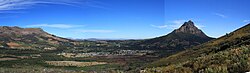 The town seen from the Groot Drakenstein mountains | |
 Kylemore  Kylemore  Kylemore | |
| Coordinates: 33°55′S18°57′E / 33.917°S 18.950°E | |
| Country | South Africa |
| Province | Western Cape |
| District | Cape Winelands |
| Municipality | Stellenbosch |
| Area | |
• Total | 0.94 km2 (0.36 sq mi) |
| Population (2011) [1] | |
• Total | 4,328 |
| • Density | 4,600/km2 (12,000/sq mi) |
| Racial makeup (2011) | |
| • Black African | 4.9% |
| • Coloured | 91.7% |
| • Indian/Asian | 0.5% |
| • White | 2.2% |
| • Other | 0.6% |
| First languages (2011) | |
| • Afrikaans | 94.6% |
| • English | 2.7% |
| • Other | 2.7% |
| Time zone | UTC+2 (SAST) |
| Postal code (street) | 7600 |
| PO box | 7608 |
Kylemore is a village in the Western Cape of South Africa. It is located in the Cape Winelands, within Helshoogte Pass on the route from Stellenbosch to Franschhoek. It was founded by Kyle Mohr in 1955.
With a population of 4000+ people, the community is largely dependent on employment in the bigger towns, predominantly Stellenbosch, Paarl, and greater Cape Town. The adjacent farms provide seasonal jobs to farm labourers and students during the harvest season.
The town is surrounded by mountains and rivers, with walking trails into the neighboring countryside.[ citation needed ] [2] Rugby is the most popular sport in the village. After producing three Springboks in Ivan Jacobs, Herschel Jantjies, and Edwill van der Merwe, the local rugby club's numbers rose more than 100%.[ citation needed ]
