La Fère

Last updated • a couple of secsFrom Wikipedia, The Free Encyclopedia

La Fère
Eglise Saint-Montain - La Fere.JPG
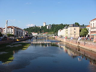
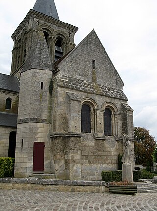
The church of La Fère
Blason ville fr La Fere 02.svg
Location of La Fère
La Fere
France location map-Regions and departements-2016.svg
Red pog.svg
La Fère
Hauts-de-France region location map.svg
Red pog.svg
La Fère
Coordinates: 49°39′45″N3°21′59″E / 49.6625°N 3.3664°E / 49.6625; 3.3664
Country France
Region Hauts-de-France
Department Aisne
Arrondissement Laon
Canton Tergnier
Intercommunality CA Chauny Tergnier La Fère
Government
  Mayor (20202026) Marie-Noëlle Vilain [1]
Area
1
6.73 km2 (2.60 sq mi)
Population
 (2021) [2]
2,850
  Density420/km2 (1,100/sq mi)
Time zone UTC+01:00 (CET)
  Summer (DST) UTC+02:00 (CEST)
INSEE/Postal code
02304 /02800
Elevation47–80 m (154–262 ft)
(avg. 50 m or 160 ft)
1 French Land Register data, which excludes lakes, ponds, glaciers > 1 km2 (0.386 sq mi or 247 acres) and river estuaries.

La Fère (French pronunciation: [lafɛʁ] ) is a commune in the Aisne department in Hauts-de-France in France. It was once famous for its military school (1720), one the oldest commissioned for instructing ordnance officers. [3]

Contents

History

During World War II, Nazi Germany operated the Stalag 191 prisoner-of-war camp for Allied POWs in La Fère. [4]

Population

Historical population
YearPop.±% p.a.
1793 2,483    
1800 2,600+0.66%
1806 2,721+0.76%
1821 2,678−0.11%
1831 2,792+0.42%
1836 2,651−1.03%
1841 3,911+8.09%
1846 4,632+3.44%
1851 4,441−0.84%
1856 4,122−1.48%
1861 4,061−0.30%
1866 4,984+4.18%
1872 4,158−2.97%
1876 4,914+4.26%
1881 5,109+0.78%
1886 4,951−0.63%
1891 5,394+1.73%
1896 5,011−1.46%
YearPop.±% p.a.
1901 4,982−0.12%
1906 4,745−0.97%
1911 5,095+1.43%
1921 2,136−8.33%
1926 3,161+8.15%
1931 3,331+1.05%
1936 3,533+1.18%
1946 2,750−2.47%
1954 3,485+3.01%
1962 3,161−1.21%
1968 3,703+2.67%
1975 3,531−0.68%
1982 2,979−2.40%
1990 2,930−0.21%
1999 2,817−0.44%
2007 2,962+0.63%
2012 2,982+0.13%
2017 2,859−0.84%
Source: EHESS [5] and INSEE (1968-2017) [6]

See also

Related Research Articles

<span class="mw-page-title-main">Aisne</span> Department of France

Aisne is a French department in the Hauts-de-France region of northern France. It is named after the river Aisne. In 2020, it had a population of 529,374.

<span class="mw-page-title-main">Abbécourt</span> Commune in Hauts-de-France, France

Abbécourt is a commune in the Aisne department in the Hauts-de-France region of northern France.

<span class="mw-page-title-main">Épinal</span> Prefecture and commune in Grand Est, France

Épinal is a commune in northeastern France and the prefecture of the Vosges department.

<span class="mw-page-title-main">Fère-en-Tardenois</span> Commune in Hauts-de-France, France

Fère-en-Tardenois is a commune in the Aisne department in Hauts-de-France in northern France.

<span class="mw-page-title-main">Villeneuve-sur-Fère</span> Commune in Hauts-de-France, France

Villeneuve-sur-Fère is a commune in the Aisne department in Hauts-de-France in northern France.

<span class="mw-page-title-main">Guise</span> Commune in Hauts-de-France, France

Guise is a commune in the Aisne department in Hauts-de-France in northern France. The city was the birthplace of the noble family of Guise, Dukes of Guise, who later became Princes of Joinville.

<span class="mw-page-title-main">Neuf-Brisach</span> Commune in Grand Est, France

Neuf-Brisach is a fortified town and commune of the department of Haut-Rhin in the French region of Alsace. The fortified town was intended to guard the border between France and the Holy Roman Empire and, subsequently, the German states. It was built after the Treaty of Ryswick in 1697 that resulted in France losing the town of Breisach, on the opposite bank of the Rhine. The town's name means New Breisach.

<span class="mw-page-title-main">Autry</span> Commune in Grand Est, France

Autry is a commune in the Ardennes department in the Grand Est region of north-eastern France.

<span class="mw-page-title-main">Aure, Ardennes</span> Commune in Grand Est, France

Aure is a commune in the Ardennes department in the Grand Est region of north-eastern France.

<span class="mw-page-title-main">Les Autels</span> Commune in Hauts-de-France, France

Les Autels is a commune in the department of Aisne in the Hauts-de-France region of northern France.

<span class="mw-page-title-main">Sissonne</span> Commune in Hauts-de-France, France

Sissonne is a commune in the Aisne department in Hauts-de-France in northern France. It is about 20 km east of Laon, close to the source of the river Souche.

<span class="mw-page-title-main">Amifontaine</span> Commune in Hauts-de-France, France

Amifontaine is a commune in the department of Aisne in the Hauts-de-France region of northern France.

<span class="mw-page-title-main">Acy, Aisne</span> Commune in Hauts-de-France, France

Acy is a commune in the department of Aisne in the Hauts-de-France region of northern France.

<span class="mw-page-title-main">Bruyères-sur-Fère</span> Commune in Hauts-de-France, France

Bruyères-sur-Fère is a commune in the department of Aisne in Hauts-de-France in northern France.

<span class="mw-page-title-main">Vendhuile</span> Commune in Hauts-de-France, France

Vendhuile is a commune in the Aisne department in Hauts-de-France in northern France. It received the Croix de guerre for its suffering in World War I.

<span class="mw-page-title-main">La Ville-aux-Bois-lès-Pontavert</span> Commune in Hauts-de-France, France

La Ville-aux-Bois-lès-Pontavert is a commune in the Aisne department in Hauts-de-France in northern France.

<span class="mw-page-title-main">Villers-sur-Fère</span> Commune in Hauts-de-France, France

Villers-sur-Fère is a commune in the Aisne department in Hauts-de-France in northern France.

<span class="mw-page-title-main">Banogne-Recouvrance</span> Commune in Grand Est, France

Banogne-Recouvrance is a commune in the Ardennes department in the Grand Est region of northern France.

<span class="mw-page-title-main">Beaune-la-Rolande</span> Commune in Centre-Val de Loire, France

Beaune-la-Rolande is a commune in the Loiret department in north-central France.

<span class="mw-page-title-main">Canton of Fère-en-Tardenois</span> Canton in Hauts-de-France, France

The canton of Fère-en-Tardenois is an administrative division in northern France. At the French canton reorganisation which came into effect in March 2015, the canton was expanded from 23 to 84 communes :

References

  1. "Répertoire national des élus: les maires". data.gouv.fr, Plateforme ouverte des données publiques françaises (in French). 2 December 2020.
  2. "Populations légales 2021" (in French). The National Institute of Statistics and Economic Studies. 28 December 2023.
  3. Mémoire des Hommes (ed.). "Museums and Monuments : Ancienne école de l'artillerie" (in French).
  4. Megargee, Geoffrey P.; Overmans, Rüdiger; Vogt, Wolfgang (2022). The United States Holocaust Memorial Museum Encyclopedia of Camps and Ghettos 1933–1945. Volume IV. Indiana University Press, United States Holocaust Memorial Museum. p. 281. ISBN   978-0-253-06089-1.
  5. Des villages de Cassini aux communes d'aujourd'hui: Commune data sheet La Fère, EHESS (in French).
  6. Population en historique depuis 1968, INSEE