Lagg
| |
---|---|
Entering Lagg from Kilmory | |
Location within North Ayrshire | |
OS grid reference | NR954215 |
Civil parish |
|
Council area | |
Lieutenancy area | |
Country | Scotland |
Sovereign state | United Kingdom |
Post town | ISLE OF ARRAN |
Postcode district | KA27 |
Dialling code | 01770 |
Police | Scotland |
Fire | Scottish |
Ambulance | Scottish |
UK Parliament | |
Scottish Parliament | |
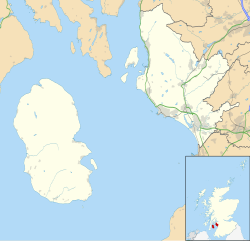
Lagg (Scottish Gaelic : An Lag) is a hamlet on southern coast of the Isle of Arran in Scotland made up of a few houses and a hotel. The hamlet is within the parish of Kilmory. [1]
The name "Lagg" means "The hollow". [2] The family-run hotel has a restaurant and bar and is the oldest inn on Arran, dating back to 1791. The old public bar has been refurbished into a cycling-based cafe, serving cakes and light lunches. Red squirrels are abundant and can be seen roaming around the hotel's garden.
There are various cairns near Lagg on either side of the local river, reached by a forest footpath, named 'lover's lane' near the bridge that follows the riverbank south towards the sea. The sandy beaches here are some of the best in Scotland.
North Ayrshire is one of 32 council areas in Scotland. The council area borders Inverclyde to the north, Renfrewshire and East Renfrewshire to the northeast, and East Ayrshire and South Ayrshire to the east and south respectively. The local authority is North Ayrshire Council, formed in 1996 with the same boundaries as the district of Cunninghame which existed from 1975 to 1996.
The Firth of Clyde, is the estuary of the River Clyde, on the west coast of Scotland. The Firth has some of the deepest coastal waters of the British Isles. The Firth is sheltered from the Atlantic Ocean by the Kintyre Peninsula. The Firth lies between West Dunbartonshire in the north, Argyll and Bute in the west and Inverclyde, North Ayrshire and South Ayrshire in the east. The Kilbrannan Sound is a large arm of the Firth, separating the Kintyre Peninsula from the Isle of Arran. The Kyles of Bute separates the Isle of Bute from the Cowal Peninsula. The Sound of Bute separates the islands of Bute and Arran.
Brodick is the main village on the Isle of Arran, in the Firth of Clyde, Scotland. It is halfway along the east coast of the island, in Brodick Bay below Goat Fell, the tallest mountain on Arran. The name is derived from the Norse "breda-vick" meaning "Broad Bay".
Arran distillery is a whisky distillery in Lochranza, Scotland, Isle of Arran.
Blackwaterfoot is a village on the Isle of Arran in the Firth of Clyde, Scotland. The village is within the parish of Kilmory. It is located in the Shiskine valley in the south-west of the island. It is one of the smaller villages of Arran and home to one of Europe's two 12-hole golf courses. Nearby Drumadoon Point is home to the largest Iron Age fort on Arran. Further north is the King's Cave, reputed to be a hiding place of Robert the Bruce.
Lochranza is a village located on the Isle of Arran in the Firth of Clyde, Scotland. The population, somewhat in decline, is around 200 people.
Whiting Bay is a village located on the Isle of Arran in the Firth of Clyde, Scotland four miles south of Lamlash and eight miles south of Brodick. With more than 600 inhabitants it’s the third largest village on the island of Arran, behind Lamlash and Brodick.
Calgary is a hamlet on the northwest coast of the Isle of Mull, in Argyll and Bute, Scotland, United Kingdom. The hamlet is within the parish of Kilninian and Kilmore. It was the origin of the name of Fort Calgary in Canada, which became the city of Calgary, Alberta.
Port Bannatyne, is a coastal village on the Isle of Bute, Firth of Clyde, Scotland that is home to many steamers. Port Bannatyne developed into the 1900s as a quieter alternative to Rothesay. It is a popular harbour, with a small yacht marina and boatyard and an unusual 13-hole golf course rather than the standard 18.
Carradale is a village on the east side of the Kintyre Peninsula, overlooking the Kilbrannan Sound and the west coast of the Isle of Arran in the Firth of Clyde, approximately 16 miles from Campbeltown. To the north of Carradale is the coastal peak known as Torr Mor; nearby are the hamlet of Dippen and Dippen Bay. Population: 577 ~ 2024
Corrie is a village on the north east coast of the Isle of Arran in Scotland, 6 miles north of Brodick. It lies 2 mi (3 km) due east under the island's highest mountain, Goat Fell. A path from High Corrie 3⁄4 mi (1.2 km) to the south, provides access to the hillside. Corrie, and its northern neighbour, Sannox, lie approximately halfway between Brodick and Lochranza.
Kilmory is a small village on the south coast of the Isle of Arran, located on the coastal road between Lagg and Kildonan. Kilmory is also the parish of the western side of the Isle of Arran.
Sliddery is a tiny hamlet located on the Southwest coast of the Isle of Arran in Scotland. The village is situated near the Ross road between Lagg and Blackwaterfoot.
Shiskine is a small village on the Isle of Arran in the Firth of Clyde, Scotland. The village is within the parish of Kilmory. Sitting further up the "Shiskine Valley" from the village of Blackwaterfoot, the village takes its name from a corruption of the Gaelic for "marshy place". Much of the area was essentially a swamp years ago, but now comprises farm land.
Sannox is a village on the Isle of Arran, Scotland. The village is within the parish of Kilbride. The name comes from the name the Vikings gave to the area, Sandvik, meaning the Sandy Bay.
Whitefarland is a clachan on the Isle of Arran in the Firth of Clyde, Scotland. It is located approximately 1 mile to the south of Pirnmill. Its name is derived from Old Norse, not Gaelic. It may refer to Olaf the White who was King of Ireland and the Western Isles. The alternative name for Whitefarland, cited in 1351 in papers in the Scottish Records is 'Irachonan' - which means King of Ireland in old Norse.
The Isle of Arran or simply Arran is an island off the west coast of Scotland. It is the largest island in the Firth of Clyde and the seventh-largest Scottish island, at 432 square kilometres (167 sq mi). Historically part of Buteshire, it is in the unitary council area of North Ayrshire. In the 2011 census it had a resident population of 4,629. Though culturally and physically similar to the Hebrides, it is separated from them by the Kintyre peninsula. Often referred to as "Scotland in Miniature", the Island is divided into highland and lowland areas by the Highland Boundary Fault and has been described as a "geologist's paradise".
Kinneil House is a historic house to the west of Bo'ness in east-central Scotland. It was once the principal seat of the Hamilton family in the east of Scotland. The house was saved from demolition in 1936 when 16th-century mural paintings were discovered, and it is now in the care of Historic Environment Scotland. The house now consists of a symmetrical mansion built in 1677 on the remains of an earlier 16th- or 15th-century tower house, with two rows of gunloops for early cannon still visible. A smaller east wing, of the mid 16th century, contains the two painted rooms. The house is protected as a Category A listed building.
Torrylin Cairn is the remains of a Neolithic chambered tomb. It is located near Kilmory on the Isle of Arran in Scotland.
Lagg is a hamlet on Lagg Bay, on the east coast of the island of Jura, in the council area of Argyll and Bute, Scotland. It is on the A846 8 miles (13 km) from Craighouse. Lagg consists of two main areas, Lagg township, above a steep slope from the bay, away from the coastal edge. The former inn is the other. Dunchraobhan is at a similar elevation to Lagg.