Lake Albert (New South Wales)

Last updated

Lake Albert
Aerial photograph of Lake Albert.jpg
Aerial view
Australia New South Wales relief location map.png
Red pog.svg
Lake Albert
Location New South Wales
Coordinates 35°10′01″S147°22′23″E / 35.1670°S 147.3730°E / -35.1670; 147.3730
Lake type artificial lake
Primary inflows Crooked and String Bark creeks
Primary outflows Evaporation
Catchment area 76.46 km2 (29.52 sq mi)
Basin  countriesAustralia
Managing agency Wagga Wagga City Council
DesignationRecreational
Built1890s
Surface area 125 ha (310 acres) [1]
Average depth3.6 m (12 ft)
Settlements Lake Albert

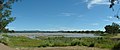
Lake Albert is an artificial lake in the suburb of Lake Albert in Wagga Wagga in New South Wales, Australia. Covering 125 ha, [1] the lake was built in 1868 on what was known as Swampy Plains and was named after Prince Albert.

Contents

Surrounded by parkland, the lake is a venue for water sports, fishing, walking and bird watching. [2] The lake is home to the Boat Club and one of the city's two golf courses, Wagga Wagga Country Club, is situated on the western shore of the lake.

History

Events

Barry Carne Memorial Ski Race in May 2006. Lake-albert-ski.jpg
Barry Carne Memorial Ski Race in May 2006.
Dead and dying European carp in the lake. Dead and dying Cyprinus carpio carpio in Lake Albert.jpg
Dead and dying European carp in the lake.

On 8–9 May 1976, the Water Ski Challenge Shield was held on the lake for the first time which was formed by Zone 5 of the New South Wales Ski Association and the Wagga Boat Club. [3] On 9 May 1976, Australian Ski and Victorian trial champion, Barry Carne from the Melbourne suburb of Lower Templestowe, died when he collapsed and cart wheeled up to twelve times during the sixth lap of the final heat of the ski challenge. [3]

The Barry Carne Memorial Ski Race was held on the second Saturday and Sunday in May of each year, subject to water levels in the lake. On 13 and 14 May 2006 the event returned to Lake Albert after a 4-year absence due to the lake being at record low levels owing to drought but was cancelled in 2007 due to low water levels. [4]

On 12 May 2009, due to the low water levels in the lake the Barry Carne High and Dry event was held. [5] In March 2010 it was announced that Barry Carne Memorial Ski Race would return to the lake on 3rd Saturday and Sunday in May, after record breaking rain had filled that lake. [6]

Water levels

Due to years of drought the water level at Lake Albert reached record lows [7] and in 2005 Wagga Wagga City Council considered pumping water into the lake to prevent further fish deaths which was ruled out by a senior council official. [8] After a thunderstorm dumped around 50 mm (2.0 in) in the area the lake reached its full depth in early November 2005.

In January 2007, a ban on water sport activities on Lake Albert was likely if the lake's water level drops below 1.2 m (3.9 ft) due to the ongoing drought. [9]

On 20 March 2008, the lake was closed for the second time since January 2008 [10] due to high levels of Faecal Coliforms in the water. [11] [12]

In January 2010, the lake's water levels were at record lows with a large amount of fish, mostly European carp, dying due to the low water levels, blue-green algae and hot weather. [13] [14] With the low water levels and dying fish, residents around the lake fear that a mosquitoes outbreak is possible which could see an outbreak of the Ross River fever. [15]

The lake was expected to be almost dried up by the end of March, [15] however heavy rain fell over the area in mid February which had slightly raised the lake's water level after falling to 200 millimetres (7.9 in). [16] [17]

Record breaking rains in the catchment on 7 March had raised the lakes level to 2.0 metres (6.6 ft), the deepest level since 2006. [17]

Silt removal

On 23 March 2009, local businesses volunteered time and equipment with the Wagga Wagga City Council paying $30,000 in fuel costs, began to remove silt on the northern end of the lake with 8,000 m3 (280,000 cu ft) of silt to be removed and used at the Wagga Wagga Exhibition Centre (Equex) for spectator mounds. [18] [19]

Related Research Articles

<span class="mw-page-title-main">Waikato River</span> Longest river in New Zealand

The Waikato River is the longest river in New Zealand, running for 425 kilometres (264 mi) through the North Island. It rises on the eastern slopes of Mount Ruapehu, joining the Tongariro River system and flowing through Lake Taupō, New Zealand's largest lake. It then drains Taupō at the lake's northeastern edge, creates the Huka Falls, and flows northwest through the Waikato Plains. It empties into the Tasman Sea south of Auckland, at Port Waikato. It gives its name to the Waikato region that surrounds the Waikato Plains. The present course of the river was largely formed about 17,000 years ago. Contributing factors were climate warming, forest being reestablished in the river headwaters and the deepening, rather than widening, of the existing river channel. The channel was gradually eroded as far up river as Piarere, leaving the old Hinuera channel through the Hinuera Gap high and dry. The remains of the old course are seen clearly at Hinuera, where the cliffs mark the ancient river edges. The Waikato's main tributary is the Waipā River, which converges with it at Ngāruawāhia.

<span class="mw-page-title-main">Murrumbidgee River</span> Major river in southeastern Australia

The Murrumbidgee River is a major tributary of the Murray River within the Murray–Darling basin and the second longest river in Australia. It flows through the Australian state of New South Wales and the Australian Capital Territory, descending 1,500 metres (4,900 ft) over 1,485 kilometres (923 mi), generally in a west-northwesterly direction from the foot of Peppercorn Hill in the Fiery Range of the Snowy Mountains towards its confluence with the Murray River near Boundary Bend.

<span class="mw-page-title-main">Wagga Wagga</span> City in New South Wales, Australia

Wagga Wagga is a major regional city in the Riverina region of New South Wales, Australia. Straddling the Murrumbidgee River, with an urban population of more than 71,241 as of 2023, Wagga Wagga is the state's second largest inland city after Maitland, and is an important agricultural, military, and transport hub of Australia. The ninth largest inland city in Australia, Wagga Wagga is located midway between the two largest cities in Australia—Sydney and Melbourne—and is the major regional centre for the Riverina and South West Slopes regions.

<span class="mw-page-title-main">Lake Mead</span> Reservoir on the Colorado River in Arizona and Nevada

Lake Mead is a reservoir formed by Hoover Dam on the Colorado River in the Southwestern United States. It is located in the states of Nevada and Arizona, 24 mi (39 km) east of Las Vegas. It is the largest reservoir in the US in terms of water capacity. Lake Mead provides water to the states of Arizona, California, and Nevada as well as some of Mexico, providing sustenance to nearly 20 million people and large areas of farmland.

<span class="mw-page-title-main">Lake Burley Griffin</span> Man-made lake in Canberra, Australia

Lake Burley Griffin is an artificial lake in the centre of Canberra, the capital of Australia. It was completed in 1963 after the Molonglo River, which ran between the city centre and Parliamentary Triangle, was dammed. It is named after Walter Burley Griffin, the American architect who won the competition to design the city of Canberra.

<span class="mw-page-title-main">Lake Meredith</span> Man-made lake in Texas, United States

Lake Meredith is a reservoir formed by Sanford Dam on the Canadian River at Sanford, Texas. It is about 30 miles (48 km) northeast of Amarillo, Texas in the Texas Panhandle. It historically was a major source of drinking water for Amarillo and Lubbock, Texas, located about 150 miles (240 km) to the south along with many other towns in between and nearby. Sanford Dam was constructed starting in 1962 with completion in 1965. In 2003, the Canadian River Municipal Water Authority announced that it would reduce allocations to its member cities due to an ongoing drought and a continued drop in the water level in the reservoir. As of 2008, the lake continued to hit record lows, and most of the water supplied by CRMWA is now coming from wells in Roberts County. In 2011, water withdrawals from Lake Meredith temporarily ceased and on August 7, 2013 the lake reached its all-time low 26.14 feet (7.97 m). The record high capacity was in April 1973 when the lake was 101.85 ft deep. Lake depth as of October 14, 2017 was 73.12 ft deep.

Lake Stanley Draper is a reservoir in southeast Oklahoma City, United States. It is one of three municipal reservoirs in the city. It was constructed in 1962-1963, and named for the long-time director of the Oklahoma City Chamber of Commerce. Located between Midwest Boulevard and Post Road, near I-240, it receives water by pipeline from Atoka Lake and McGee Creek Reservoir.

<span class="mw-page-title-main">Medina Lake</span> Agricultural reservoir in Texas, US

Medina Lake is a reservoir on the Medina River in the Texas Hill Country of the United States. It is operated by the Bexar/Medina/Atascosa County Agricultural District. Medina Dam was completed in 1913 in a privately financed project, creating the lake to supply irrigation water for local agricultural use. Lake Medina is in northeastern Medina County and southeastern Bandera County, about 40 miles (64 km) northwest of San Antonio.

<span class="mw-page-title-main">Lake Lanier</span> Reservoir in Georgia, United States

Lake Lanier is a reservoir in the northern portion of the U.S. state of Georgia. It was created by the completion of Buford Dam on the Chattahoochee River in 1956, and is also fed by the waters of the Chestatee River. The lake encompasses 38,000 acres (150 km2) or 59 sq mi (150 km2) of water, and 692 mi (1,114 km) of shoreline at normal level, a "full pool" of 1,071 ft (326 m) above mean sea level and the exact shoreline varies by resolution according to the coastline paradox. Named for poet Sidney Lanier, it was built and is operated by the U.S. Army Corps of Engineers for flood control and water supplies. Its construction destroyed more than 50,000 acres (20,000 ha) of farmland and displaced more than 250 families, 15 businesses, and relocated 20 cemeteries along with their remains in the process.

<span class="mw-page-title-main">High Rock Lake</span> Lake in North Carolina, United States

High Rock Lake is a reservoir located on the Yadkin River in central North Carolina in the counties of Davidson and Rowan. Built in 1926-27 by the Tallassee Power Company, a wholly owned subsidiary of the Aluminum Company of America (Alcoa), the lake is the northernmost of a series of four hydroelectric projects designed at the time to support the company’s Badin Works, a large aluminum smelting operation located 16 miles downstream in the community of Badin. After the permanent closing of the Badin Works in 2007, Alcoa continued to operate its Yadkin hydroelectric facilities until selling them to Cube Hydro Carolinas in 2016. 

<span class="mw-page-title-main">Lake Albert, New South Wales</span> Suburb of Wagga Wagga, New South Wales, Australia

Lake Albert is a suburb of the city of Wagga Wagga, New South Wales, Australia, on the shores of Lake Albert from which it is named. The suburb has three schools; Lake Albert Public School, Mater Dei Primary School and Mater Dei Catholic College. The Lake Village Shopping Centre, built-in 1980, is located within the suburb and houses Foodworks supermarket and specialty shops. The area is family-friendly and is often used for outside physical activities, barbeques, and playing on the playground. Boats are able to enter the lake and water skiing is permitted. Around the lake are light posts donated by families and businesses around Wagga. This allows for activities to take place at sunset/sunrise. Exercise stations are scattered around the lake and are free for any given use. Water taps for drinking are available for human and animals (dogs). Two blocks of toilets opposite to each other are around the lake.

<span class="mw-page-title-main">City of Wagga Wagga</span> Local government area in New South Wales, Australia

City of Wagga Wagga is a local government area in the Riverina region of southern New South Wales, Australia.

<span class="mw-page-title-main">Glenlyon Dam</span> Reservoir in Queensland

Glenlyon Dam, also known as Pike Creek Reservoir, is an earth and rockfill dam in Queensland near the border with New South Wales, roughly between Stanthorpe and Texas to the west. In 1976, the dam wall was built on Pike Creek, a tributary of the Dumaresq River, 5 km (3.1 mi) upstream from the confluence of the Mole River and the Severn River branching from the Dumaresq. Its impoundment is known as Lake Glenlyon.

<span class="mw-page-title-main">Boondooma Dam</span> Reservoir in km North-West of Wondai, Queensland

Boondooma Dam is a dam on the Boyne River on the boundary of Boondooma and Proston in the South Burnett Region of Queensland, Australia. From 1980 to 1983, the dam was constructed across the Boyne River below its confluence with the Stuart River, creating Lake Boondooma.

Lake Burrumbeet is a large but shallow eutrophic lake in central western Victoria, Australia. Located 20 kilometres (12 mi) west of Ballarat and 140 kilometres (87 mi) west of Melbourne, the lake has been progressively emptying since 1997 and was declared completely dry in 2004. However, it refilled in later years because of good rainfalls, making water sports in the lake once again possible, with recreational jet skiing and boating taking place in the winter of 2010. The lake is a major wetland for the region because of its size and is utilised as a recreational area for boating, fishing and camping.

<span class="mw-page-title-main">Clayton Bay</span> Town in South Australia

Clayton Bay is a town in South Australia located on Lake Alexandrina and Lower Murray River, part of the lower lakes and Coorong region at the end of the Murray River System. The town is located north of the north-east tip of Hindmarsh Island about 87 kilometres (54 mi) from Adelaide and 30.7 kilometres (19 mi) by road from Goolwa.

<span class="mw-page-title-main">Lake Stamford</span> Reservoir in Haskell County, Texas

Lake Stamford, a reservoir formed by Stamford Dam, is located 10 miles (16 km) northeast of Stamford, Texas, in southeastern Haskell County. The lake had a storage capacity in 1999 of 51,573 acre-feet (63,614,000 m3) and drains an area of 368 square miles (950 km2). Due to sedimentation, the estimated capacity as of 2013 is 50,061 acre⋅ft (61,749,000 m3). The City of Stamford owns the lake and half the water rights to Lake Stamford, while American Electric Power (AEP) owns the other half. The city also owns, operates, and maintains associated Stamford Dam.

<span class="mw-page-title-main">Camanche Reservoir</span> Reservoir in Amador, Calaveras and San Joaquin counties

Camanche Reservoir is an artificial lake in the San Joaquin Valley in California in the United States, at the juncture of Amador, Calaveras, and San Joaquin counties. Its waters are impounded by Camanche Dam, which was completed in 1963. Camanche Reservoir is a source of water for industrial and municipal purposes and also provides flood control.

<span class="mw-page-title-main">2000s Australian drought</span> Period of low rainfall on the continent

The 2000s drought in Australia, also known as the millennium drought is said by some to be the worst drought recorded since European settlement.

<span class="mw-page-title-main">March 2010 Victoria storms</span> Series of storms in Victoria, Australia in 2010

The 2010 Victorian storms were a series of storms that passed through much of the Australian state of Victoria on 6 and 7 March 2010. One of the most severe storms passed directly over Greater Melbourne, bringing lightning, flash flooding, very large hail and strong winds to the state's capital.

References

  1. 1 2 "Lake Albert". Australian Explorer. Retrieved 24 March 2008.
  2. "Lake Albert". Wagga Wagga City Council. Retrieved 27 March 2018.
  3. 1 2 "Ski Expert's Death Fall 'At 80 MPH'". The Daily Advertiser. 10 May 1976. pp. 1, 2.
  4. "Barry Carne Ski Race Cancelled". Skirace.net. Retrieved 24 March 2008.
  5. "Resident forms action group to help save lake". The Daily Advertiser. 11 May 2009. Retrieved 30 March 2010.
  6. Muir, Stephanie (11 May 2009). "Barry Carne comp to make welcome return". The Daily Advertiser. Retrieved 30 March 2010.
  7. "Low water sparks boat ban for Lake Albert". Australian Broadcasting Corporation. Retrieved 24 March 2008.
  8. "Lake boost not considered fish kill cure". Australian Broadcasting Corporation. Retrieved 24 March 2008.
  9. "Ban on Water Sports Likely". The Daily Advertiser. Retrieved 9 January 2007.
  10. "Lake Albert Closed due to blue green algae". Wagga Wagga City Council. Retrieved 24 March 2008.
  11. "Lake Albert Readings". Wagga Wagga City Council. Archived from the original on 31 August 2007. Retrieved 24 March 2008.
  12. "Lake Albert Closed". Wagga Wagga City Council. Retrieved 24 March 2008.[ permanent dead link ]
  13. Higgins, Ben; Holliday, Rebekah (30 January 2010). "Stink raises lake health concerns". The Daily Advertiser. p. 5.
  14. Higgins, Ben (1 February 2010). "Waiting for rain as dead fish surface". The Daily Advertiser. Retrieved 1 February 2010.
  15. 1 2 Higgins, Ben (1 February 2010). "Sad sight as lake dries up". The Daily Advertiser. Retrieved 1 February 2010.
  16. Muir, Stephanie (15 February 2010). "Rain falls, but lake remains low". The Daily Advertiser. Retrieved 15 February 2010.
  17. 1 2 Davies, Laura (9 March 2010). "Revitalised Lake Albert 'deepest it's been in years'". The Daily Advertiser. Retrieved 9 March 2010.
  18. Holliday, Rebekah (24 March 2009). "Council begins to mow Lake Albert". The Daily Advertiser. Retrieved 29 March 2009.
  19. Higgins, Ben (28 March 2009). "Pitching in to improve lake". The Daily Advertiser. p. 3.