While homes have been around the lake since the reservoir was created by the construction of Sherwood Dam in 1901, the community expanded with the development of the Sherwood Country Club golf course surrounded by luxury homes.
The ZIP Code is 91361, and the community is inside area code 805. The population was 1,759 at the 2020 census. For statistical purposes, the United States Census Bureau has defined Lake Sherwood as a census-designated place (CDP).[2] The census definition of the area may not precisely correspond to local understanding of the area with the same name.
According to the United States Census Bureau, the CDP covers an area of 3.3square miles (8.7km2), 3.1square miles (8.1km2) of it is land and 0.2square miles (0.5km2) of it (6.32%) is water.[1]
Physical character
Lake Sherwood has approximately 660 residences and consists of a guard-gated golf-club community, three electronic-gated communities, and lake-view homes along Lake Sherwood Drive. The area is almost completely residential, most residents using neighboring Thousand Oaks, Westlake Village, or Agoura Hills for commercial needs.
The whole population lived in households. There were 662 households, out of which 163 (24.6%) had children under the age of 18 living in them, 446 (67.4%) were married-couple households, 25 (3.8%) were cohabiting couple households, 107 (16.2%) had a female householder with no partner present, and 84 (12.7%) had a male householder with no partner present. 116 households (17.5%) were one person, and 57 (8.6%) were one person aged 65 or older. The average household size was 2.66.[20] There were 517 families (78.1% of all households).[21]
The age distribution was 315 people (17.9%) under the age of 18, 162 people (9.2%) aged 18 to 24, 232 people (13.2%) aged 25 to 44, 599 people (34.1%) aged 45 to 64, and 451 people (25.6%) who were 65years of age or older. The median age was 52.4years. For every 100 females, there were 102.2 males.[20]
There were 706 housing units at an average density of 225.1 unitsper square mile (86.9 units/km2), of which 662 (93.8%) were occupied. Of these, 580 (87.6%) were owner-occupied, and 82 (12.4%) were occupied by renters.[20]
Among the notable residents are hockey great Wayne Gretzky, who lived in a Georgian-style estate designed by fellow Canadian, Richard Landry. Gretzky sold the estate in 2007 for 18.5 million to another sports-star, baseball's Lenny Dykstra and moved to a slightly less extravagant mansion in the community. Since then, Dykstra's financial and legal problems forced him to sell the estate to a private individual and move away from the community. Dykstra declared bankruptcy, causing him to lose the property to foreclosure and in 2018 Gretzky repurchased the same property that he previously sold to Dykstra.[23] Singer Paul Anka moved to Lake Sherwood in 2007 and owns multiple properties in the exclusive neighborhood. Tom Petty lived in a lakefront retreat that was originally built in 1931. Producer/Author/Journalist Larry Garrison resides with his wife. The tennis legend Pete Sampras and his wife, actress Bridgette Wilson, built a very large, modern, hilltop estate they have since moved from the house. Britney Spears moved to the community in 2011 but recently moved into nearby Hidden Valley. Many other famous inhabitants own property in the community, however, they are only part-time residents and use their estates as a second home or as a retreat. Sylvester Stallone owned a lakefront hideaway that was featured in the film American Pie. Also, William Randolph Hearst, who was one of the first famous residents in the area and owned property around the lake, used his estate as a vacation getaway during the 1920s and 1930s.
Motion picture and television location
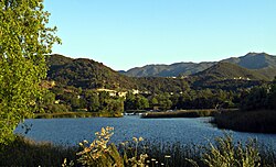
Lake Sherwood and Portero Rd. from Thousand OaksSherwood Dam, Lake Sherwood, and surrounding community
Lake Sherwood was named from being the location for Sherwood Forest in the 1922 film, Robin Hood, starring Douglas Fairbanks.[24] The 1938 film, The Adventures of Robin Hood, starring Errol Flynn, also had a single scene shot on location at "Sherwood Forest".
This page is based on this Wikipedia article Text is available under the CC BY-SA 4.0 license; additional terms may apply. Images, videos and audio are available under their respective licenses.