
Southern California is a geographic and cultural region that generally comprises the southern portion of the U.S. state of California. It includes the Los Angeles metropolitan area as well as the Inland Empire. The region generally contains ten of California's 58 counties: Imperial, Kern, Los Angeles, Orange, Riverside, San Bernardino, San Diego, Santa Barbara, San Luis Obispo and Ventura counties.

State Route 1 (SR 1) is a major north–south state highway that runs along most of the Pacific coastline of the U.S. state of California. At 656 miles (1,056 km), it is the longest state route in California, and the second-longest in the US after Montana Highway 200. SR 1 has several portions designated as either Pacific Coast Highway (PCH), Cabrillo Highway, Shoreline Highway, or Coast Highway. Its southern terminus is at Interstate 5 (I-5) near Dana Point in Orange County and its northern terminus is at U.S. Route 101 (US 101) near Leggett in Mendocino County. SR 1 also at times runs concurrently with US 101, most notably through a 54-mile (87 km) stretch in Ventura and Santa Barbara counties, and across the Golden Gate Bridge.

Ventura County is a county located in the southern part of the U.S. state of California. As of the 2020 census, the population was 843,843. The largest city is Oxnard, and the county seat is the city of Ventura.
Malibu is a beach city in the Santa Monica Mountains region of Los Angeles County, California, about 30 miles (48 km) west of Downtown Los Angeles. It is known for its Mediterranean climate, its strip of beaches stretching 21 miles along the Pacific Ocean coast, and for its longtime status as the home of numerous affluent Hollywood celebrities and executives. Although a high proportion of its residents are entertainment industry figures with million-dollar mansions, Malibu also features several middle- and upper-middle-class neighborhoods. The Pacific Coast Highway traverses the city and has led most residents to settle anywhere from half a mile to within a few hundred yards of it, with some residents living up to one mile away from the beach in areas featuring narrow canyons. As of the 2020 census, the city's population was 10,654.

Oxnard is a city in Ventura County in the U.S. state of California, United States. On California's South Coast, it is the most populous city in Ventura County and the 22nd-most-populous city in California. Incorporated in 1903, Oxnard lies approximately 60 miles (97 km) west of downtown Los Angeles and is part of the larger Greater Los Angeles area.

Ventura, officially named San Buenaventura, is a city in and the county seat of Ventura County, California, United States. It is a coastal city located northwest of Los Angeles. The population was 110,763 at the 2020 census. Ventura is a popular tourist destination, owing to its historic landmarks, beaches, and resorts.

The Santa Monica Mountains are a coastal mountain range in Southern California, next to the Pacific Ocean. It is part of the Transverse Ranges. The Santa Monica Mountains National Recreation Area encompasses this mountain range. Because of its proximity to densely populated regions, it is one of the most visited natural areas in California.

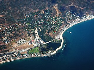
Topanga is an unincorporated community in western Los Angeles County, California, United States. Located in the Santa Monica Mountains, the community exists in Topanga Canyon and the surrounding hills. The narrow southern portion of Topanga at the coast is between the city of Malibu and the Los Angeles neighborhood of Pacific Palisades. As of the 2020 census the population of the Topanga CDP was 8,560. For statistical purposes, the United States Census Bureau has defined Topanga as a census-designated place (CDP). The ZIP code is 90290 and the area code is primarily 310, with 818 only at the north end of the canyon. It is in the 3rd County Supervisorial district.

State Route 23 is a state highway in the U.S. state of California that connects the Pacific coast and the Santa Monica Mountains to the Conejo and Santa Clara River valleys. It runs from Pacific Coast Highway in Malibu in Los Angeles County to Ventura Street in Fillmore in Ventura County.

U.S. Route 101 (US 101) is a major north–south United States Numbered Highway, stretching from Los Angeles, California, to Tumwater, Washington. The California portion of US 101 is one of the last remaining and longest U.S. Routes still active in the state, and the longest highway of any kind in California. US 101 was also one of the original national routes established in 1926. Significant portions of US 101 between the Los Angeles area and the San Francisco Bay Area follow El Camino Real, the commemorative route connecting the former Alta California's 21 missions.

Montaña de Oro is a state park in Central Coastal California, six miles southwest of Morro Bay and two miles south of Los Osos.

The California Coastal Commission (CCC) is a state agency within the California Natural Resources Agency with quasi-judicial control of land and public access along the state's 1,100 miles (1,800 km) of coastline. Its mission as defined in the California Coastal Act is "to protect, conserve, restore, and enhance the environment of the California coastline".

The Oxnard Plain is a large coastal plain in southwest Ventura County, California, United States surrounded by the mountains of the Transverse ranges. The cities of Oxnard, Camarillo, Port Hueneme and much of Ventura as well as the unincorporated communities of Hollywood Beach, El Rio, Saticoy, Silver Strand Beach, and Somis lie within the over 200-square-mile alluvial plain (520 km2). The population within the plain comprises a majority of the western half of the Oxnard-Thousand Oaks-Ventura Metro Area and includes the largest city along the Central Coast of California. The 16.5-mile-long coastline (26.6 km) is among the longest stretches of continuous, linear beaches in the state.
Solimar Beach is within western Ventura city, in Ventura County, California. It is a small Southern California beach and one of the few that still allows dogs on a leash.
Sea Cliff or Seacliff is an unincorporated community in Ventura County, California, United States. The 11-acre (4.5 ha) shoreline group of homes is along U.S. Route 101 and California State Route 1, about 9 miles (14 km) northwest of Ventura. Known as Seacliff Beach Colony, the gated community contains 49 homes. In 1991, the community was evacuated for a week after a train derailment on the rail line between Los Angeles and San Francisco spilled hydrazine in the area. The homeowners reached an agreement in 2005 to purchase the property from the land company, Seacliff Land LLC. They were all previously leasing the land from Seacliff, which owned the property on which their homes were built.
The Rincon Parkway is a portion of California State Route 1 along the north coast of Ventura County, California. This narrow coastal area north of the city of Ventura and south of the Santa Barbara County line is commonly referred to as The Rincon. The automobile route along this portion of coastline opened up in 1913 as the Rincon Causeway or the Rincon Sea Level Road as the first driveable coastal route for motorists traveling between San Francisco and Los Angeles, California. The access road alongside the railroad bed, that cut through the area in 1886, provided the basis for building the Rincon Sea Level Road.
County Line Beach is a beach located in Solromar, California, an unincorporated community of Ventura County. This stretch of sandy beach is easily accessible from the adjacent Pacific Coast Highway. This surf spot popularized by the Beach Boys in their 1963 hit song "Surfin' U.S.A." is administered by the California State Parks' Malibu Sector Coastal Lifeguard Program in addition to Leo Carrillo State Park. The beach lies within the south coast portion of Ventura County amidst a mostly rugged coastline that is some of the most striking and diverse coastal terrain in the County and a backdrop for many televised car scenes. The beach lies at the mouth of a canyon in the Santa Monica Mountains that hugs the shore along the Ventura County's south coast.
The U.S. state of California has instituted numerous conservation programs, policies, laws, reserves and Habitat restoration projects throughout the state to facilitate the health and migration of the western population of the monarch butterfly. The population of western monarchs require very different breeding and overwintering habitat when compared to the eastern population of monarch butterflies. They require specific micro-climatic conditions to survive the winter and they are sensitive to habitat changes at the overwintering sites. The large aggregations of butterflies are seen as the most vulnerable at their overwintering locations along the coast. Many monarch overwintering sites are contained within the "coastal zone"; an area defined by the Coastal Zone Management Act to be 1000 yards inland from the high tide mark. Large number of overwintering sites are outside the coastal zone. There are more than 450 overwintering sites in California.

The Woolsey Fire was a wildfire that burned in Los Angeles and Ventura Counties of the U.S. state of California. The fire ignited on November 8, 2018, and burned 96,949 acres of land. The fire destroyed 1,643 structures, killed three people, and prompted the evacuation of more than 295,000 people. It was one of several fires in California that ignited on the same day, along with the nearby Hill Fire and the destructive Camp Fire in Northern California.


