Lake Viking, Missouri | |
|---|---|
 Lake Viking | |
| Coordinates: 39°55′31″N94°04′09″W / 39.92528°N 94.06917°W | |
| Country | United States |
| State | Missouri |
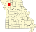
| County | Daviess |
| Area | |
• Total | 8.75 sq mi (22.66 km2) |
| • Land | 7.88 sq mi (20.40 km2) |
| • Water | 0.87 sq mi (2.26 km2) |
| Elevation | 866 ft (264 m) |
| Population (2020) | |
• Total | 486 |
| • Density | 61.7/sq mi (23.82/km2) |
| Time zone | UTC-6 (Central (CST)) |
| • Summer (DST) | UTC-5 (CDT) |
| ZIP code | 64640 |
| Area code | 660 |
| FIPS code | 29-40304 [3] |
| GNIS feature ID | 2587085 [2] |
| Website | lakevikingmo |
Lake Viking is an unincorporated community and census-designated place (CDP) in Daviess County, Missouri, United States. The population was 486 at the 2020 census. [4]