Land O' Lakes, Wisconsin

Last updated
Land O' Lakes, Wisconsin
WIMap-doton-Land O Lakes.png
Location of Land O' Lakes, Wisconsin
Town of Land O Lakes WI 2010 Census Map.png
2010 Town of Land O' Lakes map
Coordinates: 46°9′17″N89°23′7″W / 46.15472°N 89.38528°W / 46.15472; -89.38528 Coordinates: 46°9′17″N89°23′7″W / 46.15472°N 89.38528°W / 46.15472; -89.38528
Country Flag of the United States.svg  United States
State Flag of Wisconsin.svg  Wisconsin
County Vilas
Area
  Total95.3 sq mi (246.8 km2)
  Land83.1 sq mi (215.2 km2)
  Water12.2 sq mi (31.7 km2)
Elevation
[1]
1,755 ft (535 m)
Population
 (2010)
  Total861
  Density10.6/sq mi (4.1/km2)
Time zone UTC-6 (Central (CST))
  Summer (DST) UTC-5 (CDT)
Area code(s) 715 & 534
FIPS code 55-42325 [2]
GNIS feature ID1583525 [1]

Land O' Lakes is a town in Vilas County, Wisconsin, United States. The population was 861 at the 2010 census. The unincorporated community of Land O' Lakes is located in the town.

Contents

History

On January 4, 1907, the Town of State Line was created. [3] On April 28, 1948, the name of the town was changed to the Town of Land O' Lakes. [4]

Geography

The Town of Land o' Lakes is located in north-central Vilas County along the border with the Upper Peninsula of Michigan. The headwaters of a branch of the Ontonagon River is located in the town at the Cisco Chain of lakes, and the upper part of the Wisconsin River flows through the town, with the headwaters being located just to the east at Lac Vieux Desert. According to the United States Census Bureau, the town has a total area of 95.3 square miles (246.9 km2) of which 83.1 square miles (215.2 km2) is land and 12.2 square miles (31.7 km2) (12.83%) is water. The town is very long and narrow, with the town center, government offices, and most services located in the unincorporated community of Land o' Lakes at the far eastern end of the town.

Demographics

At the 2010 census, [2] there were 861 people, 433 households and 264 families residing in the town. The population density was 10.6 per square mile (4.1/km2). There were 1,337 housing units at an average density of 16.1 per square mile (6.2/km2). The racial makeup of the town was 98.41% White, 0.68% Native American, 0.34% Asian, 0.45% from other races, and 0.11% from two or more races. Hispanic or Latino of any race were 0.45% of the population.

There were 433 households, of which 14.5% had children under the age of 18 living with them, 48.5% were married couples living together, 5.3% had a female householder with no husband present, and 43.6% were non-families. 37.2% of all households were made up of individuals, and 16.0% had someone living alone who was 65 years of age or older. The average household size was 1.99 and the average family size was 2.57.

Age distribution was 13.5% under the age of 18, 7.0% from 15 to 24, 15.2% from 25 to 44, 38.3% from 45 to 64, and 28.9% who were 65 years of age or older. The median age was 54 years. For every 100 males there were 88.4 females.

The median household income was $29,792, and the median family income was $40,938. Males had a median income of $30,357 versus $21,250 for females. The per capita income for the town was $18,765. About 5.5% of families and 7.5% of the population were below the poverty line, including 3.2% of those under age 18 and 5.9% of those age 65 or over.

Education

Most of Land o' Lakes is part of the Northland Pines School District and there is an elementary school that serves students from kindergarten to fifth grade in the unincorporated community of Land o' Lakes. Students travel to the nearby city of Eagle River, Wisconsin, for middle school and high school. Conserve School, a private semester school for high school juniors that focuses on environmental stewardship and outdoor activities, is located on the shore of Black Oak Lake. Some students in far southwestern parts of the Town attend North Lakeland Elementary School and Lakeland Union High School.

Transportation

Roads and highways

The Town of Land o' Lakes is served by USH 45, STH 32, and three Vilas County Trunk Highways. USH 45 runs north-south in the eastern part of the town, serving the unincorporated community of Land o' Lakes. It proceeds northward into the Upper Peninsula of Michigan to Watersmeet and a connection to US 2. USH 45 proceeds southward through Conover to Eagle River and points south. STH 32 begins at the Michigan border and proceeds southward concurrently with USH 45. CTH B runs the length of the town and serves as the main street of the unincorporated community of Land o' Lakes. It proceeds west to Presque Isle and a connection with M-64. CTH B meets CTH M - which provides access to Boulder Junction. CTH S proceeds south from a junction with CTH B approximately 5 miles from the unincorporated community of Land o' Lakes and serves the areas around Clair and Joyce Lakes before entering the Town of Conover. CTH E proceeds eastward from a junction with USH45/STH 32 in the southeast corner of the town and provides access to Lac Vieux Desert and Phelps, where it meets STH 17. Thousand Island Lake Road - a town road, provides a southern entrance to the Sylvania Wilderness.

Airport

Land O' Lakes is served by Kings Land O' Lakes Airport (KLNL). Located one mile southeast of the town, the airport handles approximately 8,000 operations per year, with roughly 99% general aviation and 1% air taxi. The airport has a 4,001 foot asphalt runway with approved GPS approaches (Runway 14-32). [5]

Notable residents

Climate

The climate is described as Humid Continental by the Köppen Climate System, abbreviated as Dfb. [6]

Climate data for Land O' Lakes, Wisconsin
MonthJanFebMarAprMayJunJulAugSepOctNovDecYear
Average high °C (°F)−7
(19)
−7
(20)
1
(34)
9
(49)
18
(64)
24
(75)
26
(78)
23
(74)
19
(67)
12
(54)
3
(37)
−4
(25)
10
(50)
Average low °C (°F)−20
(−4)
−19
(−2)
−13
(8)
−4
(25)
2
(36)
8
(47)
11
(51)
9
(48)
5
(41)
1
(33)
−7
(19)
−14
(6)
−3
(26)
Average precipitation mm (inches)36
(1.4)
28
(1.1)
48
(1.9)
64
(2.5)
89
(3.5)
110
(4.2)
110
(4.5)
100
(4)
94
(3.7)
76
(3)
56
(2.2)
41
(1.6)
850
(33.6)
Source: Weatherbase [7]

Related Research Articles

Taylor County, Wisconsin U.S. county in Wisconsin

Taylor County is a county in the U.S. state of Wisconsin. As of the 2010 census, the population was 20,689. Its county seat is Medford.

Iron County, Wisconsin U.S. county in Wisconsin

Iron County is a county located in the U.S. state of Wisconsin. As of the 2010 census, the population was 5,916, making it the third-least populous county in Wisconsin. Its county seat is Hurley. It was named for the valuable iron ore found within its borders.

Gingles, Wisconsin Town in Wisconsin, United States

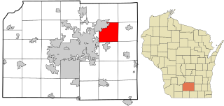
Gingles is a town in Ashland County in the U.S. state of Wisconsin. The population was 778 at the 2010 census. The unincorporated community of White River is located in the town.

West Kewaunee, Wisconsin Town in Wisconsin, United States

West Kewaunee is a town in Kewaunee County, Wisconsin, United States. The population was 1,296 at the 2010 census. The unincorporated communities of Birchwood, East Krok, and Krok are located in the town.

Reid, Wisconsin Town in Wisconsin, United States

Reid is a town in Marathon County, Wisconsin, United States. It is part of the Wausau, WI Metropolitan Statistical Area. The population was 1,215 at the 2010 census. The unincorporated communities of Little Eau Claire and Pike Lake are located in the town. The unincorporated community of Bevent is located partially in the town.

Lake Tomahawk, Wisconsin Town in Wisconsin, United States

Lake Tomahawk is a town in Oneida County, Wisconsin, United States named for the adjacent freshwater lake of the same name. The population was 1,160 at the 2000 census. The census-designated place of Lake Tomahawk and the unincorporated community of Sunflower are located in the town.

Sugar Camp, Wisconsin Town in Wisconsin, United States

Sugar Camp is a town in Oneida County, Wisconsin, United States. The population was 1,694 at the 2010 census. The unincorporated community of Sugar Camp is located in the town

Boulder Junction, Wisconsin Town in Wisconsin, United States

Boulder Junction is a town in Vilas County, Wisconsin, United States. The population was 958 at the 2000 census.

Conover, Wisconsin Town in Wisconsin, United States

Conover is a town in Vilas County, Wisconsin, United States. The population was 1,235 at the 2010 census. The unincorporated community of Conover is located in the town.

Eagle River, Wisconsin City in Wisconsin, United States

Eagle River is a city in Vilas County, Wisconsin, United States. The population was 1,398 at the 2010 census. It is the county seat of Vilas County. Because of the many lakes in the area, the city is a popular vacation and retirement destination. The area contains many condominiums, seasonal vacation homes, and hunting cabins.

Phelps, Wisconsin Town in Wisconsin, United States

Phelps is a town in Vilas County, Wisconsin, United States. The population was 1,350 at the 2000 census. The unincorporated community of Phelps is located in the town.

Plum Lake, Wisconsin Town in Wisconsin, United States

Plum Lake is a town in Vilas County, Wisconsin, United States. The population was 486 at the 2000 census. The census-designated place of Sayner and the unincorporated community of Star Lake are located in the town.

Presque Isle, Wisconsin Town in Wisconsin, United States

Presque Isle is a town in Vilas County, Wisconsin, United States. The population was 616 at the 2010 census. The unincorporated communities of Presque Isle and Katinka Village are located in the town.

Winchester, Vilas County, Wisconsin Town in Wisconsin, United States

Winchester is a town in Vilas County, Wisconsin, United States. The population was 383 at the 2010 census. The unincorporated community of Winchester - locally known as the "Winchester Townsite" - is located in the town.

Dayton, Waupaca County, Wisconsin Town in Wisconsin, United States

Dayton is a town in Waupaca County, Wisconsin, United States. The population was 2,734 at the 2000 census. The unincorporated communities of Little Hope, Parfreyville, and Rural are located in the town. The census-designated place of Chain O' Lake is also partially located within the town.

Cottage Grove (town), Wisconsin Town in Wisconsin, United States

Cottage Grove is a town in Dane County, Wisconsin. As of the 2000 census, the town had a population of 3,839. The Village of Cottage Grove is located within the town. The unincorporated communities of Door Creek, Nora, and Vilas are also located in the town. The unincorporated community of Hoffman Corners is also located partially in the town.

Sun Prairie (town), Wisconsin Town in Wisconsin, United States

Sun Prairie is a town in Dane County, Wisconsin, United States. The population was 29,364 at the 2010 census. The City of Sun Prairie is located partially within the town. The unincorporated communities of Pierceville and Schey Acres are also located in the town.

Merrimac is a town in Sauk County, Wisconsin, United States. The population was 868 at the 2000 census. The Village of Merrimac is located within the town. The unincorporated community of Moon Valley is located in the town. The census-designated place of Lake Wisconsin is also located partially in the town.

Star Prairie is a town in St. Croix County, Wisconsin, United States. The population was 2,944 at the 2000 census. The Village of Star Prairie is located on the eastern boundary of the town. The unincorporated communities of Huntington and Johannesburg are located in the town.

Merton (town), Wisconsin Town in Wisconsin, United States

Merton is a town in Waukesha County, Wisconsin, United States. The population was 7,988 at the 2000 census. The town surrounds the villages of Chenequa and Merton. The unincorporated communities of Camp Whitcomb, Monches, and North Lake are in the town and the unincorporated community of Stone Bank is partially in the town. The pioneer Swedish-American settlement of New Upsala was also at one time located within Merton.

References

  1. 1 2 "US Board on Geographic Names". United States Geological Survey. 2007-10-25. Retrieved 2008-01-31.
  2. 1 2 "U.S. Census website". United States Census Bureau . Retrieved 2008-01-31.
  3. "State Line, Town of, Vilas Co". Wisconsinhistory.org. Archived from the original on 2007-08-27. Retrieved 2011-10-14.
  4. "Land O' Lakes, Town of, Vilas Co". Wisconsinhistory.org. 1948-04-20. Archived from the original on 2006-01-13. Retrieved 2011-10-14.
  5. http://www.airnav.com/airports/KLNL
  6. Climate Summary for Land O' Lakes, Wisconsin
  7. "Weatherbase.com". Weatherbase. 2013. Retrieved on August 27, 2013.