Lares | |
---|---|
Barrio | |
Coordinates: 18°17′39″N66°50′39″W / 18.294295°N 66.844046°W [1] | |
Commonwealth | Puerto Rico |
Municipality | Lares |
Area | |
• Total | 4.94 sq mi (12.8 km2) |
• Land | 4.94 sq mi (12.8 km2) |
• Water | 0 sq mi (0 km2) |
Elevation | 1,447 ft (441 m) |
Population (2010) | |
• Total | 3,405 |
• Density | 689.3/sq mi (266.1/km2) |
Source: 2010 Census | |
Time zone | UTC−4 (AST) |
Lares is a barrio in the municipality of Lares, Puerto Rico. Its population in 2010 was 3,405. [3] [4] [5]
Lares was in Spain's gazetteers [6] until Puerto Rico was ceded by Spain in the aftermath of the Spanish–American War under the terms of the Treaty of Paris of 1898 and became an unincorporated territory of the United States. In 1899, the United States Department of War conducted a census of Puerto Rico finding that the population of Lares barrio was 1,954. [7]
Census | Pop. | Note | %± |
---|---|---|---|
1900 | 1,954 | — | |
1910 | 2,256 | 15.5% | |
1920 | 2,343 | 3.9% | |
1930 | 2,824 | 20.5% | |
1940 | 3,141 | 11.2% | |
1950 | 2,966 | −5.6% | |
1960 | 2,149 | −27.5% | |
1970 | 0 | −100.0% | |
1980 | 3,351 | — | |
1990 | 3,458 | 3.2% | |
2000 | 3,807 | 10.1% | |
2010 | 3,405 | −10.6% | |
U.S. Decennial Census 1899 (shown as 1900) [8] 1910-1930 [9] 1930-1950 [10] 1980-2000 [11] 2010 [12] |
Barrios (which are, in contemporary times, roughly comparable to minor civil divisions) [13] and subbarrios, [14] in turn, are further subdivided into smaller local populated place areas/units called sectores (sectors in English). The types of sectores may vary, from normally sector to urbanización to reparto to barriada to residencial, among others. [15] [16] [17]
The following sectors are in Lares barrio: [18]
Camino Obispo, Cuesta Mayía, El 25, La Sabana Sumidero, Las Casetas Capotillo, Las Tres Marías, Sector Jobos López, Sector Jobos Mario, Sector La Sierra Tatí, Sector Las Minas, Sector Los Muros, Sector Manolo Toledo, Sector Miján Parcelas Miría, Sector Palmarllano, Sector Sierra Miría, Tramo Carretera 111, Tramo Carretera 134 , and Urbanización Villa Palmira.
Facilidades Recreativas Edelmiro “Mirito” Jiménez is a recreational facility and mini baseball stadium named after Edelmiro “Mirito” Jiménez, [19] located on PR-111 in Lares barrio. [20]
Candelaria is a barrio in the municipality of Toa Baja, Puerto Rico. Its population in 2010 was 23,343.
Medianía Baja is a barrio in the municipality of Loíza, Puerto Rico. Its population in 2010 was 8,781.
Vacas is a barrio in the municipality of Villalba, Puerto Rico. Its population in 2010 was 4,049.
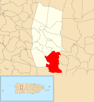
Bartolo is a barrio in the municipality of Lares, Puerto Rico. Its population in 2010 was 2,035. Bartolo is on the southeastern border of Lares and Adjuntas.
Buenos Aires is a barrio in the municipality of Lares, Puerto Rico. Its population in 2010 was 2,291.
Callejones is a barrio in the municipality of Lares, Puerto Rico. Its population in 2010 was 4,575. Machos Cave and Pajita Cave are located in Callejones.
La Torre is a barrio in the municipality of Lares, Puerto Rico. Its population in 2010 was 1,574.
Pezuela is a barrio in the municipality of Lares, Puerto Rico. Its population in 2010 was 474. The barrio is divided into about 8 sectors. The barrio has been prone to landslides since Hurricane Maria struck in 2017.
Piletas is a barrio in the municipality of Lares, Puerto Rico. Its population in 2010 was 5,671.
Lares barrio-pueblo is a barrio and the administrative center (seat) of Lares, a municipality of Puerto Rico. Its population in 2010 was 2,690.
Río Prieto is a barrio in the municipality of Lares, Puerto Rico. Its population in 2010 was 567.
Piedras Blancas is a barrio in the municipality of Aguada, Puerto Rico. Its population in 2010 was 4,635.
Pueblo is a barrio in the municipality of Lares, Puerto Rico. Its population in 2010 was 4,838.
Espino is a barrio in the municipality of Lares, Puerto Rico. Its population in 2010 was 1,695.
Cocos is a barrio in the municipality of Quebradillas, Puerto Rico. Its population in 2010 was 4,889.
Jiménez is a barrio in the municipality of Río Grande, Puerto Rico. Its population in 2010 was 2,925.
Damián Abajo is a barrio in the municipality of Orocovis, Puerto Rico. Its population in 2010 was 754.
Sud is a barrio in the municipality of Cidra, Puerto Rico. Its population in 2010 was 3,714.
Mata de Cañas is a barrio in the municipality of Orocovis, Puerto Rico. Its population in 2010 was 538.