Leicester urban area

Last updated

The Leicester Urban Area or Leicester Built Up Area (2011 onwards) is an urban agglomeration defined by the Office of National Statistics (ONS), centred on the City of Leicester in the East Midlands, England. With a population of 559,017 at the time of the 2021 census, [1] increased from 508,916 at the time of the 2011 census, the Built Up Area is the eleventh largest in England and thirteenth largest in the United Kingdom. It comprises Leicester itself and its suburbs, all of which are contiguous with or situated in close proximity to the city.

Contents

As at 2011 the Leicester Urban Area was home to 51.8% of the total population of Leicestershire [2] (2001: 48.5%). A 2017 quote from the Leicester City Council website states that "The Greater Leicester urban area is one of the fastest growing in the country, with a population of about 650,000, of which 350,000 live within the city council area" [3] .

Analysis: 2011

Leicester built-up area in 2011. Directly contiguous outer suburbs now merged into Leicester. Syston now a subdivision; Ratby removed completely; new south western areas included.
.mw-parser-output .legend{page-break-inside:avoid;break-inside:avoid-column}.mw-parser-output .legend-color{display:inline-block;min-width:1.25em;height:1.25em;line-height:1.25;margin:1px 0;text-align:center;border:1px solid black;background-color:transparent;color:black}.mw-parser-output .legend-text{}
Leicester subdivision
Other subdivisions
City of Leicester unitary authority boundary Leicester-BUA-2011.jpg
Leicester built-up area in 2011. Directly contiguous outer suburbs now merged into Leicester. Syston now a subdivision; Ratby removed completely; new south western areas included.
  Leicester subdivision
  Other subdivisions
  City of Leicester unitary authority boundary

Leicester Built-up Area
2011 Census [4]

Urban subdivisionPopulation
Leicester ONS

City &
inner suburbs
in detail
 
City
329,283
Leicester UNITARY 329,839
*less Ashton Green556
 
Inner suburbs
114,477
Wigston 32,321
Oadby 23,849
Braunstone Town 16,850
Thurmaston 9,668
Glenfield 9,109
Leicester Forest East 6,719
Glen Parva 6,189
Kirby Muxloe 4,667
Thurnby and Bushby 3,301
Scraptoft 1,804
City &
inner suburbs

443,760

Narborough / Enderby 12,996Outer suburbs

65,156

Syston 12,804
Blaby / Whetstone 12,760
Birstall 12,216
Groby 6,782
Cosby 3,506
Queniborough 2,326
Littlethorpe 1,766
Total508,916
Change % from 2001Increase2.svg 15.3%

Analysis: 2001

Leicester urban area in 2001. Northern Beaumont Leys included.
Leicester subdivision
Other subdivisions LeicesterUrbanArea.svg
Leicester urban area in 2001. Northern Beaumont Leys included.
  Leicester subdivision
  Other subdivisions

Leicester Urban Area
2001 Census [5]

Urban subdivisionPopulation
Leicester ONS

City &
inner suburbs
in detail
 
City
273,758
Leicester UNITARY 279,921
*less Beaumont Leys
(see below)
5,579
*less Ashton Green584
 
Inner suburbs
56,816
Braunstone Town 14,981
Syston 11,608
Thurmaston 8,945
Glenfield 9,193
Glen Parva 5,902
Thurnby and Bushby 3,147
Scraptoft 1,521
Leicester Forest East 1,519
City &
inner suburbs

330,574

Wigston 33,116Outer suburbs

110,639

Oadby 22,679
Blaby / Whetstone 12,263
Birstall 11,480
Kirby Muxloe 9,500
Groby 6,256
Beaumont Leys 5,579
Ratby 3,862
Cosby 3,647
Queniborough 2,257
Total441,213
Change % from 1991Increase2.svg 5.8%

Analysis: 1991

Leicester urban area in 1991, with newly added southern subdivisions.
Leicester subdivision
Other subdivisions Leicester Urban Area 1991.svg
Leicester urban area in 1991, with newly added southern subdivisions.
  Leicester subdivision
  Other subdivisions

Leicester Urban Area
1991 Census [6]

Urban subdivisionPopulation
Leicester ONS City &
inner suburbs

318,518

Wigston 32,864Outer suburbs

98,083

Oadby 18,538
Birstall 11,770
Kirby Muxloe 7,780
Groby 7,183
Blaby 6,538
Whetstone 4,032
Ratby 3,601
Cosby 3,390
Queniborough 2,387
Total416,601
Change % from 1981Increase2.svg 3%

Analysis: 1981

Leicester urban area in 1981, showing shaded 'outer suburbs' subdivisions. The small text lists 'inner suburbs' within the Leicester ONS subdivision, but outside the unitary authority (city council) area.
Leicester subdivision
Other subdivisions Leicester Urban Area 1981.svg
Leicester urban area in 1981, showing shaded 'outer suburbs' subdivisions. The small text lists 'inner suburbs' within the Leicester ONS subdivision, but outside the unitary authority (city council) area.
  Leicester subdivision
  Other subdivisions

Leicester Urban Area
1981 Census [7]

Urban subdivisionPopulation
Leicester ONS City &
inner suburbs

324,394

Wigston 32,373Outer suburbs

80,008

Oadby 18,331
Birstall 12,519
Kirby Muxloe 6,896
Groby 4,689
Ratby 3,095
Queniborough 2,105
Total404,402


Analysis: Notes

The Leicester ONS sub-totals are explained with reference to the following:

The Kirby Muxloe figures up to 2001 includes the portion of Leicester Forest East which is to the west of the M1 motorway. The eastern section is part of the Leicester ONS subdivision, and is listed separately in the 2001 table.

Although Stoughton is shown as a small leg of the urban area, its figures are not counted.

52°38′N1°08′W / 52.63°N 1.13°W / 52.63; -1.13

See also

Related Research Articles

<span class="mw-page-title-main">Leicester</span> City and unitary authority area in England

Leicester is a city, unitary authority area, unparished area and the county town of Leicestershire in the East Midlands of England. It is the largest city in the East Midlands. Its population was 368,600 in 2021, increased by 38,800 from around 329,800 in 2011. The greater Leicester urban area had a population of 559,017 in 2021, making it the 11th most populous in England, and the 13th most populous in the United Kingdom.

<span class="mw-page-title-main">Leicestershire</span> County of England

Leicestershire is a ceremonial county in the East Midlands of England. It is bordered by Derbyshire, Nottinghamshire, and Lincolnshire to the north, Rutland to the east, Northamptonshire to the south-east, Warwickshire to the south-west, and Staffordshire to the west. The city of Leicester is the largest settlement and the county town.

<span class="mw-page-title-main">Demography of England</span> Social makeup of England

The demography of England has since 1801 been measured by the decennial national census, and is marked by centuries of population growth and urbanization. Due to the lack of authoritative contemporary sources, estimates of the population of England for dates prior to the first census in 1801 vary considerably. The population of England at the 2021 census was 56,489,800.

<span class="mw-page-title-main">West Midlands conurbation</span> Conurbation in England

The West Midlands conurbation is the large conurbation in the West Midlands region of England. The area consists of two cities and numerous towns: to the east, the city of Birmingham, along with adjacent towns of Solihull and Sutton Coldfield; and to the west, the city of Wolverhampton and the area called the Black Country, containing the towns of Dudley, Walsall, West Bromwich, Oldbury, Willenhall, Bilston, Darlaston, Tipton, Smethwick, Wednesbury, Rowley Regis, Stourbridge and Halesowen.

<span class="mw-page-title-main">Audenshaw</span> Market Town in Greater Manchester, England

Audenshaw is a market town in Tameside, Greater Manchester, England, 4.9 miles (7.9 km) east of Manchester. Historically part of Lancashire, in 2011 it had a population of 11,419.

<span class="mw-page-title-main">Urban area</span> Human settlement with high population density and infrastructure of built environment

An urban area, built-up area or urban agglomeration is a human settlement with a high population density and an infrastructure of built environment. This is the core of a metropolitan statistical area in the United States, if it contains a population of more than 50,000.

<span class="mw-page-title-main">Nottingham Urban Area</span> Area of land in and around Nottingham, England

The Nottingham Built-up Area (BUA), Nottingham Urban Area, or Greater Nottingham is an area of land defined by the Office for National Statistics as which is built upon, with nearby areas linked if within 200 metres. It consists of the city of Nottingham and the adjoining urban areas of Nottinghamshire and Derbyshire, in the East Midlands of England. It had a total population of 729,977 at the time of the 2011 census. This was an increase of almost 10% since the 2001 census recorded population of 666,358, due to population increases, reductions and several new sub-divisions.

<span class="mw-page-title-main">Bosworth (UK Parliament constituency)</span> UK Parliament constituency in England since 1885

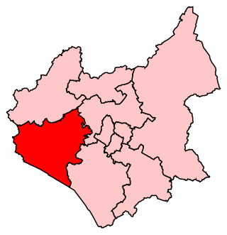
Bosworth is a constituency represented in the House of Commons of the UK Parliament since 2019 by Luke Evans, a Conservative.

<span class="mw-page-title-main">Leicester West (UK Parliament constituency)</span> Parliamentary constituency in the United Kingdom, 1974 onwards

Leicester West is a constituency represented in the House of Commons of the UK Parliament since 2010 by Liz Kendall of the Labour Party. Along with the other two Leicester seats, it was held by Labour at the 2017 general election. Since its creation in 1918 the seat has sided with parties from the left wing of politics.

<span class="mw-page-title-main">Beaumont Leys</span> Suburb and electoral ward in north-western Leicester, England

The CV postcode area, also known as the Coventry postcode area, is a group of 24 postcode districts in central England, within eleven post towns. These cover the eastern part of the West Midlands county, most of Warwickshire, a part of west Leicestershire and a very small part of Northamptonshire.

<span class="mw-page-title-main">Greater Manchester Built-up Area</span> Conurbation in England

The Greater Manchester Built-up Area is an area of land defined by the Office for National Statistics (ONS), consisting of the large conurbation that encompasses the urban element of the city of Manchester and the metropolitan area that forms much of Greater Manchester in North West England. According to the United Kingdom Census 2011, the Greater Manchester Built-up Area has a population of 2,553,379 making it the second most populous conurbation in the United Kingdom after the Greater London Built-up Area. This was an increase of 14% from the population recorded at the United Kingdom Census 2001 of 2,240,230, when it was known as the Greater Manchester Urban Area.

<span class="mw-page-title-main">Liverpool Built-up Area</span> Human settlement in United Kingdom

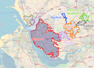
The Liverpool Built-up Area is a term used by the Office for National Statistics (ONS) to denote the urban area around Liverpool in England, to the east of the River Mersey. The contiguous built-up area extends beyond the area administered by Liverpool City Council into adjoining local authority areas, particularly parts of Sefton and Knowsley. As defined by ONS, the area extends as far east as St Helens, Haydock, and Ashton-in-Makerfield in Greater Manchester.

<span class="mw-page-title-main">Greater London Built-up Area</span> Conurbation in south-east England

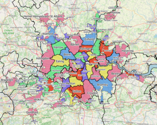
The Greater London Built-up Area, or Greater London Urban Area, is a conurbation in south-east England that constitutes the continuous urban sprawl of London, and includes surrounding adjacent urban towns as defined by the Office for National Statistics. It is the largest urban area in the United Kingdom with a population of 9,787,426 in 2011.

<span class="mw-page-title-main">Wigan urban area</span>

The Wigan Urban Area is an area of land defined by the Office for National Statistics consisting of the built-up, or 'urbanised' area containing Wigan in Greater Manchester and Skelmersdale in West Lancashire.

<span class="mw-page-title-main">Milton Keynes urban area</span> Settlement in Buckinghamshire, England

The Milton Keynes urban area or Milton Keynes Built-up Area is a designation established by the United Kingdom's Office for National Statistics. Milton Keynes has no statutory boundary: the 1967 designated area only determined the area assigned to the Milton Keynes Development Corporation for development. The wider urban area outside that designation includes Newport Pagnell and Woburn Sands as well as Aspley Guise (Bedfordshire) and part of Stoke Hammond civil parish.

<span class="mw-page-title-main">Demography of Leicester</span>

Leicester, England is an ethnically and culturally diverse city. It is the thirteenth most populous city in the United Kingdom.

References

  1. "UNITED KINGDOM: Urban Areas in England". City Population. Retrieved 26 April 2023.
  2. Combined city and county
  3. 'Exhibitions give information about Local Plan' (Published on 11 September 2017)
  4. "KS101EW (Usual resident population) - Nomis - Official Labour Market Statistics". www.nomisweb.co.uk. Retrieved 2017-06-17.
  5. "United Kingdom: Urban Areas 2001". ONS. Retrieved 11 November 2016.
  6. "United Kingdom: Urban Areas 1991". ONS. Retrieved 21 July 2017.
  7. 1981 Key Statistics for Urban Areas: The Midlands Table 1, Office for National Statistics, 1981.
  8. "Ashton Green development project". www.leicester.gov.uk.