OC Transpo is the organisation that operates and plans public transport in the city of Ottawa, Ontario, Canada. OC Transpo runs bus rapid transit, light rail, conventional bus routes, and door-to-door paratransit.

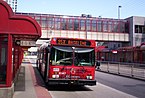
The Transitway is a bus rapid transit (BRT) network operated by OC Transpo in Ottawa, Ontario, Canada. It comprises a series of bus-only roadways and reserved lanes on city streets and highways. The dedicated busways ensure that buses and emergency vehicles on the Transitway rarely intersect directly with regular traffic, making it possible to run quickly and consistently, even during rush hour traffic. OC Transpo operates a network of rapid routes which use the Transitway to connect communities with the O-Train light rail system. Additional bus routes also use segments of the Transitway.

Barrhaven is a suburb of Ottawa, Ontario, Canada. It is located about 17 km (11 mi) southwest of the city's downtown core. Prior to amalgamation with Ottawa in 2001, Barrhaven was part of the City of Nepean. Its population as of the Canada 2021 Census was 103,234.

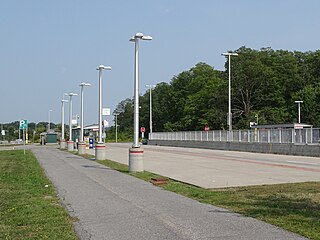
Greenboro is a transitway stop and future O-Train Trillium Line station in Ottawa, Ontario, Canada. It is located at Bank Street and Johnston Road at the north end of the South Keys shopping complex. The station has a 678-space paid park and ride lot. The bus terminus was opened with the southern transitway on September 2, 1995.

The Trillium Line, also called O-Train Line 2, is a diesel light rail transit (DLRT) service in Ottawa, Ontario, Canada, operated by OC Transpo. The line has been closed since May 2020 for service expansion.

South Keys station is the southernmost station of the Southeast Transitway in Ottawa. The station is located in the South Keys neighbourhood, behind the south end of the South Keys Shopping Centre, and between Bank Street and the Airport Parkway. The Transitway station was opened for bus service on September 2, 1995.
Riverside South is a suburban community in Gloucester-South Nepean Ward in the south end of the city of Ottawa, Ontario, Canada, just southwest of Ottawa Macdonald–Cartier International Airport. Prior to amalgamation in 2001, the area was located in the city of Gloucester. Its population, according to the Canada 2021 Census, was 19,802.
Leitrim is a dispersed rural community in the South Gloucester section of Ottawa, Ontario, Canada, and is named for the Irish County Leitrim. The area comprises the rapidly growing Findlay Creek suburban neighbourhood.

OC Transpo is a public transit commission that operates 170 bus routes, two light rail lines, and a paratransit system in Ottawa and the National Capital Region.

Marketplace is a Southwest Transitway station in the Barrhaven neighbourhood of Ottawa, Ontario, Canada. The station is located at the Chapman Mills Marketplace shopping centre, an extensive commercial zone which contains big-box stores and department stores.

Findlay Creek is a suburban neighbourhood in Riverside South-Findlay Creek Ward in the south end of Ottawa, Ontario, Canada. According to the 2021 Canadian Census, the population of the community was 14,089 and there were 4,395 dwellings.

Fallowfield station or Fallowfield Train Station is an inter-city passenger railway station and bus rapid transit station located at 3347 Fallowfield Road in the suburban neighbourhood of Barrhaven in Ottawa, Ontario, Canada.

Riverview is an OC Transpo transit station located in the Riverside South community in Ottawa, Ontario. The station is located south of Earl Armstrong Road east of River Road.
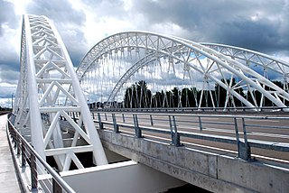
The Vimy Memorial Bridge is a bridge in Ottawa, Ontario, Canada. Completed in 2014, it crosses the Rideau River, connecting Strandherd Drive in Barrhaven and Earl Armstrong Road in Riverside South. The bridge was the 2015 winner of the Gustav Lindenthal Medal. It is named after the Battle of Vimy Ridge, as suggested by two Royal Canadian Legions in Ottawa.

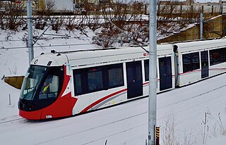
The Confederation Line, also called O-Train Line 1, is a light rail line operated by OC Transpo in Ottawa, Ontario, Canada, as part of the city's O-Train light rail system. It opened on September 14, 2019, and is O-Train's second line. It operates on an east–west route, with a segment under Queen Street in the downtown core, complementing the north–south Trillium Line that operates to the west of the downtown core. Using light rail rolling stock and technology, the Confederation Line is completely grade separated.
Nepean Woods station is located in the Ottawa, Ontario, Canada suburb of Barrhaven, and is on the Southwest Transitway which is served by OC Transpo buses. Located near the intersection of Woodroffe Avenue and Strandherd Drive in southern Nepean, it was the westerly terminus of most trips of rapid-transit route 74, formerly numbered route 94. It is also the site of a park and ride lot for residents of Barrhaven, which opened on 24 February 2014.
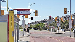
Beatrice station is a south-west Transitway station located in the Ottawa, Ontario, Canada, suburb of Barrhaven.

The O-Train is a light rail rapid transit system in Ottawa, Ontario, Canada, operated by OC Transpo. The system consists of two lines: the electrically-operated Confederation Line, running east to west, and the diesel-operated Trillium Line, running north to south. Both lines are currently being extended as part of the Stage 2 project, with new segments being phased in between 2025 and 2027.

Limebank is an under construction terminal station on the Trillium Line in Ottawa, Ontario. When constructed, it will be the southern terminus of the Stage 2 O-Train expansion and is scheduled for completion in 2025. The station will be elevated with two side platforms and is located southwest of the intersection of Limebank and Earl Armstrong roads. OC Transpo Rapid bus routes 74 and 99 will connect to this station once revenue service begins in 2025.