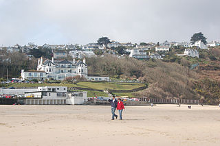
Carbis Bay is a seaside resort and village in Cornwall, England. It lies 1 mile (1.6 km) southeast of St Ives, on the western coast of St Ives Bay, on the Atlantic coast. The South West Coast Path passes above the beach.

Towednack is a churchtown and civil parish in Cornwall, England, United Kingdom. The parish is bounded by those of Zennor in the west, Gulval in the south, Ludgvan in the west and south, and St Ives and the Atlantic Ocean in the north and east. The church is about two miles (3 km) from St Ives and six miles (10 km) from Penzance.

The St Ives Bay Line is a 4.25 miles (6.84 km) railway line from St Erth to St Ives in Cornwall, England, United Kingdom. It was opened in 1877, the last new 7 ft broad gauge passenger railway to be constructed in the country. Converted to standard gauge in 1892, it continues to operate as a community railway, carrying tourists as well as local passengers. It has five stations including the junction with the Cornish Main Line at St Erth.

Lelant is a village in west Cornwall, England, UK. It is on the west side of the Hayle Estuary, about 2+1⁄2 miles (4.0 km) southeast of St Ives and one mile (1.6 km) west of Hayle. The village is part of St Ives civil parish, the Lelant and Carbis Bay ward on Cornwall Council, and also the St Ives Parliamentary constituency. The birth, marriage, and death registration district is Penzance. Its population at the 2011 census was 3,892 The South West Coast Path, which follows the coast of south west England from Somerset to Dorset passes through Lelant, along the estuary and above Porth Kidney Sands.

The River Hayle is a small river in West Cornwall, England, United Kingdom which issues into St Ives Bay at Hayle on Cornwall's Atlantic coast.
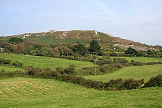
Trencrom Hill is a prominent hill fort, owned by the National Trust, near Lelant, Cornwall. It is crowned by an univallate Neolithic tor enclosure and was re-used as a hillfort in the Iron Age. Cairns or hut circles can be seen in the level area enclosed by the stone and earth banks. The hill overlooks the Hayle Estuary and river, and Mount's Bay and St Michael's Mount can be seen to the south. The hill was recorded as Torcrobm in 1758 which is derived from Cornish "torr crobm", i.e. 'hunched bulge'.

United Downs is a hamlet in the parish of Gwennap, Cornwall, England, UK.
Gwinear Downs is a hamlet in the parish of Crowan, Cornwall, England. It is in the civil parish of Camborne.

Helston Water is a hamlet northwest of Carnon Downs in Cornwall, England. It is in the civil parish of Kea

Higher Downs is a moorland in the parish of Morvah in west Cornwall, England.
Mithian Downs is an area south of Mithian in west Cornwall, England.

Mountjoy is a hamlet in the civil parish of Colan in Cornwall, England. It is on the A392 road, east of Quintrell Downs.

Nancegollan is a village in the civil parish of Crowan in west Cornwall, England. Nancegollan is on the B3303 road and south-east of Leedstown.

New Downs is a farm near Camborne and St Agnes in Cornwall, England.
Perran Downs is a hamlet near Perranuthnoe, Goldsithney and St Hilary in Cornwall, England. It is close by to the 13th-century St Hilary Church.
Mulberry Downs Quarry is a disused opencast tin mine in Cornwall, England, UK. Today the site is described as a 'chasm' being a steep or sheer-sided pit 700 foot (210 m) long and up to 100 foot (30 m) deep, and the quarry and immediate surroundings are heavily wooded. The quarry was designated as a Site of Special Scientific Interest (SSSI) in 1973 for its geological interest.

Castle Downs is a dome-shaped hill, 216 metres (709 ft) high, located in mid Cornwall, UK. There is a major hillfort, Castle an Dinas, on the summit and extensive and panoramic views across the county to both north and south coasts.

St Michael’s Way is a waymarked long-distance footpath in Cornwall. It runs for 12.5 miles (20 km) from Lelant on Cornwall’s north coast to St Michael’s Mount on the south coast.


