Libertyville, Indiana

Last updated

Libertyville, Indiana
Map of Indiana highlighting Vigo County.svg
Vigo County's location in Indiana
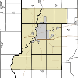
Map of Vigo County Indiana Townships.svg
Red pog.svg
Libertyville
Coordinates: 39°36′10″N87°31′07″W / 39.60278°N 87.51861°W / 39.60278; -87.51861
Country United States
State Indiana
County Vigo
Township Fayette
Elevation
[1]
614 ft (187 m)
Time zone UTC-5 (Eastern (EST))
  Summer (DST) UTC-4 (EDT)
ZIP code
47885
FIPS code 18-43632 [2]
GNIS feature ID 437848

Libertyville is an unincorporated community in Vermillion and Vigo counties, in the U.S. state of Indiana. [3] The county is in the Terre Haute Metropolitan Statistical Area.
Contents

History

A post office was established at Libertyville in 1871, and remained in operation until it was discontinued in 1904. [4]

Geography

Libertyville is located along U.S. Highway 150, at 39°36′10″N87°31′07″W / 39.60278°N 87.51861°W / 39.60278; -87.51861 .

Demographics

The United States Census Bureau first delineated Libertyville as a census designated place in the 2022 American Community Survey. [5]

Related Research Articles

<span class="mw-page-title-main">North Terre Haute, Indiana</span> Census-designated place in Indiana, United States

North Terre Haute is a census-designated place (CDP) in Otter Creek Township, Vigo County, in the U.S. state of Indiana. The population was 4,305 at the 2010 census. It is part of the Terre Haute Metropolitan Statistical Area.

<span class="mw-page-title-main">Riley, Indiana</span> Town in Indiana, United States

Riley, once known as Lockport, is a town in Riley Township, Vigo County, in the U.S. state of Indiana. The population was 221 at the 2010 census. It is part of the Terre Haute Metropolitan Statistical Area.

<span class="mw-page-title-main">Centenary, Indiana</span> Unincorporated community in Indiana, United States

Centenary is an unincorporated community in Clinton Township, Vermillion County, in the U.S. state of Indiana.

<span class="mw-page-title-main">Cass, Indiana</span> Unincorporated community in Indiana, United States

Cass is an unincorporated community in Cass Township, Sullivan County, in the U.S. state of Indiana.

<span class="mw-page-title-main">Graysville, Indiana</span> Unincorporated community in Indiana, United States

Graysville is an unincorporated community in Turman Township, Sullivan County, in the U.S. state of Indiana.

<span class="mw-page-title-main">Sandford, Indiana</span> Unincorporated community in Indiana, United States

Sandford is an unincorporated community in Fayette Township, Vigo County, in the U.S. state of Indiana. The community is part of the Terre Haute Metropolitan Statistical Area. A small portion of Sandford, now known as West Sandford or “Stringtown”, is in Illinois.

<span class="mw-page-title-main">Burnett, Indiana</span> Unincorporated community in Indiana, United States

Burnett is an unincorporated community in Otter Creek Township, Vigo County, in the U.S. state of Indiana.

Lewis, also known as Lewisburg or Centerville, is an unincorporated community and census designated place (CDP) in Vigo County, in the U.S. state of Indiana. Originally platted entirely within Vigo County, it has now expanded into adjacent Sullivan County.

<span class="mw-page-title-main">New Goshen, Indiana</span> Census-designated place in Indiana, United States

New Goshen is a census-designated place (CDP) in Fayette Township, Vigo County, in the U.S. state of Indiana. It is part of the Terre Haute Metropolitan Statistical Area.

<span class="mw-page-title-main">Pimento, Indiana</span> Unincorporated community in Indiana, United States

Pimento is an unincorporated community in Linton Township, Vigo County, in the U.S. state of Indiana. It is part of the Terre Haute Metropolitan Statistical Area.

<span class="mw-page-title-main">Cloverland, Indiana</span> Unincorporated community in Indiana, United States

Cloverland is an unincorporated community in Posey Township, Clay County, Indiana. It is part of the Terre Haute Metropolitan Statistical Area.

Hadley is an unincorporated community in Marion Township, Hendricks County, Indiana.

<span class="mw-page-title-main">Shepardsville, Indiana</span> Census-designated place in Indiana, United States

Shepardsville is an unincorporated census-designated place in northeastern Fayette Township, Vigo County, in the U.S. state of Indiana. It lies along Trinity Ave. north of the city of Terre Haute, the county seat of Vigo County. Its elevation is 502 feet (153 m), and it is located at 39°36′3″N87°25′3″W. Although Shepardsville is unincorporated, it has a post office, with the ZIP code of 47880.

<span class="mw-page-title-main">Fontanet, Indiana</span> Census-designated place in Indiana, United States

Fontanet is an unincorporated census-designated place in central Nevins Township, Vigo County, in the U.S. state of Indiana. It lies along Baldwin St., northeast of the city of Terre Haute, the county seat of Vigo County. Its elevation is 614 feet (187 m), and it is located at 39°34′34″N87°14′37″W. Although Fontanet is unincorporated, it has a post office, with the ZIP Code of 47851.

<span class="mw-page-title-main">Vigo, Indiana</span> Unincorporated community in Indiana, United States

Vigo is a small unincorporated community in Prairie Creek Township, Vigo County, in the U.S. state of Indiana. The community is in the 47802 zip code, the Wabash Valley and the Terre Haute Metropolitan Statistical Area.

<span class="mw-page-title-main">Toad Hop, Indiana</span> Census-designated place in Indiana, United States

Toad Hop is an unincorporated census-designated place in Sugar Creek Township, Vigo County, in the U.S. state of Indiana. It is officially part of West Terre Haute. In 2010, Toad Hop was a census designated place. It is part of the Terre Haute metropolitan area.

<span class="mw-page-title-main">Swalls, Indiana</span> Unincorporated community in Indiana, United States

Swalls is an unincorporated community in Lost Creek Township, Vigo County, in the U.S. state of Indiana. It is part of the Terre Haute metropolitan area.

<span class="mw-page-title-main">Tecumseh, Indiana</span> Census-designated place in Indiana, United States

Tecumseh is an unincorporated census-designated place in eastern Fayette Township, Vigo County, in the U.S. state of Indiana. It is part of the Terre Haute metropolitan area.

<span class="mw-page-title-main">Youngstown, Indiana</span> Unincorporated community in Indiana, United States

Youngstown is an unincorporated community in southern Honey Creek Township, Vigo County, in the U.S. state of Indiana.

<span class="mw-page-title-main">Taylorville, Indiana</span> Unincorporated community in Indiana, United States

Taylorville, also known as Taylorsville or Dresser, is an unincorporated community in eastern Sugar Creek Township, Vigo County, in the U.S. state of Indiana. It is part of the Terre Haute metropolitan area. Though the United States Board on Geographic Names has officially designated the area as Taylorville, the 2010 United States Census considered the area a census designated place called Dresser.

References

  1. "US Board on Geographic Names". United States Geological Survey. October 25, 2007. Retrieved July 14, 2016.
  2. "U.S. Census website". United States Census Bureau . Retrieved January 31, 2008.
  3. "Libertyville, Indiana". Geographic Names Information System . United States Geological Survey . Retrieved July 31, 2017.
  4. "Vigo County". Jim Forte Postal History. Retrieved July 14, 2016.
  5. "2022 Geography Changes". United States Census Bureau.