Prairieton, Indiana

Last updated
Prairieton, Indiana
Prairieton, Indiana.jpg
Map of Indiana highlighting Vigo County.svg
Vigo County's location in Indiana
Map of Vigo County Indiana Townships.svg
Red pog.svg
Prairieton
Coordinates: 39°22′12″N87°28′28″W / 39.37000°N 87.47444°W / 39.37000; -87.47444 Coordinates: 39°22′12″N87°28′28″W / 39.37000°N 87.47444°W / 39.37000; -87.47444
Country United States
State Indiana
County Vigo
Township Prairieton
Elevation
[1]
479 ft (146 m)
Time zone UTC-5 (Eastern (EST))
  Summer (DST) UTC-4 (EDT)
ZIP code
47802
Area code(s) 812, 930
FIPS code 18-61758 [2]
GNIS feature ID 441563

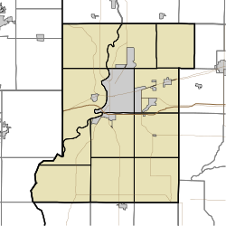
Prairieton is an unincorporated community in Prairieton Township, Vigo County, in the U.S. state of Indiana. [3] Today, due to its proximity to both Terre Haute's southern shopping district (along U.S. Route 41 for approximately two miles south of Interstate 70) and the Terre Haute Federal Penitentiary, it has mostly become a commuter town (State Road 63 provides Prairieton residents access to Terre Haute), with fewer than ten businesses within its "city limits".

Prairieton is part of the Terre Haute Metropolitan Statistical Area.
History

Prairieton was laid out July 22, 1837, by Robert Hoggatt. Situated on Honey Creek, the town also was on the old Vincennes wagon road. Moses Hoggatt had established a post office and store there around 1818, [4] and in its early years the town was known simply as Hoggatt's Store. Hoggatt and then his son Robert Hoggatt were the first shopkeepers. The Quakers were the predominating influence in this prairie in the pioneer days. It became incorporated as a town in 1870 and by 1890 had a population of approximately 236. [5]

A post office was established under the name Hoggatts in 1818. It was renamed to Prairieton in 1840, and is still currently in operation. [6]

Related Research Articles

Vigo County, Indiana County in Indiana

Vigo County is a county on the western border of the U.S. state of Indiana. According to the 2010 United States Census, the population was 107,848. The county seat is Terre Haute.

Terre Haute, Indiana City in Indiana, United States

Terre Haute( TERRHOHT is a city in and the county seat of Vigo County, Indiana, United States, near the state's western border with Illinois. As of the 2010 census, the city had a total population of 60,785 and its metropolitan area had a population of 170,943.

West Terre Haute, Indiana Town in Indiana, United States

West Terre Haute is a town in Sugar Creek Township, Vigo County, Indiana, on the western side of the Wabash River near Terre Haute. The population was 2,236 at the 2010 census. It is part of the Terre Haute Metropolitan Statistical Area. Bethany Congregational Church was placed on the National Register of Historic Places in 2003.

Saint Mary-of-the-Woods, Indiana Unincorporated community in Indiana, United States

Saint Mary-of-the-Woods, often called St. Mary's, is an unincorporated community in Sugar Creek Township in northwestern Vigo County, in the U.S. state of Indiana. The community is part of the Terre Haute Metropolitan Statistical Area. A large portion of Saint Mary-of-the-Woods along U.S. Route 150 is taken up by the grounds of the Sisters of Providence of Saint Mary-of-the-Woods, which contain the motherhouse of the Sisters of Providence as well as Saint Mary-of-the-Woods College. Although Saint Mary-of-the-Woods is unincorporated, it has a post office, with the ZIP code of 47876. It had a population of 797 at the 2010 census.

Libertyville, Indiana Unincorporated community in Indiana, United States

Libertyville is an unincorporated community in Vermillion and Vigo counties, in the U.S. state of Indiana.

Sandford, Indiana Unincorporated community in Indiana, United States

Sandford is an unincorporated community in Fayette Township, Vigo County, in the U.S. state of Indiana.

Burnett, Indiana Unincorporated community in Indiana, United States

Burnett is an unincorporated community in Otter Creek Township, Vigo County, in the U.S. state of Indiana.

Lewis, Indiana Unincorporated community in Indiana, United States

Lewis, also known as Lewisburg or Centerville, is an unincorporated community in Vigo County, in the U.S. state of Indiana. Originally platted entirely within Vigo County, it has now expanded into adjacent Sullivan County.

New Goshen, Indiana Census-designated place in Indiana, United States

New Goshen is a census-designated place (CDP) in Fayette Township, Vigo County, in the U.S. state of Indiana. It is part of the Terre Haute Metropolitan Statistical Area.

Pimento, Indiana Unincorporated community in Indiana, United States

Pimento is an unincorporated community in Linton Township, Vigo County, in the U.S. state of Indiana. It is part of the Terre Haute Metropolitan Statistical Area.

Cloverland, Indiana Unincorporated community in Indiana, United States

Cloverland is an unincorporated community in Posey Township, Clay County, Indiana. It is part of the Terre Haute Metropolitan Statistical Area.

Shepardsville, Indiana Census-designated place in Indiana, United States

Shepardsville is an unincorporated census-designated place in northeastern Fayette Township, Vigo County, in the U.S. state of Indiana. It lies along Trinity Ave. north of the city of Terre Haute, the county seat of Vigo County. Its elevation is 502 feet (153 m), and it is located at 39°36′3″N87°25′3″W. Although Shepardsville is unincorporated, it has a post office, with the ZIP code of 47880.

Prairie Creek, Indiana Unincorporated community in Indiana, United States

Prairie Creek is an unincorporated community in southeastern Prairie Creek Township, Vigo County, in the U.S. state of Indiana. Its elevation is 528 feet (161 m), and it is located at 39°16′30″N87°29′50″W. Because the community has had multiple names, the Board on Geographic Names officially decided in favor of "Prairie Creek" in 1959. Although Prairie Creek is unincorporated, it has a post office, with the ZIP code of 47869.

Fontanet, Indiana Census-designated place in Indiana, United States

Fontanet is an unincorporated census-designated place in central Nevins Township, Vigo County, in the U.S. state of Indiana. It lies along Baldwin St., northeast of the city of Terre Haute, the county seat of Vigo County. Its elevation is 614 feet (187 m), and it is located at 39°34′34″N87°14′37″W. Although Fontanet is unincorporated, it has a post office, with the ZIP Code of 47851.

Vigo, Indiana Unincorporated community in Indiana, United States

Vigo is a small unincorporated community in Prairie Creek Township, Vigo County, in the U.S. state of Indiana. The community is in the 47802 zip code, the Wabash Valley and the Terre Haute Metropolitan Statistical Area.

Toad Hop, Indiana Census-designated place in Indiana, United States

Toad Hop is an unincorporated census-designated place in Sugar Creek Township, Vigo County, in the U.S. state of Indiana. It is officially part of West Terre Haute. In 2010, Toad Hop was a census designated place. It is part of the Terre Haute metropolitan area.

Coal Bluff, Indiana Unincorporated community in Indiana, United States

Coal Bluff is an unincorporated community in northern Nevins Township, Vigo County, in the U.S. state of Indiana.

Tecumseh, Indiana Census-designated place in Indiana, United States

Tecumseh is an unincorporated census-designated place in eastern Fayette Township, Vigo County, in the U.S. state of Indiana. It is part of the Terre Haute metropolitan area.

Youngstown, Indiana Unincorporated community in Indiana, United States

Youngstown is an unincorporated community in southern Honey Creek Township, Vigo County, in the U.S. state of Indiana.

Taylorville, Indiana Unincorporated community in Indiana, United States

Taylorville, also known as Taylorsville or Dresser, is an unincorporated community in eastern Sugar Creek Township, Vigo County, in the U.S. state of Indiana. It is part of the Terre Haute metropolitan area. Though the United States Board on Geographic Names has officially designated the area as Taylorville, the 2010 United States Census considered the area a census designated place called Dresser.

References

  1. "US Board on Geographic Names". United States Geological Survey. 2007-10-25. Retrieved 2008-01-31.
  2. "U.S. Census website". United States Census Bureau . Retrieved 2008-01-31.
  3. "Prairieton, Indiana". Geographic Names Information System . United States Geological Survey . Retrieved August 6, 2017.
  4. Oakey, Charles Cochran (1908). Great Terre Haute and Vigo County. Chicago: Lewis Publishing Co. p. 130.
  5. Bradsby, H.C. (1891). History of Vigo County, Indiana, with Biographical Selections. Chicago: S. B. Nelson & Co. p. 480.
  6. "Vigo County". Jim Forte Postal History. Retrieved July 14, 2016.