Pimento, Indiana | |
---|---|
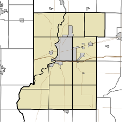
Location in Vigo County, Indiana | |
Coordinates: 39°18′34″N87°22′45″W / 39.30944°N 87.37917°W Coordinates: 39°18′34″N87°22′45″W / 39.30944°N 87.37917°W | |
Country | United States |
State | Indiana |
County | Vigo |
Township | Linton |
Elevation | 600 ft (183 m) |
Time zone | UTC-5 (Eastern (EST)) |
• Summer (DST) | UTC-4 (EDT) |
ZIP code | 47866 [2] |
Area code(s) | 812, 930 |
FIPS code | 18-59868 [3] |
GNIS feature ID | 441145 |
Pimento is an unincorporated community in Linton Township, Vigo County, in the U.S. state of Indiana. [4] It is part of the Terre Haute Metropolitan Statistical Area.
Pimento has one listing on the National Register of Historic Places, the Linton Township High School and Community Building.
Formerly known as Hartford, Pimento was laid out in 1852 by Israel French. The name was changed to Pimento when it became a railroad station on the Evansville & Terre Haute Railroad. Thomas French made the first location in the place and put up a store. The next year came Harvey Weeks, who became a partner in the store. N. B. Bennett began a drug store in 1865, and then a grocery store. A large flour mill was built in 1877, and a tavern, large dry goods store and blacksmith shop soon followed. A town-house was erected in 1858 and the lower part used as a school house. [5]
The post office at Pimento has been in operation since 1855. [6]
Pimento is located at 39°18′34″N87°22′45″W / 39.30944°N 87.37917°W .
Vigo County is a county on the western border of the U.S. state of Indiana. According to the 2020 United States Census, it had a population of 105,994. Its county seat is Terre Haute.
West Terre Haute is a town in Sugar Creek Township, Vigo County, Indiana, on the western side of the Wabash River near Terre Haute. The population was 2,236 at the 2010 census. It is part of the Terre Haute Metropolitan Statistical Area. Bethany Congregational Church was placed on the National Register of Historic Places in 2003.
Libertyville is an unincorporated community in Vermillion and Vigo counties, in the U.S. state of Indiana. The county is in the Terre Haute Metropolitan Statistical Area.
Sandford is an unincorporated community in Fayette Township, Vigo County, in the U.S. state of Indiana. The community is part of the Terre Haute Metropolitan Statistical Area. A small portion of Sandford, now known as West Sandford or “Stringtown”, is in Illinois.
Burnett is an unincorporated community in Otter Creek Township, Vigo County, in the U.S. state of Indiana.
New Goshen is a census-designated place (CDP) in Fayette Township, Vigo County, in the U.S. state of Indiana. It is part of the Terre Haute Metropolitan Statistical Area.
Cloverland is an unincorporated community in Posey Township, Clay County, Indiana. It is part of the Terre Haute Metropolitan Statistical Area.
Turner is an unincorporated community in Posey Township, Clay County, Indiana. It is part of the Terre Haute Metropolitan Statistical Area.
Shepardsville is an unincorporated census-designated place in northeastern Fayette Township, Vigo County, in the U.S. state of Indiana. It lies along Trinity Ave. north of the city of Terre Haute, the county seat of Vigo County. Its elevation is 502 feet (153 m), and it is located at 39°36′3″N87°25′3″W. Although Shepardsville is unincorporated, it has a post office, with the ZIP code of 47880.
Prairie Creek is an unincorporated community in southeastern Prairie Creek Township, Vigo County, in the U.S. state of Indiana. Its elevation is 528 feet (161 m), and it is located at 39°16′30″N87°29′50″W. Because the community has had multiple names, the Board on Geographic Names officially decided in favor of "Prairie Creek" in 1959. Although Prairie Creek is unincorporated, it has a post office, with the ZIP code of 47869.
Fontanet is an unincorporated census-designated place in central Nevins Township, Vigo County, in the U.S. state of Indiana. It lies along Baldwin St., northeast of the city of Terre Haute, the county seat of Vigo County. Its elevation is 614 feet (187 m), and it is located at 39°34′34″N87°14′37″W. Although Fontanet is unincorporated, it has a post office, with the ZIP Code of 47851.
Shirkieville is an unincorporated community in Fayette Township, Vigo County, in the U.S. state of Indiana. The community is part of the Terre Haute Metropolitan Statistical Area. Former state governor and U.S. Senator Evan Bayh was born here.
Vigo is a small unincorporated community in Prairie Creek Township, Vigo County, in the U.S. state of Indiana. The community is in the 47802 zip code, the Wabash Valley and the Terre Haute Metropolitan Statistical Area.
Atherton is an unincorporated community in northern Otter Creek Township, Vigo County, in the U.S. state of Indiana. It is part of the Terre Haute metropolitan area.
Coal Bluff is an unincorporated community in northern Nevins Township, Vigo County, in the U.S. state of Indiana.
Keller is an unincorporated community in Riley Township, Vigo County, in the U.S. state of Indiana. It is part of the Terre Haute metropolitan area. Part of the old general store is still standing, but all other businesses have been torn down. Keller is exclusively a residential community today.
Tecumseh is an unincorporated census-designated place in eastern Fayette Township, Vigo County, in the U.S. state of Indiana. It is part of the Terre Haute metropolitan area.
Youngstown is an unincorporated community in southern Honey Creek Township, Vigo County, in the U.S. state of Indiana.
Taylorville, also known as Taylorsville or Dresser, is an unincorporated community in eastern Sugar Creek Township, Vigo County, in the U.S. state of Indiana. It is part of the Terre Haute metropolitan area. Though the United States Board on Geographic Names has officially designated the area as Taylorville, the 2010 United States Census considered the area a census designated place called Dresser.
Terre Town is an unincorporated community in northern Harrison Township, Vigo County, in the U.S. state of Indiana. Now within the borders of the city of Terre Haute, it is part of the Terre Haute metropolitan area.