State Line, Vigo County, Indiana

Last updated
State Line
Unincorporated community
Map of Indiana highlighting Vigo County.svg
Vigo County's location in Indiana
Map of Vigo County Indiana Townships.svg
Red pog.svg
State Line
location in Vigo County, Indiana
Coordinates: 39°26′13″N87°31′46″W / 39.43694°N 87.52944°W / 39.43694; -87.52944 Coordinates: 39°26′13″N87°31′46″W / 39.43694°N 87.52944°W / 39.43694; -87.52944
Country United States
State Indiana
County Vigo
Township Sugar Creek
Elevation [1] 561 ft (171 m)
Time zone Eastern (EST) (UTC-5)
  Summer (DST) EDT (UTC-4)
ZIP code 47885
Area code(s) 812, 930
GNIS feature ID 444087

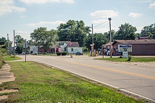
State Line is an unincorporated community in western Sugar Creek Township, Vigo County, in the U.S. state of Indiana. [2]

Unincorporated area Region of land not governed by own local government

In law, an unincorporated area is a region of land that is not governed by a local municipal corporation; similarly an unincorporated community is a settlement that is not governed by its own local municipal corporation, but rather is administered as part of larger administrative divisions, such as a township, parish, borough, county, city, canton, state, province or country. Occasionally, municipalities dissolve or disincorporate, which may happen if they become fiscally insolvent, and services become the responsibility of a higher administration. Widespread unincorporated communities and areas are a distinguishing feature of the United States and Canada. In most other countries of the world, there are either no unincorporated areas at all, or these are very rare; typically remote, outlying, sparsely populated or uninhabited areas.

Sugar Creek Township, Vigo County, Indiana Township in Indiana, United States

Sugar Creek Township is one of twelve townships in Vigo County, Indiana, United States. As of the 2010 census, its population was 7,153 and it contained 3,009 housing units.

Vigo County, Indiana county in Indiana, United States

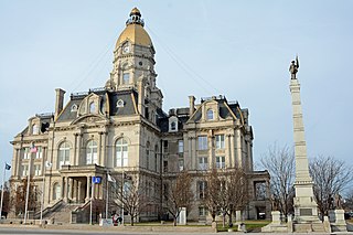
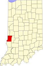
Vigo County is a county located along the western border of the U.S. state of Indiana. According to the 2010 census, the population was 107,848. The county seat is Terre Haute.

Named for its proximity to the state border between Indiana and Illinois, it is part of the Terre Haute metropolitan area.

Illinois State of the United States of America

Illinois is a state in the Midwestern region of the United States. It has the 5th largest Gross Domestic Product by state, is the 6th-most populous U.S. state and 25th-largest state in terms of land area. Illinois is often noted as a microcosm of the entire United States. With Chicago in the northeast, small industrial cities and great agricultural productivity in northern and central Illinois, and natural resources such as coal, timber, and petroleum in the south, Illinois has a diverse economic base, and is a major transportation hub. Chicagoland, Chicago's metropolitan area, contains over 65% of the state's population. The Port of Chicago connects the state to other global ports around the world from the Great Lakes, via the Saint Lawrence Seaway, to the Atlantic Ocean; as well as the Great Lakes to the Mississippi River, via the Illinois Waterway on the Illinois River. The Mississippi River, the Ohio River, and the Wabash River form parts of the boundaries of Illinois. For decades, Chicago's O'Hare International Airport has been ranked as one of the world's busiest airports. Illinois has long had a reputation as a bellwether both in social and cultural terms and, through the 1980s, in politics.

Terre Haute metropolitan area human settlement in United States of America

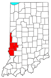
The Terre Haute Metropolitan Statistical Area, also known as the Wabash Valley, is the 227th largest Metropolitan Statistical Area (MSA) in the United States. centering on the city of Terre Haute, it was originally formed by the United States Census Bureau in 1950 and consisted of Vigo County. As surrounding counties saw an increase in their population densities and the number of their residents employed within Vigo County, they met Census criteria to be added to the MSA. Four Indiana counties are now a part of this MSA.

Geography

State Line is located at 39°26′13″N87°31′46″W / 39.43694°N 87.52944°W / 39.43694; -87.52944 at an elevation of 561 feet.

Related Research Articles

Libertyville, Indiana Unincorporated community in Indiana, United States

Libertyville is an unincorporated community in Vermillion and Vigo counties, in the U.S. state of Indiana.

Sandford, Indiana Unincorporated community in Indiana, United States

Sandford is an unincorporated community in Fayette Township, Vigo County, in the U.S. state of Indiana.

Burnett, Indiana Unincorporated community in Indiana, United States

Burnett is an unincorporated community in Otter Creek Township, Vigo County, in the U.S. state of Indiana.

Gasburg, Indiana Unincorporated community in Indiana, United States

Gasburg is an unincorporated community in Monroe Township, Morgan County, in the U.S. state of Indiana.

Prairie Creek, Indiana Unincorporated community in Indiana, United States

Prairie Creek is an unincorporated community in southeastern Prairie Creek Township, Vigo County, in the U.S. state of Indiana. Its elevation is 528 feet (161 m), and it is located at 39°16′30″N87°29′50″W. Because the community has had multiple names, the Board on Geographic Names officially decided in favor of "Prairie Creek" in 1959. Although Prairie Creek is unincorporated, it has a post office, with the ZIP code of 47869.

Vigo, Indiana Unincorporated community in Indiana, United States

Vigo is a small unincorporated community in Prairie Creek Township, Vigo County, in the U.S. state of Indiana. The community is in the 47802 zip code, the Wabash Valley and the Terre Haute Metropolitan Statistical Area.

Blackhawk, Indiana Unincorporated community in Indiana, United States

Blackhawk is an unincorporated community in Pierson Township, Vigo County, in the U.S. state of Indiana. The nearest official town is Riley. Blackhawk has one listing on the National Register of Historical Places in Vigo County, the Frank Senour Round Barn, built in 1905.

Atherton, Indiana Unincorporated community in Indiana, United States

Atherton is an unincorporated community in northern Otter Creek Township, Vigo County, in the U.S. state of Indiana. It is part of the Terre Haute metropolitan area.

Cherryvale, Indiana Unincorporated community in Indiana, United States

Cherryvale is an unincorporated community in Vigo and Clay counties, in the U.S. state of Indiana.

Ehrmandale, Indiana Unincorporated community in Indiana, United States

Ehrmandale is an unincorporated community in southern Nevins Township, Vigo County, in the U.S. state of Indiana.

Hickory Island, Indiana Unincorporated community in Indiana, United States

Hickory Island is an unincorporated community in Vigo and Clay counties, in the U.S. state of Indiana.

Markles, Indiana Unincorporated community in Indiana, United States

Markles is an unincorporated community in southern Otter Creek Township, Vigo County, in the U.S. state of Indiana. Within the boundaries of Terre Haute, it is also part of the Terre Haute metropolitan area.

Pine Ridge, Indiana Unincorporated community in Indiana, United States

Pine Ridge is an unincorporated community in Fayette Township, Vigo County, in the U.S. state of Indiana. It is part of the Terre Haute metropolitan area.

Spring Hill, Vigo County, Indiana Unincorporated community in Indiana, United States

Spring Hill is an unincorporated community in Honey Creek Township, Vigo County, in the U.S. state of Indiana.

Swalls, Indiana Unincorporated community in Indiana, United States

Swalls is an unincorporated community in Lost Creek Township, Vigo County, in the U.S. state of Indiana. It is part of the Terre Haute metropolitan area.

Youngstown, Indiana Unincorporated community in Indiana, United States

Youngstown is an unincorporated community in southern Honey Creek Township, Vigo County, in the U.S. state of Indiana.

Harrison, Indiana Unincorporated community in Indiana, United States

Harrison is an unincorporated community in southeastern Fayette Township, Vigo County, in the U.S. state of Indiana.

Parkview, Indiana Unincorporated community in Indiana, United States

Parkview is an unincorporated community in northern Harrison Township, Vigo County, in the U.S. state of Indiana.

Preston, Indiana Unincorporated community in Indiana, United States

Preston is an unincorporated community in Harrison Township, Vigo County, in the U.S. state of Indiana.

Twelve Points, Indiana Unincorporated community in Indiana, United States

Twelve Points is an unincorporated community in southern Harrison Township, Vigo County, in the U.S. state of Indiana.

References

  1. "US Board on Geographic Names". United States Geological Survey. October 25, 2007. Retrieved 2016-07-14.
  2. "State Line, Vigo County, Indiana". Geographic Names Information System . United States Geological Survey . Retrieved August 7, 2017.