Blackhawk, Indiana | |
|---|---|
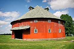 The Frank Senour Round Barn | |
 Vigo County's location in Indiana | |
 Blackhawk | |
| Coordinates: 39°18′32″N87°18′01″W / 39.30889°N 87.30028°W | |
| Country | United States |
| State | Indiana |
| County | Vigo |
| Township | Pierson |
| Elevation | 600 ft (183 m) |
| Time zone | UTC-5 (Eastern (EST)) |
| • Summer (DST) | UTC-4 (EDT) |
| ZIP code | 47866 |
| Area codes | 812, 930 |
| GNIS feature ID | 431150 |
Blackhawk is an unincorporated community in Pierson Township, Vigo County, in the U.S. state of Indiana. [2] The nearest official town is Riley. Blackhawk has one listing on the National Register of Historic Places in Vigo County, the Frank Senour Round Barn, built in 1905.
