
The Hall of Memory is a war memorial in Centenary Square, Birmingham, England, designed by S. N. Cooke and W. N. Twist. Erected 1922–25 by John Barnsley and Son, it commemorates the 12,320 Birmingham citizens who died in World War I.

Stirchley is a suburb in south-west Birmingham, England. The name likely refers to a pasture for cattle. The settlement dates back to at least 1658. Prehistoric evidence, Roman roads, and Anglo-Saxon charters contribute to its history. The Worcester and Birmingham Canal and the railways brought industry to the area. Stirchley's development is also linked to industries like screw-making and rubber manufacturing. Originally part of Worcestershire, Stirchley underwent administrative changes in 1911. Residential developments were established alongside the long-standing Victorian terracing which is associated with the suburb.

Lozells is a loosely defined inner-city area in West Birmingham, England. It is centred on Lozells Road, and is known for its multi-racial population. It is part of the ward of Lozells and East Handsworth and lies between the districts of Handsworth and Aston.

Lifford Reservoir in the Kings Norton district of Birmingham, England was built by the Worcester & Birmingham Canal company in 1815 to compensate Lifford Mill for water lost to the canal. It is located at the junction of the Stratford-upon-Avon Canal and the Worcester and Birmingham Canal and is on the River Rea Cycle Route. Angling is permitted subject to a charge outside the spring close season. Fish in the reservoir include tench, carp, pike, eels, perch, roach and bream.

The A5127 is a major road in England which runs between Birmingham and Lichfield, Staffordshire. For much of the route the road follows the old route of the A38 which has since been moved in order to by-pass places such as Erdington and Sutton Coldfield and form a relief road from Birmingham city centre to Spaghetti Junction.

The Great Western Arcade is a covered Grade II listed Victorian shopping arcade lying between Colmore Row and Temple Row in Birmingham City Centre, England.
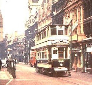
Birmingham Corporation Tramways operated a network of tramways in Birmingham from 1904 until 1953. It was the largest narrow-gauge tramway network in the UK, and was built to a gauge of 3 ft 6 in. It was the fourth largest tramway network in the UK behind London, Glasgow and Manchester.

St. Barnabas' Church is a Church of England parish church in Erdington in the north of Birmingham, England.
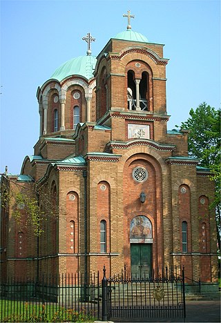
The Serbian Orthodox Church of the Holy Prince Lazar, also known as Lazarica (Лазарица), is a Serbian Orthodox church located at Cob Lane in Bournville, Birmingham, England and was built for political refugees from Yugoslavia after World War II, with the support of the exiled Prince Tomislav of Yugoslavia. Serbs have been associated with Bournville since Dame Elizabeth Cadbury sponsored thirteen Serbian refugee children of World War I.
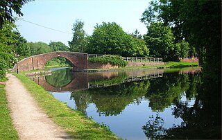
Kings Norton Junction is the name of the canal junction where the Stratford-upon-Avon Canal terminates and meets the Worcester and Birmingham Canal at Kings Norton, Birmingham, England.

Kings Norton Stop Lock is a Grade II* listed building at Kings Norton Junction on the Stratford-upon-Avon Canal near its junction with the Worcester and Birmingham Canal. It is the only guillotine-gated stop-lock on a canal.

Kingswood Junction is a canal junction where the Stratford-upon-Avon Canal meets the Grand Union Canal at Kingswood, Warwickshire, England.
Belle Meade is an upscale neighborhood in Memphis, Tennessee. Belle Meade is bordered by Goodlett Street in the west, Walnut Grove Road at the north, Poplar Avenue at the south, and roughly East Cherry Circle on the east.
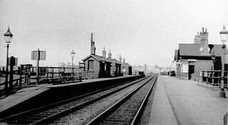
Lifford railway station refers to a series of railway stations in Cotteridge, Birmingham, England.
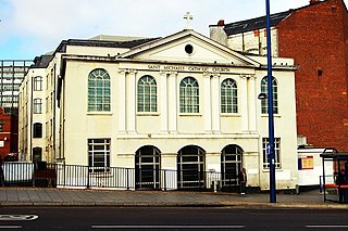
St Michael's Catholic Church is a Catholic church located on Moor Street in Birmingham, England. It received Grade II listed building status on 25 April 1952.

The Crescent was a part-completed Regency-style terrace in central Birmingham, England. The scheme was first proposed in 1788, construction started in 1795 and was discontinued the same year. The partially-completed terrace was finally demolished in the mid- to late 1960s. Like other late 18th and early 19th century crescent terraces in Britain and Ireland, it took its inspiration from The Crescent, Bath, designed by John Wood the Younger and built 1767 to 1774.

The Chamberlain Clock is an Edwardian, cast-iron, clock tower in the Jewellery Quarter of Birmingham, England. It was erected in 1903 to mark Joseph Chamberlain's tour of South Africa between 26 December 1902 and 25 February 1903, after the end of the Second Boer War. The clock was unveiled during Chamberlain's lifetime, in January 1904 by Mary Crowninshield Endicott, Joseph Chamberlain's third wife.

The Friends Institute Buildings are a former Religious Society of Friends (Quaker) meeting house, community facilities, and associated structures, at 220, Moseley Road, Balsall Heath, Birmingham, England. The various parts are now used as an Art therapy centre, and the Moseley Road Community Centre. In September 2014, the buildings were granted Grade II* designation.
St James’s House is a Grade II listed office building in Birmingham, England.
Selly Park Girls' School is a secondary school located in the Selly Park area of Birmingham, in the West Midlands of England.
