
This article provides a breakdown of the transportation options available in Cameroon. These options are available to citizens and tourists such as railways, roadways, waterways, pipelines, and airlines. These avenues of transport are used by citizens for personal transportation, of goods, and by tourists for both accessing the country and traveling.
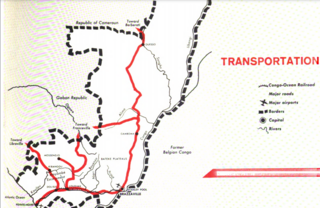
Transport in the Republic of Congo includes land, air and water modes. Over 3,000 km (1,900 mi) of paved roads are in use. The two international airports are Maya-Maya Airport and Pointe Noire Airport.
The M1 motorway is a motorway in Ireland. It forms the large majority of the N1 national primary road connecting Dublin towards Belfast along the east of the island of Ireland. The route heads north via Swords, Drogheda and Dundalk to the Northern Irish border just south of Newry in County Armagh, where it joins the A1 road and further on, the M1 motorway in Northern Ireland. It also forms a significant part of the road connection between Dublin and the Northern Irish cities of Newry, and Lisburn. The route is part of European route E01.

The N1 is a national route in South Africa that runs from Cape Town through Bloemfontein, Johannesburg, Pretoria and Polokwane to Beit Bridge on the border with Zimbabwe. It forms the first section of the famed Cape to Cairo Road.

The Walvis Bay-Ndola-Lubumbashi Development Road runs from Walvis Bay, through Rundu in north eastern Namibia, along the Caprivi Strip to Katima Mulilo on the Zambezi River, which forms the border between Namibia and Zambia. The Katima Mulilo Bridge spans the river to the Zambian town of Sesheke from where a road runs to Livingstone, joining the main north–south highway to Lusaka, connecting onwards to the Copperbelt.

The N12 is a national route in South Africa which runs from George through Beaufort West, Kimberley, Klerksdorp and Johannesburg to eMalahleni.
National road or National route may refer to:
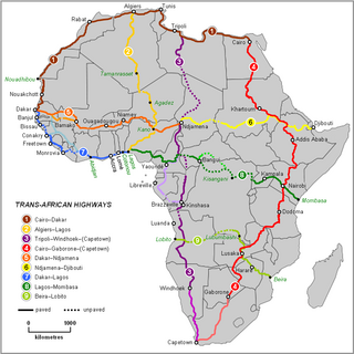
The Trans-African Highway network comprises transcontinental road projects in Africa being developed by the United Nations Economic Commission for Africa (UNECA), the African Development Bank (ADB), and the African Union in conjunction with regional international communities. They aim to promote trade and alleviate poverty in Africa through highway infrastructure development and the management of road-based trade corridors. The total length of the nine highways in the network is 56,683 km (35,221 mi).
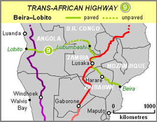
The Beira–Lobito Highway or TAH 9 is Trans-African Highway 9 in the transcontinental road network being developed by the United Nations Economic Commission for Africa (UNECA), the African Development Bank (ADB), and the African Union. The route has a length of 3,523 km (2,189 mi) crossing Angola, the most southerly part of the Democratic Republic of the Congo, Zambia, Zimbabwe, and central Mozambique.
The Tripoli–Cape Town Highway or TAH 3 is Trans-African Highway 3 in the transcontinental road network being developed by the United Nations Economic Commission for Africa (UNECA), the African Development Bank (AfDB), and the African Union. The route has a length of 10,808 km (6,716 mi) and has the longest missing links and requires the most new road construction.

U.S. Route 160 (US 160), also known as the Navajo Trail, is a U.S. Highway which travels west to east across the Navajo Nation and Northeast Arizona for 159.35 miles (256.45 km). US 160 begins at a junction with US 89 north of Cameron and exits the state into New Mexico south of the Four Corners Monument. Along its journey, the route connects the communities of Tuba City, Moenkopi, Rare Metals, Tonalea, Tsegi, Kayenta, Dennehotso, Mexican Water, Red Mesa, and Teec Nos Pos.

The Cairo–Cape Town Highway is Trans-African Highway 4 in the transcontinental road network being developed by the United Nations Economic Commission for Africa (UNECA), the African Development Bank (AfDB), and the African Union. The route has a length of 10,228 km (6,355 mi) and links Cairo in Egypt to Cape Town in South Africa.
This page is based on this
Wikipedia article Text is available under the
CC BY-SA 4.0 license; additional terms may apply.
Images, videos and audio are available under their respective licenses.