Related Research Articles
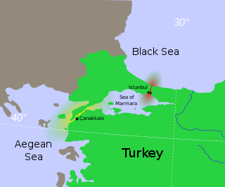
The Sea of Marmara, also known as the Sea of Marmora or the Marmara Sea, is a small inland sea located entirely within the borders of Turkey. It connects the Black Sea to the Aegean Sea via the Bosporus and Dardanelles straits, separating Turkey’s European and Asian sides. It has an area of 11,350 km2 (4,380 sq mi), and its dimensions are 280 km × 80 km. Its greatest depth is 1,370 m (4,490 ft).

The Sultanate of Rum was a culturally Turco-Persian Sunni Muslim state, established over conquered Byzantine territories and peoples (Rum) of Anatolia by the Seljuk Turks following their entry into Anatolia after the Battle of Manzikert in 1071. The name Rum was a synonym for the medieval Eastern Roman Empire and its peoples, as it remains in modern Turkish. The name is derived from the Aramaic and Parthian names for ancient Rome, via the Greek Ῥωμαῖοι.
Cape Jason (Turkish: Yason Burnu; is a cape located at Çaytepe / Çaka villages, Perşembe district, Ordu Province, Turkey. Its name is derived from the Greek mythological hero Jason of the Argonauts.
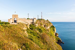
Kaliakra is a cape in the Southern Dobruja region of the northern Bulgarian Black Sea Coast, which ends with a long and narrow headland 12 kilometres (7 mi) east of Kavarna, 60 kilometres (37 mi) northeast of Varna and 65 kilometres (40 mi) southwest of Mangalia. The coast is steep with vertical cliffs reaching 70 metres (230 ft) down to the sea. Kaliakra is a nature reserve, where dolphins and cormorants can be observed. It sits on the Via Pontica, a major bird migration route from Africa into Eastern and Northern Europe. Many rare and migrant birds can be seen here in spring and autumn and, like much of this coastline, is home to several rare breeding birds. The rest of the reserve also has unusual breeding birds; saker falcon, lesser grey shrike and a host of others.

The Seljuk dynasty, or Seljukids, Seljuqs, also known as Seljuk Turks, Seljuk Turkomans or the Saljuqids, was an Oghuz Turkic, Sunni Muslim dynasty that gradually became Persianate and contributed to Turco-Persian culture in West Asia and Central Asia. The Seljuks established the Seljuk Empire (1037–1194), the Sultanate of Kermân (1041–1186) and the Sultanate of Rum (1074–1308), which stretched from Iran to Anatolia and were the prime targets of the First Crusade.
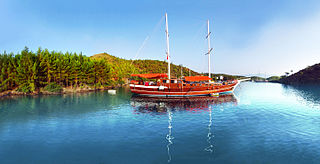
A Blue Cruise, also known as a Blue Voyage or Blue Tour, is a term used for recreational voyages along the Turkish Riviera, on Turkey's southwestern coast along the Aegean and Mediterranean seas. The cruise is typically a week-long trip aboard the local gulet schooners, to ancient cities, harbors, tombs, and beaches in the numerous small coves along the country's Turquoise Coast.
Mehmet Ufuk Uras is a Turkish politician and economist.
D.400 is an east–west state road in southern Turkey. The 2,057-kilometre (1,278 mi) road starts at Datça in the southwest corner of the Anatolian peninsula and ends at the Iranian border at Esendere.
Özhan Öztürk is a Turkish writer and researcher. He wrote a Turkish Folklore Encyclopaedia and an encyclopaedic dictionary of the culture and folklore of the peoples of the Black Sea region of Turkey.
Turkey straddles two peninsulas: Anatolia in Asia and Thrace in Europe. The surrounding seas are the Black Sea, Sea of Marmara, Aegean Sea and Mediterranean Sea. But the number of gulfs in the north and the south (Mediterranean) is not high, because the mountain ranges lie more or less parallel to the coastline both in the north and in the south. The majority of bays are on the west, where the mountain ranges are perpendicular to the coastline.
Gulf of Mersin is one of the widest gulfs in Turkey. It is in the northeast of the Mediterranean Sea between the gulfs of İskenderun and Antalya.

Morto Bay is an inlet on the South West tip of Cape Helles on the Gallipoli Peninsula in Turkey. The bay is in the north west (European) coast of the Dardanelles strait, which connects the Sea of Marmara to Aegean Sea. The Gallipoli Peninsula is to the north of the bay. Administratively it is a part of Çanakkale Province. The width of the bay is about 2.6 kilometres (1.6 mi) The name of the bay is probably of Italian origin.
Kemankeş Kara Mustafa Pasha was an Ottoman Albanian military officer and statesman who served as Kapudan Pasha and Grand Vizier of the Ottoman Empire.

D.850 is a north-to-south state road in Turkey. It starts at Ünye at the Black Sea coast and ends at Öncüpınar, which hosts a Turkish border check point with Syria. Since it runs all the way from north to south, it crosses the three main west-to-east highways, namely the D.100, D.300 and D.400.

The Armutlu Peninsula is a peninsula extending westward into Marmara Sea in the Anatolian section of Turkey. In addition to Yalova Province, parts of Kocaeli Province and Bursa Province are on the peninsula.

Ottoman wars in Asia refers to the wars involving the Ottoman Empire in Asia. Ottoman Empire was founded at the beginning of the 14th century. Its original settlement was in the northwest Anatolia where it was a small beylik (principality). Its main rival was Byzantine Empire. In 1350s Ottomans were able to cross the Dardanelles strait and eventually they conquered most of the Balkans. Although they mainly concentrated their expansions in Europe, they also expanded their territories in Asia, mainly in Fertile Crescent and Arabian Peninsula.
Karaburun is a district and the center town of the same district of İzmir Province, Turkey.

Kireçburnu is a neighbourhood in the municipality and district of Sarıyer, Istanbul Province, Turkey. Its population is 6,888 (2022). It is located on the northern shore of Bosphorus at European side. It is to the north of İstanbul centre with a distance over 15 kilometres (9.3 mi).
Cape Agrilia, anciently Malea or Malia (Μαλία) or Mania (Μανία), Latin: Malia Promontorium, is the southeasternmost point of the island of Lesbos. It is also known as Agrelias.
References
- ↑ Faik Sabri Duran, Büyük Atlas (İstanbul: Kanaat Yayınevi, 2001; ISBN 975-7537-04-7).
- ↑ Türkiye Turizm Atlası 2009 İstanbul:Boyut Yayıncılık, 2009`; ISBN 978-975-23-0634-9
- ↑ The capes on Lake Van are not shown
- ↑ Westernmost point of Asia
| Black Sea |
|
|---|---|
| Marmara | |
| Aegean | |
| Mediterranean | |
| Related geographical features | |