The following is a list of dams and reservoirs in Iraq. They are sorted according to their location in either the Euphrates or the Tigris river basin.
The Euphrates is the longest and one of the most historically important rivers of Western Asia. Together with the Tigris, it is one of the two defining rivers of Mesopotamia. Originating in Turkey, the Euphrates flows through Syria and Iraq to join the Tigris in the Shatt al-Arab, which empties into the Persian Gulf.
The geography of Iraq is diverse and falls into five main regions: the desert, Upper Mesopotamia, the northern highlands of Iraq, Lower Mesopotamia, and the alluvial plain extending from around Tikrit to the Persian Gulf.
The Tigris is the easternmost of the two great rivers that define Mesopotamia, the other being the Euphrates. The river flows south from the mountains of the Armenian Highlands through the Syrian and Arabian Deserts, and empties into the Persian Gulf.
The Tigris–Euphrates river system is a large river system in Western Asia which discharges into the Persian Gulf. Its principal rivers are the Tigris and Euphrates along with smaller tributaries.
The Diyala River is a river and tributary of the Tigris. It is formed by the confluence of Sirwan river and Tanjaro river in Darbandikhan Dam in the Sulaymaniyah Governorate of Northern Iraq. It covers a total distance of 445 km (277 mi).
Arshad Pasha al-Umari was an Iraqi statesman from the ancient al-Omari family.
The Little Zab or Lower Zab is a river that originates in Iran and joins the Tigris just south of Al Zab in the Kurdistan region of Iraq. It is approximately 400 kilometres (250 mi) long and drains an area of about 22,000 square kilometres (8,500 sq mi). The river is fed by rainfall and snowmelt, resulting in a peak discharge in spring and low water in summer and early fall. Two dams have been built on the Little Zab, regulating the river flow, providing water for irrigation and generating hydroelectricity. The Zagros Mountains have been occupied since at least the Lower Palaeolithic, but the earliest archaeological site in the Little Zab basin, Barda Balka, dates to the Middle Palaeolithic. Human occupation of the Little Zab basin has been attested for every period since then.
The Gharraf Canal, Shaṭṭ al-Ḥayy, also known as Shaṭṭ al-Gharrāf or the Hai river, is an ancient canal in Iraq that connects the Tigris at Kut al Amara with the Euphrates east of Nasiriyah. As an Ottoman (Turkish) position lay along the canal, it was one of the objectives of intense military action during the First World War, especially the siege of Kut.
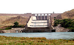
The Samarra Barrage is a multi-purpose barrage on the Tigris River adjacent (west) of Samarra and north of Baghdad, Iraq. The main purpose of the dam is to divert floodwater in the Tigris River to Lake Tharthar through the Tharthar depression along with irrigation and an 84 MW hydro-electricity station. It also serves to produce hydroelectric power and flood control – although the later has become less critical with the construction of the Mosul Dam upstream and several other large dams in Turkey.
Ramadi Barrage is a two-section diversion dam on the Euphrates River adjacent (west) of Ramadi, Iraq. The main purpose of the northern barrage is to slow or stop water if needed, allowing it to be diverted through the southern barrage into a canal. The canal feeds water into Lake Habbaniyah to the southeast.
The Dibis (Dibbis) Dam or Dibis Regulator is a gravel-alluvial fill embankment dam located on Lesser Zab River approximately 130 km upstream from its confluence with the Tigris River. The dam is located directly north of the town of Dibis in Kirkuk Governorate, Iraq. The main-purpose of the Dibis Dam is to divert water from the Lesser Zab River into the Kirkuk Irrigation Project.
The Sirwan River, is a river and tributary of the Tigris that originates in Iran as the Sirwan River then runs mainly through Eastern Iraq. It covers a total distance of 445 km (277 mi).
The Hindiya Barrage is a barrage on the Euphrates south of the town of Musayyib in Babil Governorate of Iraq. Located north of the Al-Hindiya District, it was designed by British civil engineer William Willcocks in response to the silting up of the Hillah branch of the Euphrates. Construction of the dam, with a length of over 250 metres (820 ft), lasted between 1911 and 1913. Between 1984 and 1989, a new dam was built several kilometres upstream as a replacement for the Hindiya Barrage.
Al-Hindiya District is a district of the Karbala Governorate, Iraq. Its largest town is Al-Hindiya, to the east of Karbala. The Hindiya Barrage in the north of the district controls floods and diverts water from the Euphrates into irrigation canals on both sides of the river. The district has been the scene of clashes with Turkish and British colonial forces, and more recently with American troops in 2003. The population is about 230,000, mostly Shia, including significant numbers of refugees. Infrastructure is poor, but efforts are being made to improve it.
The 2002–03 Iraq FA Cup was the 25th edition of the Iraq FA Cup as a clubs-only competition, the main domestic cup in Iraqi football. It kicked off on 2 September 2002, and the final was played on 23 August 2003 at the Franso Hariri Stadium in Erbil rather than at Al-Shaab Stadium in Baghdad due to security reasons.
The 2020–21 Iraq FA Cup was the 31st edition of the Iraqi knockout football cup as a clubs-only competition, the main domestic cup in Iraqi football, featuring 126 teams. It started on 20 October 2020 and the final was played on 19 July 2021 at Al-Shaab Stadium in Baghdad.
The 2021–22 Iraq FA Cup was the 32nd edition of the Iraqi knockout football cup as a clubs-only competition, the main domestic cup in Iraqi football, featuring a record 168 clubs from the top four tiers of the Iraqi football league system,. The competition began on 10 September 2021 with the first-round matches involving teams from the third and fourth tiers, and the final was played on 16 July 2022 at Al-Madina Stadium in Baghdad.
Alwand Dam is a dam located on the Alwand River, southeast of Khanaqin, 6 km (3.7 mi) from the Iraqi-Iranian border. It is a hydroponic dam with a mud core with a length of 1,342 m (4,403 ft) and a height of 24 m (79 ft). The storage quantities in the dam’s lake is 38,000,000 m3 (1.3×10⁹ cu ft) and the surface area of the lake is 6,200,000 m2 (67,000,000 sq ft).