
The Mahaweli River, is a 335 km (208 mi) long river, ranking as the longest river in Sri Lanka. It has a drainage basin of 10,448 km2 (4,034 sq mi), the largest in the country, which covers almost one-fifth of the total area of the island. The Mahaweli Ganga starts at Polwathura, a remote village of Nuwara-Eliya District in bank Nawalapitiya of Kandy District by further joining of Hatton Oya and Kotmale Oya. The river reaches the Bay of Bengal on the southwestern side of Trincomalee Bay. The bay includes the first of a number of submarine canyons, making Trincomalee one of the finest natural deep-sea harbours in the world.

The Kotmale River is the longest tributary of Mahaweli River. The river begins as the Agra Oya, in the Horton Plains. The Central Plains have an annual rainfall of between 125 and 200 inches a year. The river is approximately 70 km (43 mi) long and drains a basin of about 58,534 ha. The river flows through a traditional area of ancient villages and tea plantations. King Dutugemunu spent his youth here. The Kotmale Oya flows into the Mahaweli at Pallegama. Tributaries of the Kotmale Oya include the Nanu Oya, the Pundalu Oya, the Puna Oya, and the Dambagastalawa Oya.

St. Clair's Falls is one of the widest waterfalls in Sri Lanka and is commonly known as the "Little Niagara of Sri Lanka". It is one of six waterfalls affected by the Upper Kotmale Hydropower Project.

Victoria Dam is an arch dam located 130 mi (209 km) upstream of the Mahaweli River's mouth and 4 mi (6 km) from Teldeniya. It is named in honour of Queen Victoria of the United Kingdom.

The Samanala Dam is a dam primarily used for hydroelectric power generation in Sri Lanka. Commissioned in 1992, the Samanalawewa Project is the third-largest hydroelectric scheme in the country, producing 405 GWh of energy annually. It was built with financial support from Japan and the United Kingdom. It is notable for a large leak on its right bank. Power production continues as planned despite the leakage, and the water from the leak now provides two thirds of the water issued by the reservoir for agriculture in downstream areas.

The electricity sector in Sri Lanka has a national grid which is primarily powered by hydroelectric power and thermal power, with sources such as photovoltaics and wind power in early stages of deployment. Although potential sites are being identified, other power sources such as geothermal, nuclear, solar thermal and wave power are not used in the power generation process for the national grid.

The Upper Kotmale Dam is located in Talawakele, within the Nuwara Eliya District, in the Central Province of Sri Lanka. The dam feeds the third largest hydroelectric power station in the country.

The Ubol Ratana Dam, formerly known as the "Phong Neeb Dam", is a multi-purpose dam in tambon Khok Sung, Ubolratana district, approximately 50 km (31 mi) north of Khon Kaen, Khon Kaen province, Thailand. It was the first hydroelectric power project developed in Thailand's northeastern area of Isan. The dam impounds the Nam Phong, which flows into the Chi River and thence to the Mun River, a tributary of the Mekong River. The dam was given its current name by royal permission in 1966, in honour of princess Ubol Ratana, the eldest child of King Bhumibol Adulyadej.

The Broadlands Dam is a 35 MW run-of-the-river hydroelectric complex currently under construction in Kitulgala, Sri Lanka. The project is expected to be completed in 2020, and will consist of two dams, and a power station downstream.

The Moragahakanda Dam, officially Kulasinghe Reservoir, is a large gravity dam, and the main component of the larger and more complex Moragahakanda — Kalu Ganga Project, across the Amban River at Elahera, in the Matale District of Sri Lanka. Construction began on 25 January 2007 and was completed in 2018. The maiden water release of the dam was in January 2017. Morgahakanda/Kaluganga project is the last of the Great Mahaveli project

The Kalu Ganga Dam is a large gravity dam, and the second vital component of the larger and more complex Moragahakanda — Kalu Ganga Project across the Kalu Ganga at Pallegama, in the Matale District of Sri Lanka. The Kalu Ganga is a tributary of the Amban Ganga which in turn is a tributary of the Mahaweli River, the longest river in Sri Lanka. Construction of the project was launched by President Mahinda Rajapaksa on 25 January 2007. The maiden waters of the dam was released in July 2018.

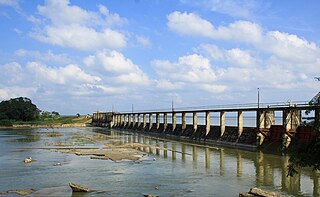
The Polgolla Barrage is a barrage built across the Mahaweli River at Polgolla, in the Central Province of Sri Lanka. The main purpose of the barrage is to maintain the water level of Mahaweli river at a constant height to provide a uniform potential head at the intake to the underground tunnel which conveys water to Ukuwela powerplant.

The Kehelgamu Oya is a major upstream tributary of the Kelani River. The tributary measures 50 km (31 mi) in length, originating in the hills of the Horton Plains National Park, before passing through the Castlereigh Reservoir. Kehelgamu Oya converges with the Maskeliya Oya at Kalugala, forming the 100 km (62 mi) long Kelani River. The river is heavily used for hydroelectric power generation.

The Gal Oya Dam is an embankment dam in the Uva Province of Sri Lanka. The dam creates one of the largest reservoirs in the country, the Gal Oya Reservoir. Water from the reservoir is used primarily for irrigation in the Uva and Eastern provinces, in addition to powering a small hydroelectric power station. Construction of the dam and reservoir began in August 24, 1949, completing four years later in 1953.

The Vorotan Cascade, or the ContourGlobal Hydro Cascade, is a cascade on the Vorotan River in Syunik Province, Armenia. It was built to produce hydroelectric power and provide irrigation water. The Vorotan Cascade consists of three hydroelectric power plants and five reservoirs with a combined installed capacity of 404.2 MW. It is one of the main power generation complexes in Armenia.
Iranamadu Tank is an irrigation tank in northern Sri Lanka, approximately 3 mi (5 km) south east of Kilinochchi.
The Mahaweli Development program is known as the largest multipurpose national development program in the history of Sri Lanka and is also considered the keystone of the government's development program that was initiated in 1961.
The Uma Oya Hydropower Complex (also internally called Uma Oya Multipurpose Development Project or UOMDP) is an irrigation and hydroelectric complex in the Badulla District of Sri Lanka. Early assessments of the project date back to 1989, when the first studies was conducted by the country's Central Engineering and Consultancy Bureau. The complex involves building a dam across Dalgolla Oya, and channelling water over a 3,975 m (13,041 ft) tunnel to Mathatilla Oya, both of which are tributaries of the Uma Oya. At Mathatilla Oya, another dam is constructed to channel 145,000,000 m3 (5.1×10⁹ cu ft) of water per annum, via a 15,290 m (50,160 ft) headrace tunnel to the Uma Oya Power Station, where water then discharged to the Alikota Aru via a 3,335 m (10,942 ft) tailrace tunnel.
The Moragolla Dam is a planned hydroelectric dam in Moragolla, Sri Lanka. The dam is to be 35 m (115 ft) high and is planned to create the 1,980,000 m3 (70,000,000 cu ft) Moragolla Reservoir with a maximum supply level at 548 m (1,798 ft) MSL. Upon completion, the Moragolla Power Station would have a gross installed capacity of 30 megawatts from two francis turbines, capable of generating approximately 85 GWh annually.


