
ISO 6709, Standard representation of geographic point location by coordinates, is the international standard for representation of latitude, longitude and altitude for geographic point locations.
Vanni Electoral District is one of the 22 multi-member electoral districts of Sri Lanka created by the 1978 Constitution of Sri Lanka. The district covers the administrative districts of Mannar, Mullaitivu and Vavuniya in the Northern province. The district currently elects 6 of the 225 members of the Sri Lankan Parliament and had 253,058 registered electors in 2014.
The Kent and Dollar Farm massacres were the first massacres of Sinhalese civilians carried out by the LTTE during the Sri Lankan Civil War. The massacres took place on 30 November 1984, in two tiny farming villages in the Mullaitivu district in north-eastern Sri Lanka. The Sri Lankan government labeled this as an attack on civilians by the LTTE.
The Vanni, also spelled Wanni, is the name given to the mainland area of the Northern Province of Sri Lanka. It covers the entirety of Mannar, Mullaitivu and Vavuniya Districts, and most of Kilinochchi District. It has an area of approximately 7,650 square kilometres (2,950 sq mi). The population and infrastructure of the Vanni were devastated by the Sri Lankan Civil War.
Mullaitivu District is one of the 25 districts of Sri Lanka, the second level administrative division of the country. The district is administered by a District Secretariat headed by a District Secretary appointed by the central government of Sri Lanka. The capital of the district is the town of Mullaitivu.

Vavuniya District is one of the 25 districts of Sri Lanka, the second level administrative division of the country. The district is administered by a District Secretariat headed by a District Secretary appointed by the central government of Sri Lanka. The capital of the district is the city of Vavuniya.

The North and East Operations Medal was a decoration presented to servicepersons of the Military of Sri Lanka and Sri Lanka Police for service in the country's Northern and Eastern provinces during the course of the Sri Lankan Civil War between 23 July 1982 and 1 January 2010.

The Purna Bhumi Padakkama was a service medal awarded by the Military of Sri Lanka and Sri Lanka Police to all ranks of its forces in recognition of service in various districts that were regarded as theaters of the Sri Lankan Civil War between 22 July 1977 to 1 January 2010.
Security Forces Headquarters – Wanni is a regional command of the Sri Lanka Army, that is responsible for the operational deployment and command all army units stationed in and around the southern part or the Vanni region of the Northern Province, this includes several divisions and the independent brigades. Currently due to ongoing combat operations it is the largest command in the country. It is one of the five Security Forces Headquarters and the General Officer Commanding it is one of the most senior officers in the army, the post is designated as Commander Security Forces Headquarters - Vanni. The current Commander SFHQ-W is Major General Hemantha Bandara. The SFHQ-W is based at the defense complex at Vavuniya.
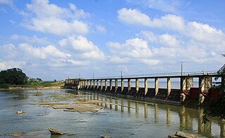
The Kanakarayan Aru is a river in Northern Province, Sri Lanka. The river rises in eastern Vavuniya District, near Omanthai, and flows north through Vavuniya District, Mullaitivu District and Kilinochchi District. It empties into the Chundikkulam Lagoon.
The Pali Aru is a river in Northern Province, Sri Lanka. The river rises in northern Vavuniya District, near Puliyankulam, flowing north/northwest through Vavuniya District, Mullaitivu District and Mannar District. The river empties into Palk Bay. The southern section of the river is sometimes known as the Chamalankulam Aru.
The Nay Aru is a river in Northern Province, Sri Lanka. The river rises in south-west Vavuniya District, before flowing north/north-west through Vavuniya District and Mannar District. The river empties into Palk Bay.
The Per Aru is a river in Northern Province, Sri Lanka. The river rises in northern Vavuniya District, before flowing north/north-east through Vavuniya District and Mullaitivu District. The river empties into Nanthi Kadal lagoon.
Nay Aru is the name of two rivers in Northern Province, Sri Lanka:

The Northern Province is one of the nine provinces of Sri Lanka. The province has an area of 8,884 km2, making it the 3rd largest province by area, and a population of 1,061,315, making it the least populated province. The city of Jaffna is the capital city of the province.

Mannar District is one of the 25 districts of Sri Lanka, the second level administrative division of the country. The district is administered by a District Secretariat headed by a District Secretary appointed by the central government of Sri Lanka. The capital of the district is Mannar, which is located on Mannar Island.
Weli Oya,(Sinhala: වැලිඔය, romanized: Weli Oya) is a Sinhalese colony area in Mullaithivu District, Sri Lanka formerly known as Manal Aru. Weli Oya has been affected by the Sri Lankan civil war and government Sinhala colonization programs.
Sun British College is a private college in Vavuniya, Sri Lanka. It is recognized by the Association of Accounting Technicians of Sri Lanka.


