Chalai Lagoon

Last updated
Chalai Lagoon
Location Mullaitivu District, Sri Lanka
Coordinates 9°23′N80°40′E / 9.383°N 80.667°E / 9.383; 80.667 Coordinates: 9°23′N80°40′E / 9.383°N 80.667°E / 9.383; 80.667
Type Lagoon
Primary outflows Indian Ocean
Surface area14.6 square kilometres (5.6 sq mi)
Surface elevation Sea level
SettlementsChalai
Putumattalan
Valayanmadam

Chalai Lagoon is a lagoon in Mullaitivu District, north-east Sri Lanka. The town of Chalai is located on a sand bar between the lagoon and the Indian Ocean.

Lagoon A shallow body of water separated from a larger body of water by barrier islands or reefs

A lagoon is a shallow body of water separated from a larger body of water by barrier islands or reefs. Lagoons are commonly divided into coastal lagoons and atoll lagoons. They have also been identified as occurring on mixed-sand and gravel coastlines. There is an overlap between bodies of water classified as coastal lagoons and bodies of water classified as estuaries. Lagoons are common coastal features around many parts of the world.

Mullaitivu District Administrative District in Northern, Sri Lanka

Mullaitivu District is one of the 25 districts of Sri Lanka, the second level administrative division of the country. The district is administered by a District Secretariat headed by a District Secretary appointed by the central government of Sri Lanka. The capital of the district is the town of Mullaitivu.

Sri Lanka Island country in South Asia

Sri Lanka, officially the Democratic Socialist Republic of Sri Lanka, is an island country in South Asia, located in the Indian Ocean to the southwest of the Bay of Bengal and to the southeast of the Arabian Sea. The island is geographically separated from the Indian subcontinent by the Gulf of Mannar and the Palk Strait. The legislative capital, Sri Jayawardenepura Kotte, is a suburb of the commercial capital and largest city, Colombo.

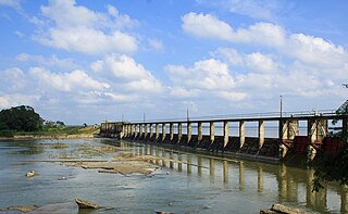
The lagoon is fed by a number of small rivers. It is linked to the sea by a narrow channel near Chalai. The lagoon's water is brackish.

River Natural flowing watercourse

A river is a natural flowing watercourse, usually freshwater, flowing towards an ocean, sea, lake or another river. In some cases a river flows into the ground and becomes dry at the end of its course without reaching another body of water. Small rivers can be referred to using names such as stream, creek, brook, rivulet, and rill. There are no official definitions for the generic term river as applied to geographic features, although in some countries or communities a stream is defined by its size. Many names for small rivers are specific to geographic location; examples are "run" in some parts of the United States, "burn" in Scotland and northeast England, and "beck" in northern England. Sometimes a river is defined as being larger than a creek, but not always: the language is vague.

Channel (geography) A type of landform in which part of a body of water is confined to a relatively narrow but long region

In physical geography, a channel is a type of landform consisting of the outline of a path of relatively shallow and narrow body of fluid, most commonly the confine of a river, river delta or strait. The word is cognate to canal, and sometimes takes this form, e.g. the Hood Canal.

The lagoon is surrounded by dense forest, scrubland and some rice paddies. The land is used for fishing and some salt production.

Forest dense collection of trees covering a relatively large area

A forest is a large area dominated by trees. Hundreds of more precise definitions of forest are used throughout the world, incorporating factors such as tree density, tree height, land use, legal standing and ecological function. According to the widely used Food and Agriculture Organization definition, forests covered 4 billion hectares (9.9×10⁹ acres) (15 million square miles) or approximately 30 percent of the world's land area in 2006.

Fishing Activity of trying to catch fish

Fishing is the activity of trying to catch fish. Fish are normally caught in the wild. Techniques for catching fish include hand gathering, spearing, netting, angling and trapping. “Fishing” may include catching aquatic animals other than fish, such as molluscs, cephalopods, crustaceans, and echinoderms. The term is not normally applied to catching farmed fish, or to aquatic mammals, such as whales where the term whaling is more appropriate. In addition to being caught to be eaten, fish are caught as recreational pastimes. Fishing tournaments are held, and caught fish are sometimes kept as preserved or living trophies. When bioblitzes occur, fish are typically caught, identified, and then released.

Salt mineral used as ingredient, composed primarily of sodium chloride (NaCl)

Salt is a mineral composed primarily of sodium chloride (NaCl), a chemical compound belonging to the larger class of salts; salt in its natural form as a crystalline mineral is known as rock salt or halite. Salt is present in vast quantities in seawater, where it is the main mineral constituent. The open ocean has about 35 grams (1.2 oz) of solids per liter of sea water, a salinity of 3.5%.

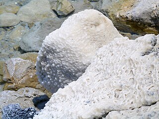
The lagoon has extensive sea grass beds and mangrove swamp. The lagoon attracts a wide variety of water birds including ducks, gulls, terns and other shorebirds.

Mangrove swamp Saline woodland or shrubland habitat formed by mangrove trees

A mangrove swamp is a distinct saline woodland or shrubland habitat formed by mangrove trees. They are characterized by depositional coastal environments, where fine sediments collect in areas protected from high-energy wave action. The saline conditions tolerated by various mangrove species range from brackish water, through pure seawater, to water concentrated by evaporation to over twice the salinity of ocean seawater.

Water bird Bird that lives on or around water

The term water bird, waterbird or aquatic bird is used to refer to birds that live on or around water. Some definitions apply the term especially to birds in freshwater habitats, though others make no distinction from birds that inhabit marine environments. In addition, some water birds are more terrestrial or aquatic than others, and their adaptations will vary depending on their environment. These adaptations include webbed feet, bills and legs adapted to feed in water, and the ability to dive from the surface or the air to catch prey in water.

Shorebirds were a short-lived Punk Rock band from Olympia, WA formed in 2007 by Mattie Jo Canino, Chris Bauermeister and Keith Henderson. The band can be considered something of a supergroup due to the band featuring members of Jawbreaker, Latterman and RVIVR.

Related Research Articles

Yala National Park national park in Sri Lanka

Yala (යාල) National Park is the most visited and second largest national park in Sri Lanka, bordering the Indian Ocean. The park consists of five blocks, two of which are now open to the public, and also adjoining parks. The blocks have individual names such as, Ruhuna National Park, and Kumana National Park or 'Yala East' for the adjoining area. It is situated in the southeast region of the country, and lies in Southern Province and Uva Province. The park covers 979 square kilometres (378 sq mi) and is located about 300 kilometres (190 mi) from Colombo. Yala was designated as a wildlife sanctuary in 1900, and, along with Wilpattu was one of the first two national parks in Sri Lanka, having been designated in 1938. The park is best known for its variety of wild animals. It is important for the conservation of Sri Lankan elephants, Sri Lankan leopards and aquatic birds.

Batticaloa City in Sri Lanka

Batticaloa is a major city in the Eastern Province, Sri Lanka, and its former capital. It is the administrative capital of the Batticaloa District. The city is the seat of the Eastern University of Sri Lanka and is a major commercial city. It is on the east coast, 111 kilometres (69 mi) south of Trincomalee, and is situated on an island. Pasikudah is popular tourist destinations situated 35 km northwest with beaches and flat year-round warm-water shallow-lagoons.

Jaffna lagoon is a large lagoon off Jaffna District and Kilinochchi District, northern Sri Lanka.

The Vanni, also spelled Wanni, is the name given to the mainland area of the Northern Province of Sri Lanka. It covers the entirety of Mannar, Mullaitivu and Vavuniya Districts, and most of Kilinochchi District, and has an area of approximately 7,650 square kilometres (2,950 sq mi). The population and infrastructure of the Vanni were devastated by the Sri Lankan Civil War.

Bundala National Park National Park in Sri Lanka

Bundala National Park is an internationally important wintering ground for migratory water birds in Sri Lanka. Bundala harbors 197 species of birds, the highlight being the greater flamingo, which migrate in large flocks. Bundala was designated a wildlife sanctuary in 1969 and redesignated to a national park on 4 January 1993. In 1991 Bundala became the first wetland to be declared as a Ramsar site in Sri Lanka. In 2005 the national park was designated as a biosphere reserve by UNESCO, the fourth biosphere reserve in Sri Lanka. The national park is situated 245 kilometres (152 mi) southeast of Colombo.

Kokkilai lagoon is an estuarine lagoon in Mullaitivu District and Trincomalee District, north-east Sri Lanka. The town of Kokkilai is located on a sand bar between the lagoon and the Indian Ocean.

Vadamarachchi lagoon is a lagoon in Jaffna District, northern Sri Lanka. The lagoon is sometimes referred to as Thondamannar lagoon. The lagoon separates the Vadamarachchi region from the Valikamam and Thenmarachchi regions.

Chundikkulam Lagoon

Chundikkulam Lagoon is a lagoon in Jaffna District and Kilinochchi District, north-east Sri Lanka. The town of Chundikkulam is located on a narrow piece of land between the lagoon and the Indian Ocean. The lagoon is sometimes referred to as Elephant Pass Lagoon.

Nai Aru Lagoon is an estuarine lagoon in Mullaitivu District, north-east Sri Lanka.

Ullackalie Lagoon is a lagoon in Trincomalee District, eastern Sri Lanka.

Upaar Lagoon is an estuarine lagoon in Batticaloa District, eastern Sri Lanka.

Batticaloa Lagoon

Batticaloa Lagoon is a very large estuarine lagoon in Batticaloa District, eastern Sri Lanka. The city of Batticaloa is located on land between the lagoon and the Indian Ocean.Batticaloa district is flourished with three lagoons, such Batticaloa lagoon, Valaichchenai Lagoon and Vakari Lagoon. Among them, Batticaloa lagoon is the largest lagoon in Batticaloa District. Batticaloa lagoon is a long and narrow lagoon situated in the east coast of Sri Lanka with the total area of approximately 11,500 ha of water.

Negombo Lagoon

Negombo Lagoon is a large estuarine lagoon in Negombo, south-west Sri Lanka.

Mundal Lagoon is a lagoon in Puttalam District, western Sri Lanka. The lagoon is sometimes referred to as Mundal Lake.

Puttalam Lagoon

The Puttalam Lagoon is a large 327 km2 (126 sq mi) lagoon in the Puttalam District, western Sri Lanka.

The Battle of Chalai was an armed confrontation over control of Chalai, Sri Lanka between the 55 Division of the Sri Lankan Military and the Liberation Tigers of Tamil Eelam (LTTE) during the Sri Lankan civil war, fought in February 2009. Chalai was the final Sea Tiger base held by the LTTE during the Northern Theater of Eelam War IV. Fighting lasted for five days, following which the 55 Division took control of the area. During the engagement, one soldier was wounded when a bomb carried by a child between 13 and 16 years of age exploded. The Sri Lankan Army indicates this suicide bomber was sent by the LTTE. Witnesses describe the boy behaving as though he had been "drugged or severely harassed before the mission."

Sarath Dissanayake Sri Lankan Navy officer

Rear Admiral Dissanayake Mudiyanselage Sarath Dissanayake RWP,RSP,VSV USP, NDU,MMS,hdmc, ADIDSM,AIMA,JP is a Sri Lankan navy officer who currently holds the position of Northern Navy Commander.

Valaichchenai Lagoon

Valaichchenai Lagoon is an estuarine lagoon in Batticaloa District, eastern Sri Lanka. Batticaloa district has three lagoons, such Valaichchenai Lagoon, Batticaloa Lagoon and Vakari Lagoon. Valaichchenai lagoon is situated in populated areas of Valaichchenai, Oddamavadi

Chundikkulam National Park

Chundikkulam National Park is a national park in northern Sri Lanka, approximately 12 km (7 mi) north east of Kilinochchi.

Malala-Ambilikala Lagoons

Malala-Ambilikala lagoons are two interconnected coastal water-bodies located inside the Bundala National Park, Hambantota District in the Southern Province, Sri Lanka. It is 260 km (160 mi) from Colombo to the arid south. The Malala-Ambilikala lagoons are two of the three key lagoons located within the Bundala Ramsar wetlands.

References