An irrigation tank or tank is an artificial reservoir of any size. In countries like Sri Lanka and India they are part of historic methods of harvesting and preserving rainwater, critical in regions without perennial water resources. A tank is often an earthen bund constructed across a long slope to collect and store surface water from the above catchment and by taking advantage of local topography. The water would be used primarily for agriculture and drinking water, but also for bathing and rituals. The word tank is the English language substitute for several vernacular terms.

Kala Wewa built by the King Datusena in 460 A.D, is a reservoir complex consisting of two reservoirs, Kala Wewa and Balalu Wewa. It has the capacity to store 123 million cubic meters of water. This reservoir complex has facilitated with a stone made spillway and three main sluices. From the central major sluice, a 40 feet wide central conveys water to feed thousands of acres of paddy lands and ends at the historical capital Anuradhapura city tank Tissa Wewa meandering over 87 km (54 mi) at a slope of 6 inches per mile and is another wonder of primeval hydraulic engineering facility in ancient Ceylon.

Victoria Dam is an arch dam located 130 mi (209 km) upstream of the Mahaweli River's mouth and 4 mi (6 km) from Teldeniya. It is named in honor of Queen Victoria of the United Kingdom.

Anuradhapura Kingdom, named for its capital city, was the first established kingdom in ancient Sri Lanka related to the Sinhalese people. According to the Mahāvaṃsa, it was founded by King Pandukabhaya in 437 BC, whose authority extended throughout the country.

Maduru Oya National Park is a national park of Sri Lanka, established under the Mahaweli development project and also acts as a catchment of the Maduru Oya Reservoir. The park was designated on 9 November 1983. Providing a sanctuary to wildlife, especially for elephants and protecting the immediate catchments of five reservoirs are the importance of the park. A community of Vedda people, the indigenous ethnic group of Sri Lanka lives within the park boundary in Henanigala. The park is situated 288 kilometres (179 mi) north-east of Colombo.
Senanayake Samudraya is the biggest reservoir and man-made lake in Sri Lanka. It is locally known as the sea. Senanayake Samudraya was opened on 28 August 1949 under the Gal Oya Multipurpose Scheme, which was completed in 1953 by D. S. Senanayake.

Abhaya Wewa, historically Abhayavapi or Bassawakkulama reservoir, is a reservoir in Sri Lanka, built by King Pandukabhaya who ruled in Anuradhapura from 437 BC to 367 BC, after constructing the city.

The Broadlands Dam is a 35 MW run-of-the-river hydroelectric complex currently under construction in Kitulgala, Sri Lanka. The project is expected to be completed in 2020, and will consist of two dams, and a power station downstream.

The Inginimitiya Dam is an embankment dam built across the Mi Oya, at Inginimitiya, Sri Lanka. Measuring 4,880 m (16,010 ft) wide and 18 m (59 ft) tall, the dam creates the popular Inginimitiya Reservoir, which is primarily used for irrigation purposes.
The Deduru Oya Dam is an embankment dam built across the Deduru River in Kurunegala District of Sri Lanka. Built in 2014, the primary purpose of the dam is to retain for irrigation purposes approximately a billion cubic metres of water, which would otherwise flow out to sea. Site studies of the dam began in 2006 and construction started in 2008. It was ceremonially completed in 2014, with the presence of then President Mahinda Rajapaksa.

The Rajanganaya Dam is an irrigation dam built across the Kala Oya river, at Rajanganaya, bordering the North Western and North Central provinces of Sri Lanka. The main concrete dam measures approximately 350 m (1,150 ft) and creates the Rajanganaya Reservoir, which has a catchment area of 76,863.60 hectares and a total storage capacity of 100.37 million cubic metres.
Iranamadu Tank is an irrigation tank in northern Sri Lanka, approximately 3 mi (5 km) south east of Kilinochchi.
Giant's Tank is an irrigation tank in northern Sri Lanka, approximately 10 mi (16 km) south east of Mannar.
Sorabora Wewa is an ancient reservoir in Mahiyangana, Badulla District Sri Lanka. It is thought to have been constructed during the reign of King Dutugemunu by a giant named Bulatha. In the ancient past, this tank was known as the 'Sea of Bintenna'.
The Mahaweli Development program is known as the largest multipurpose national development program in the history of Sri Lanka and is also considered the keystone of the government's development program that was initiated in 1961.
The Uma Oya Hydropower Complex (also internally called Uma Oya Multipurpose Development Project or UOMDP) is an irrigation and hydroelectric complex currently under construction in the Badulla District of Sri Lanka. Early assessments of project dates back to 1989, when the first studies was conducted by the country's Central Engineering and Consultancy Bureau. The complex involves building a dam across Dalgolla Oya, and channelling water over a 3,975 m (13,041 ft) tunnel to Mathatilla Oya, both of which are tributaries of the Uma Oya. At Mathatilla Oya, another dam is constructed to channel 145,000,000 m3 (5.1×10⁹ cu ft) of water per annum, via a 15,290 m (50,160 ft) headrace tunnel to the Uma Oya Power Station, where water then discharged to the Alikota Aru via a 3,335 m (10,942 ft) tailrace tunnel. The Alikota Aru is a tributary of the Kirindi Oya.

Yoda Ela or Jaya Ganga, an 87 km (54 mi) long single banking water canal carrying excess water to Tissa Wewa reservoir from Kala Wewa reservoir in Anuradhapura. The Yodha Ela is known for achieving a rather low gradient for its time. The gradient is about 10 centimetres per kilometre or 6 inches per mile.

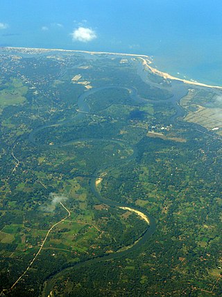
The tank cascade system is an ancient Sri Lankan irrigation infrastructure. The system is a network of small tanks draining to large reservoirs that store rainwater and surface runoff for later use. Originating in the 1st millennium BCE, the system was designated as a Globally Important Agricultural Heritage System by the United Nations Food and Agriculture Organization in 2017. Centralized bureaucratic management of large-scale systems was implemented from the 3rd to the 13th centuries.
Padaviya is a historic town in the Anuradhapura District of the North Central Province, Sri Lanka.


