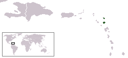

This is a list of islands of Antigua and Barbuda. Antigua and Barbuda is an archipelagic state in the Leeward Islands. There are 54 islands in the country, including three main ones. [1] [2] [3]


This is a list of islands of Antigua and Barbuda. Antigua and Barbuda is an archipelagic state in the Leeward Islands. There are 54 islands in the country, including three main ones. [1] [2] [3]

Antigua and Barbuda is a sovereign archipelagic country in the Caribbean. It lies at the conjuncture of the Caribbean Sea and the Atlantic Ocean in the Leeward Islands part of the Lesser Antilles.

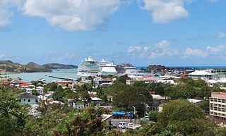
St. John's is the capital and largest city of Antigua and Barbuda, part of the West Indies in the Caribbean Sea. With a population of 22,219, St. John's is the commercial centre of the nation and the chief port of the island of Antigua.

The following is an alphabetical list of topics related to the nation of Antigua and Barbuda.

Saint John, officially the Parish of Saint John, is a civil parish of Antigua and Barbuda, on the northwestern portion of Antigua island. Its capital is the city of St. John's. Saint John borders Saint Mary, Saint Peter, Saint George, and Saint Paul. Saint John faces the Caribbean Sea. Saint John is surrounded by some of Antigua's most premier beaches. Saint John had a population of 56,736 in a 2018 estimate, making it home to the majority of the population in Antigua and Barbuda.
The Crossroads Centre is a substance-abuse rehabilitation centre for drug and alcohol addiction located on the Caribbean island of Antigua in Antigua and Barbuda.

Government House, St. John's, Antigua and Barbuda, is the official residence and office of the governor-general of Antigua and Barbuda. It was built in the 17th-century colonial style with Georgian architecture and extensive gardens. The residence is not open to the public.

Signal Hill is a mountain and the second-highest point on Antigua island, in Antigua and Barbuda.

The Shekerley Mountains are a low mountain range on southwestern Antigua island, in the nation of Antigua and Barbuda and the Leeward Islands of the eastern Caribbean.

Falmouth Harbour is a horseshoe-shaped bay and natural harbour on the far southern coast of the island of Antigua in Antigua and Barbuda.

General elections were held in Antigua and Barbuda on 17 April 1984, the first after the country had become an independent Commonwealth realm in 1981.

Antigua and Barbuda lie in the eastern arc of the Leeward Islands of the Lesser Antilles, separating the Atlantic Ocean from the Caribbean Sea. Antigua is 650 km (400 mi) southeast of Puerto Rico; Barbuda lies 48 km (30 mi) due north of Antigua, and the uninhabited island of Redonda is 56 km (35 mi) southwest of Antigua.
Ayers Creek is a stream of Antigua and Barbuda. It is located on the island of Antigua.
Cooks Creek is a stream of Antigua and Barbuda. It is located on the island of Antigua.

Fitches Creek is an affluent coastal neighbourhood in Antigua and Barbuda, located on the island of Antigua. It was named for the English surname Fitch, which may have been the family name of some who originally owned the surrounding land. The surrounding area is now a neighborhood in the parish of Saint George.
York Island is an island in the Caribbean Sea that belongs to Antigua and Barbuda. It is located east of the main island of Antigua.
Antigua State College is a public tertiary institution in Antigua and Barbuda, with 1,000 students enrolled in several programs. The college consists of several departments such as the Advanced Level, Department of business, engineering, department of undergraduate studies, teacher education (offsite) and school of pharmacy (off-site).

The Dockyard Museum is a museum located at Nelson's Dockyard in English Harbour on Antigua island, in Antigua and Barbuda.