This is a list of islands of Nicaragua. There are 160 islands in Nicaragua on both the Caribbean Sea, Pacific Ocean and inland lakes. [1]

The Arctic Archipelago, also known as the Canadian Arctic Archipelago, is an archipelago lying to the north of the Canadian continental mainland, excluding Greenland and Iceland

Villa Clara is one of the provinces of Cuba. It is located in the central region of the island bordering on the Atlantic Ocean to the north, Matanzas Province to the west, Sancti Spiritus Province to the east, and Cienfuegos Province to the South. Villa Clara shares with Cienfuegos and Sancti Spiritus on the south the Escambray Mountain Range. Its main cities are Santa Clara, Remedios, Sagua La Grande, Camajuani, Caibarién, Ranchuelo, Placetas, and Manicaragua.

The Archipelago of San Andrés, Providencia and Santa Catalina, or San Andrés and Providencia, is one of the departments of Colombia, and the only one located geographically in Central America. It consists of two island groups in the Caribbean Sea about 775 km northwest of mainland Colombia, and eight outlying banks and reefs. The largest island of the archipelago and Colombia is called San Andrés and its capital is San Andrés. The other large islands are Providencia and Santa Catalina Islands which lie to the north-east of San Andrés; their capital is Santa Isabel.

Bluefields is the capital of the South Caribbean Autonomous Region in Nicaragua. It was also the capital of the former Kingdom of Mosquitia, and later the Zelaya Department, which was divided into North and South Caribbean Coast Autonomous Regions. It is located on Bluefields Bay at the mouth of the Bluefields River in the municipality of the same name.
Mískito Coast Creole or Nicaraguan Creole English is an English-based creole language spoken in coastal Nicaraguan region of Mosquito Coast on the Caribbean Sea; its approximately 40,000 speakers are spread over the RACCN and RACCS regions of Nicaragua. The region, known before 1986 as the Zelaya department, is today administratively separated into two autonomous regions: North Caribbean Coast (RACCN) and South Caribbean Coast (RACCS). Mosquito is the nickname that is given to the region and earlier residents by early Europeans who visited and settled in the area. The term "Miskito" is now more commonly used to refer to both the people and the language.

The Corn Islands are two islands about 70 kilometres (43 mi) east of the Caribbean coast of Nicaragua, constituting one of 12 municipalities of the South Caribbean Coast Autonomous Region of Nicaragua. The official name of the municipality is Corn Island. Both Great Corn Island and Little Corn Island constitutes the archipelago of Corn Islands.

Grenadines is an administrative parish of Saint Vincent and the Grenadines, comprising the islands of the Grenadines other than those belonging to Grenada. The capital is Port Elizabeth. It's the only parish in the country that's not located on the main island.

The Miskito Cays are an archipelago of small cays and reefs with an area of 27 km2 located off Mosquito Coast in the Caribbean exclusive economic zones of Honduras and Nicaragua. They are part of the Gracias a Dios Department in Honduras and the North Caribbean Coast Autonomous Region in Nicaragua. The Miskito Cays are composed of 76 formations that include estuaries, coral reefs, cays, seagrass beds, and islets, of which 12 of the formations are covered with vegetation and consequently form islands which are lined with white sand beaches.
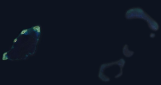
The Pearl Cays is a group of 18 cays located about 35 km (22 mi) from Pearl Lagoon off the Caribbean coast of Nicaragua. They are part of the South Caribbean Coast Autonomous Region. The Pearl Cays are covered with tropical vegetation and are lined with white sandy beaches. They are an important nesting site for turtles, including the critically endangered Hawksbill turtle.

The official language of Nicaragua is Spanish; however, Nicaraguans on the Caribbean coast speak indigenous languages and also English. The communities located on the Caribbean coast also have access to education in their native languages. Additionally, Nicaragua has four extinct indigenous languages.
Curtiss Bay is a bay about 4 nautical miles wide, indenting the west coast of Graham Land between Cape Sterneck and Cape Andreas on the Davis Coast.
Mount Mackellar is a massive mountain, 4,295 metres (14,091 ft) high, standing at the head of Mackellar Glacier, 3 nautical miles south of Pagoda Peak in the Queen Alexandra Range, Antarctica.
North Danger Reef is one of the seven major reefs / banks / etc. in the Spratly Islands area of the South China Sea. It is the most North Western of the features of the Spratly Islands, located to the NW of Dangerous Ground.
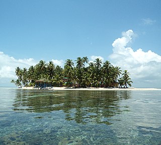
Calala Island is a private island located in the Caribbean Sea, forming part of an archipelago of islands known as the Pearl Cays, off the coast of Nicaragua.

The Cayos Miskitos-San Andrés & Providencia moist forests ecoregion cover the forested areas of four islands in the western Caribbean Sea - Cayos Miskitos and the Corn Islands off the east coast of Nicaragua, and San Andrés and Providencia Islands farther east and belonging to the nation of Colombia. The forests on San Adres and Providencia have been heavily degraded by agriculture - coconuts on San Andres, oranges on Providencia. A significant feature of the ecoregion is the surrounding corals reefs, which are large and well preserved. While not technically a part of this terrestrial ecoregion, they are related to the islands.
| Authority control databases: National |
|---|