Related Research Articles

Central America is a region of the Americas. It is bordered by Mexico to the north, Colombia to the south, the Caribbean Sea to the east, and the Pacific Ocean to the west. Central America consists of seven countries: Belize, Costa Rica, El Salvador, Guatemala, Honduras, Nicaragua, and Panama. Their combined population is estimated at 44.53 million (2016).
Nicaragua is a country in Central America, bordering both the Caribbean Sea and the North Pacific Ocean, between Costa Rica and Honduras. Nicaragua is the largest country in Central America in square kilometers.

The Petén–Veracruz moist forests is an ecoregion of the tropical and subtropical moist broadleaf forest biome found in Belize, Guatemala, and Mexico.
The Mosquitia-Nicaraguan Caribbean Coast mangroves ecoregion, in the Mangrove biome, are along the Caribbean coasts of Nicaragua, Honduras, and Costa Rica as well as off shore islands such as the Corn Islands.
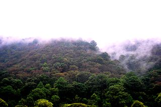
The Central American pine–oak forests ecoregion, in the tropical and subtropical coniferous forests biome, is found in Central America and Chiapas state of southern Mexico.
The Central America bioregion is a biogeographic region comprising southern Mexico and Central America.

The following outline is provided as an overview of and topical guide to Costa Rica:

The Isthmian–Atlantic moist forests (NT0129) are a Central American tropical moist broadleaf forest ecoregion located on the lowland slopes on the caribbean sea side of Nicaragua and Costa Rica and the Gulf and Pacific Ocean sides of Panama. The forest species are a mix of North American and South American, as this region only became a land bridge in the past 3 million years.

The Central American dry forests ecoregion, of the tropical and subtropical dry broadleaf forests biome, is located in Central America.

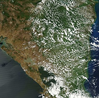
The Miskito pine forests ecoregion covers lowland pine forests and savanna along much of the Mosquito Coast in northeastern Nicaragua and southeastern Honduras. Pines are adapted to grow in the poor soil, relative to the surrounding moist forest, and repeated burning have left one species – the Caribbean pine – dominant. Although the ecoregion receives high levels of rain, the hard soils, repeated burning, and exposure to hurricanes have left expanses of 'pine savanna' and seasonal wetlands. The area is thinly settled by humans and there is little crop agriculture.

The Rio Negro-Rio San Sun mangroves ecoregion covers a series of small of discontinuous mangrove forests on the Caribbean Sea coast of Costa Rica, from a small portion inside the border with Nicaragua in the west to the border with Panama in the east. The coast on this stretch is a flat, alluvial plain, and mangroves are only a small part of a diverse patchwork of local habitats including swamps, mixed rainforests, coastal lagoons, sea grass beds, and sandy beaches. Much of the territory is "blackwater river" in character - slow-moving channels in wooded swamps with water stained by decayed matter. These mangroves are periodically damaged by hurricanes, such as in 1988 from Hurricane Joan, but are able to regenerate.

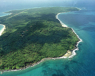
The Cayos Miskitos-San Andrés & Providencia moist forests ecoregion cover the forested areas of four islands in the western Caribbean Sea - Cayos Miskitos and the Corn Islands off the east coast of Nicaragua, and San Andrés and Providencia Islands farther east and belonging to the nation of Colombia. The forests on San Adres and Providencia have been heavily degraded by agriculture - coconuts on San Andres, oranges on Providencia. A significant feature of the ecoregion is the surrounding corals reefs, which are large and well preserved. While not technically a part of this terrestrial ecoregion, they are related to the islands.
References
- ↑ "Cayos Miskitos-San Andrés and Providencia moist forest". World Wildlife Fund. Retrieved 2013-09-24.
- ↑ "Central American Atlantic moist forests". World Wildlife Fund. Retrieved 2013-09-24.
- ↑ "Central American montane forests". World Wildlife Fund. Retrieved 2013-09-24.
- ↑ "Costa Rican seasonal moist forests". World Wildlife Fund. Retrieved 2013-09-24.
- ↑ "Isthmian-Atlantic moist forests". World Wildlife Fund. Retrieved 2013-09-24.
- ↑ "Central American dry forests". World Wildlife Fund. Retrieved 2013-09-24.
- ↑ "Central American pine-oak forests". World Wildlife Fund. Retrieved 2013-09-24.
- ↑ "Miskito pine forests". World Wildlife Fund. Retrieved 2013-09-24.
- ↑ "Gulf of Fonseca mangroves". World Wildlife Fund. Retrieved 2013-09-24.
- ↑ "Mosquitia-Nicaraguan Caribbean Coast mangroves". World Wildlife Fund. Retrieved 2013-09-23.
- ↑ "Southern Dry Pacific Coast mangroves". World Wildlife Fund. Retrieved 2013-09-24.
- ↑ "Rio Negro-Rio San Sun mangroves". World Wildlife Fund. Retrieved 2013-09-24.
- ↑ "Chiapas - Fonseca". Freshwater Ecoregions of the World. Archived from the original on 2013-09-24. Retrieved 2013-09-24.
- ↑ "Mosquitia". Freshwater Ecoregions of the World. Archived from the original on 2013-09-24. Retrieved 2013-09-24.
- ↑ "Estero Real - Tempisque". Freshwater Ecoregions of the World. Archived from the original on 2013-09-24. Retrieved 2013-09-24.
- ↑ "San Juan (Nicaragua/Costa Rica)". Freshwater Ecoregions of the World. Archived from the original on 2013-09-24. Retrieved 2013-09-24.
- 1 2 "Marine Ecoregions (Spalding 2007). [Map by] GEOMAR, University of Seville, Department of Human Geography". Marine ecoregions. marineplan.es. Archived from the original (jpg) on 2017-02-12. Retrieved 2013-09-26.
!["Marine Ecoregions (Spalding 2007). [Map by] GEOMAR, University of Seville, Department of Human Geography"](https://web.archive.org/web/20170212110426/http://www.marineplan.es/ES/fichas_kml/mapasfichas/ecoregions.jpg)