
Newport County is one of five counties located in the U.S. state of Rhode Island. As of the 2020 census, the population was 85,643. It is also one of the seven regions of Rhode Island. The county was created in 1703. Like all of the counties in Rhode Island, Newport County no longer has any governmental functions. All of those functions in Rhode Island are now carried out either by the state government, or by the cities and towns of Rhode Island. Newport County is included in the Providence-Warwick, RI-MA Metropolitan Statistical Area, which is in turn constitutes a portion of the greater Boston-Worcester-Providence, MA-RI-NH-CT Combined Statistical Area.

Narragansett Bay is a bay and estuary on the north side of Rhode Island Sound covering 147 square miles (380 km2), 120.5 square miles (312 km2) of which is in Rhode Island. The bay forms New England's largest estuary, which functions as an expansive natural harbor and includes a small archipelago. Small parts of the bay extend into Massachusetts.
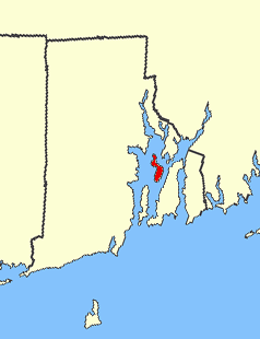
Prudence Island is the third-largest island in Narragansett Bay in the state of Rhode Island and part of the town of Portsmouth, Rhode Island, United States. It is located near the geographic center of the bay. It is defined by the United States Census Bureau as Block Group 3, Census Tract 401.03 of Newport County, Rhode Island. As of the 2010 census, the population was 278 people living on a land area of 14.43 km2.

The Colony of Rhode Island and Providence Plantations was one of the original Thirteen Colonies established on the east coast of America, bordering the Atlantic Ocean. It was founded by Roger Williams. It was an English colony from 1636 until 1707, and then a colony of Great Britain until the American Revolution in 1776, when it became the State of Rhode Island and Providence Plantations.
Narragansett Bay divides the state of Rhode Island into two parts. The term East Bay refers to communities on the east side of the bay, including Bristol, Warren, Barrington, Tiverton, Little Compton, Newport, Middletown, Portsmouth and Jamestown. The city of East Providence is commonly included, especially the community of Riverside. The term West Bay refers to communities on the west side of the bay, such as Warwick, Cranston and East Greenwich. Jamestown and the towns on Aquidneck Island are sometimes known as "The Islands" along with Block Island.

Riverside is a neighborhood in the city of East Providence in the U.S. state of Rhode Island. Despite not being an incorporated city, Riverside has its own zip code, 02915, and is an acceptable mailing address according to the United States Postal Service. Riverside has a population of approximately 20,000 people.
The Stewart B. McKinney National Wildlife Refuge is a 950-acre (384.5 ha) National Wildlife Refuge in ten units across the U.S. state of Connecticut. Located in the Atlantic Flyway, the refuge spans 70 miles (110 km) of Connecticut coastline and provides important resting, feeding, and nesting habitat for many species of wading birds, shorebirds, songbirds and terns, including the endangered roseate tern. Adjacent waters serve as wintering habitat for brant, scoters, American black duck, and other waterfowl. Overall, the refuge encompasses over 900 acres (364.2 ha) of barrier beach, intertidal wetland and fragile island habitats.

Hope Island is a 91-acre (0.368 km2) island located in Narragansett Bay in the State of Rhode Island. It is part of the Narragansett Bay National Estuarine Research Reserve, along with nearby Prudence Island and Patience Island, and home to colonial wading birds during their nesting season of spring and summer.

Patience Island lies off the northwest coast of Prudence Island in the town of Portsmouth, Rhode Island. It has a land area of 0.33 sq mi, making it the fourth-largest island in Narragansett Bay. Aside from a single 600-square foot house, which is disconnected from the state electrical grid, Patience Island is otherwise uninhabited.
Dyer Island is an island in Narragansett Bay in Rhode Island, United States. It lies off the west coast of Aquidneck Island and is part of Melville CDP, which itself is part of the town of Portsmouth. The island lies between Melville and Prudence Island and is uninhabited and has a land area of 0.12 km² and is only 13 feet above sea level.
Despair Island is a small island in Narragansett Bay in Newport County, Rhode Island. It is located between Hope Island and Prudence Island. The island is composed of many outcroppings of rocks used extensively by nesting birds, such as gulls and terns.

Whale Rock or Submarine Rock is the smallest island in Narragansett Bay in Rhode Island. It is located in the West Passage of the bay in Narragansett, Washington County, Rhode Island, west of the Beavertail area on Conanicut Island. The island received its names because it is shaped like a whale's back or a submarine's bow. It was responsible for numerous shipwrecks prior to the construction of a lighthouse. Whale Rock Light was built on the rock in 1882; it was destroyed by the 1938 New England hurricane, which also claimed the life of keeper Walter Eberle. Part of the lighthouse's foundation can still be seen.
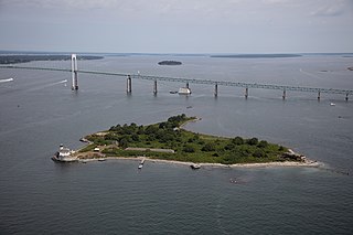
Coasters Harbor Island is a 92-acre (370,000 m2) island in Narragansett Bay, Newport, Rhode Island. The island is home to the Naval War College (NWC), an education and research institution of the United States Navy that specializes in developing ideas for naval warfare and passing them along to officers of the Navy.
Rose Island is an 18.5-acre (7.5 ha) island in Narragansett Bay off Newport, Rhode Island, United States. It is allegedly named "Rose Island" because at low tide the island appears to be shaped like a rose. The Island is only accessible by boat. The island and its lighthouse are run by the private, non-profit Rose Island Lighthouse Foundation.
The South County History Center, which formerly operated as the Pettaquamscutt Historical Society, is a nonprofit organization in Kingston, Rhode Island, United States, that preserves and interprets the material culture of South County through exhibits and study of archival, library and artifact collections.
In the late 19th century, many Portuguese, mainly from the islands of Azores and Madeira, migrated to the United States and established communities in cities such as New Bedford, Massachusetts; and San Jose, California. Many of them also moved to Hawaii. There are an estimated 1,500,000 Portuguese Americans based on the Government Census Community Survey.

The Tavern Hall Preservation Society is a not-for-profit corporation dedicated to the preservation and upkeep of the Elisha Reynolds House (1738) in Kingston, Rhode Island. The society was founded as the Tavern Hall Club in 1911 to foster understanding and cooperation between the people of the Village of Kingston and the nearby Rhode Island State College community.

Washington County, known locally as South County, is a county located in the U.S. state of Rhode Island. As of the 2020 census, the population was 129,839. Rhode Island counties have no governmental functions other than as court administrative boundaries, which are part of the state government.

The Hannah Robinson Tower is a 40 feet (12 m) tall wooden tower at the interchange between U.S. Route 1 and Route 138 in the community of South Kingstown, South County, Rhode Island. The tower was built in 1938 by the Civilian Conservation Corps and was rebuilt in 1988 using the same pillars. The structure is named after Hannah Robinson (1746–1773), a colonial Rhode Island resident and daughter of a wealthy Narragansett society man, Rowland Robinson. Hannah fell in love with a local teacher, Peter Simon, but the relationship was deemed unsuitable by her father. Despite her father's disapproval, Hannah Robinson married her suitor and lived in Providence, Rhode Island. The family became estranged from Robinson, who was enveloped in poverty, leading to a fatal decline. Robinson's father ended his opposition and left his community of Boston Neck to bring Hannah home. As Rowland Robinson brought his daughter home, she requested a chance to visit nearby McSparran Hill, where she considered a view of her homeland. Robinson died soon after.