Related Research Articles

There are 137 local government areas (LGAs) in Western Australia, which comprise 27 cities, 102 shires, and 8 towns that manage their own affairs to the extent permitted by the Local Government Act 1995. The Local Government Act 1995 also makes provision for regional local governments (referred to as "regional councils", established by two or more local governments for a particular purpose.

The City of Wanneroo is a local government area with city status in the northern suburbs of Perth, Western Australia. It is centred approximately 25 kilometres (15.5 mi) north of Perth's central business district and forms part of the northern boundary of the Perth metropolitan area. Wanneroo encompasses the federal divisions of Cowan, Moore and Pearce.

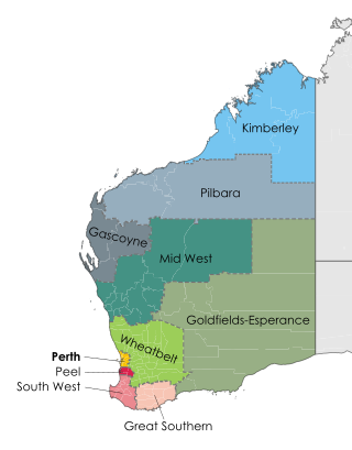
The Wheatbelt is one of nine regions of Western Australia defined as administrative areas for the state's regional development, and a vernacular term for the area converted to agriculture during colonisation. It partially surrounds the Perth metropolitan area, extending north from Perth to the Mid West region, and east to the Goldfields–Esperance region. It is bordered to the south by the South West and Great Southern regions, and to the west by the Indian Ocean, the Perth metropolitan area, and the Peel region. Altogether, it has an area of 154,862 square kilometres (59,793 sq mi).
Karratha is a city in the Pilbara region of Western Australia, adjoining the port of Dampier. It was established in 1968 to accommodate the processing and exportation workforce of the Hamersley Iron mining company and, in the 1980s, the petroleum and liquefied natural gas operations of the North West Shelf Venture. As of the 2021 census, Karratha had an urban population of 17,013. The city's name comes from the cattle station of the same name, which derives from a word in a local Aboriginal language meaning "good country" or "soft earth". The city is the seat of government of the City of Karratha, a local government area covering the surrounding region.
SmartRider is the contactless electronic ticketing system of the Public Transport Authority of Western Australia. The system uses RFID smartcard technology to process public transport fares across public bus, train and ferry services.

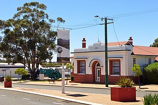
Broomehill is a town on the Great Southern Highway between Katanning and Albany, in the Great Southern region of Western Australia. Its local government area is the Shire of Broomehill-Tambellup.
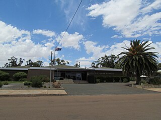
The Shire of Dowerin is a local government area in the Wheatbelt region of Western Australia, about 160 kilometres (100 mi) northeast of Perth, the state capital. The Shire covers an area of 1,847 square kilometres (713 sq mi) and its seat of government is the town of Dowerin.

The Shire of Broome is one of the four local government areas in the Kimberley region of northern Western Australia, covering an area of 55,796 square kilometres (21,543 sq mi), most of which is sparsely populated. The Shire's estimated population as at the 2016 census was 16,222 most of whom reside in the town of Broome. Many Aboriginal communities are within the Shire, notably Beagle Bay and Bardi.
The Shire of Gnowangerup is a local government area in the Great Southern region of Western Australia, about 120 kilometres (75 mi) north of Albany and about 370 kilometres (230 mi) southeast of the capital, Perth. The Shire covers an area of 4,268 square kilometres (1,648 sq mi), and its seat of government is the town of Gnowangerup.
Pilbara newspapers is a selection of newspapers published in the Pilbara region of Western Australia.

Railways in Perth, the capital city of Western Australia, have existed since 1881, when the Eastern Railway was opened between Fremantle and Guildford. Today, Perth has seven Transperth commuter rail lines and 75 stations.

Transperth is the public transport system for Perth and surrounding areas in Western Australia. It is managed by the Public Transport Authority (PTA), a state government organisation, and consists of train, bus and ferry services. Bus operations are contracted out to Swan Transit, Path Transit and Transdev. Ferry operations are contracted out to Captain Cook Cruises. Train operations are done by the PTA through their Transperth Train Operations division.
Western Australia has the longest coastline of any state or territory in Australia, at 10,194 km or 12,889 km. It is a significant portion of the coastline of Australia, which is 35,877 km.
The Shire of Broomehill-Tambellup is a local government area in the Great Southern region of Western Australia, 320 kilometres (200 mi) south-southeast of the state capital, Perth. The Shire covers an area of 2,609.1 square kilometres (1,007.4 sq mi), and its seat of government is the town of Tambellup. It came into existence in 2008 through the amalgamation of the former Shire of Broomehill and Shire of Tambellup.

The Division of Durack is an Australian Electoral Division in the state of Western Australia.

The Great Southern Herald is a weekly newspaper published in Katanning, Western Australia. It is distributed to communities in Katanning, Kojonup, Cranbrook, Gnowangerup and Lake Grace.
References
- 1 2 "Libraries - Visit us". Murdoch University. Retrieved 2024-05-20.
- ↑ "Regional WA Library Consortium". City of Albany Libraries. Retrieved 2024-05-21.
- ↑ "Spydus WA regional library consortium is now the largest in Australia". Civica. Retrieved 2024-05-21.
- ↑ "Albany Public Library | State Library of Western Australia". slwa.wa.gov.au. Retrieved 2024-05-21.
- ↑ "Opening Hours & Locations » City of Albany Library". library.albany.wa.gov.au. Retrieved 2024-05-21.
- ↑ "Denmark Public Library". www.denmark.wa.gov.au. Retrieved 2024-05-21.
- ↑ "Library Services » Shire of Plantagenet". www.plantagenet.wa.gov.au. Retrieved 2024-05-21.
- ↑ "One library card, 11 libraries to choose from". Bunbury Mail. 2016-08-02. Retrieved 2024-05-21.
- 1 2 "Western Australian Public Libraries: Our Future" (PDF). State Library of Western Australia.
- 1 2 "Our Councils » The Grove Library". www.thegrovelibrary.net. Retrieved 2024-05-21.
- ↑ "Libraries | City of Mandurah". www.mandurah.wa.gov.au. Retrieved 2024-05-21.
- ↑ "Community Resource Centre and Public Library » Shire of Dowerin". www.dowerin.wa.gov.au. Retrieved 2024-05-21.
- ↑ "Libraries - Gingin & Lancelin » Shire of Gingin". www.gingin.wa.gov.au. Retrieved 2024-05-21.
- ↑ "Libraries – City of Joondalup" . Retrieved 2024-05-21.
- ↑ "Library » Shire of West Arthur". www.westarthur.wa.gov.au. Retrieved 2024-05-21.
- ↑ "Library » Shire of Upper Gascoyne". www.uppergascoyne.wa.gov.au. Retrieved 2024-05-21.
- ↑ "Public Library - Shire of Halls Creek". www.hallscreek.wa.gov.au. Retrieved 2024-05-21.
- ↑ "Libraries | Karratha Council". libraries.karratha.wa.gov.au. Retrieved 2024-05-21.