Mountain ranges of Mexico
Baja California
| | This section is empty. You can help by adding to it. (January 2011) |
Baja California Sur
| | This section is empty. You can help by adding to it. (January 2011) |
A List of mountain ranges of the Sonoran Desert. Many of the mountains of southern Arizona are included, excluding the Madrean Sky Island ranges of southeast Arizona, extreme southwest New Mexico, or northeast Sonora, Mexico.
The Mojave Desert lies to the northwest; also in the northwest and west are mountain ranges of the lower elevation Colorado Desert, (west of the north-south section of the Colorado River of the Lower Colorado River Valley, in the southeast California deserts.)
Mountain ranges on the Baja California Peninsula east of the cordillera spine mountains are included. The middle section of the peninsula is the Vizcaino Desert ; a few ranges are from the very south in Baja California Sur.
| | This section is empty. You can help by adding to it. (January 2011) |
| | This section is empty. You can help by adding to it. (January 2011) |
The mostly east-west flowing Bill Williams River forms the northern border of La Paz County, Arizona with Mohave County to the north. This is an approximate delimiting line between the Mojave Desert north and northwest, and to the Sonoran Desert to the south, east, and southeast. The Colorado Desert-(subsection of the Sonoran) lies across the Colorado River to the west, but intergrades into the higher elevation Mojave Desert northwestwards.
On Eastern border of Sonoran Desert-(Madrean Sky Island)

The Sonoran Desert is a North American desert and ecoregion that covers part of the southwestern United States, as well as the northwestern Mexican states of Sonora, Baja California, and Baja California Sur. It is the hottest desert in both Mexico and the United States. It has an area of 260,000 square kilometers (100,000 sq mi).
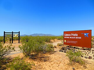
Cabeza Prieta National Wildlife Refuge (CPNWR) is located in southwestern Arizona in the United States, along 56 miles (90 km) of the Mexico–United States border. It is bordered to the north and to the west by the Barry M. Goldwater Air Force Range, to the south by Mexico's El Pinacate y Gran Desierto de Altar Biosphere Reserve, to the northeast by the town of Ajo, and to the southeast by Organ Pipe Cactus National Monument.

The Kofa Mountains of Yuma and La Paz counties in Arizona is the central mountain range of the Kofa National Wildlife Refuge. The range lies about 60 miles northeast of Yuma in the southwestern part of the state. Kofa Wilderness takes up 547,719 acres of the refuge, making it the second largest wilderness area in Arizona. The equally extensive Castle Dome Mountains comprise the southern refuge border; the western end of the Tank Mountains are in the southeast of the wildlife refuge, and the New Water Wilderness in the New Water Mountains ends the extension of the Kofa National Wildlife Refuge to the north. Scenic "King Valley" is south of the Kofa Mountains between the Castle Dome Mountains.
The Tank Mountains are a mountain range in the Sonoran Desert of southwest Arizona; the range is part of the southeastern border of the Kofa National Wildlife Refuge.
The Bryan Mountains are a small mountain range in the northwestern Sonoran Desert of southwestern Arizona. The range is located in southeastern Yuma County, about 75 mi southeast of Yuma and about 35 mi west of Ajo. The range is approximately ten miles long and about three miles wide at its widest point. The highpoint of the range is 1,794 feet above sea level and is located at 32°18'27"N, 113°22'46"W. The range is located entirely within the Cabeza Prieta National Wildlife Refuge.
The Hyder Valley is a 20-mile (32 km) long valley section of the Gila River Valley west of Hyder on the Gila River. The valley is located north of Gila River in southwest Arizona in the northwestern Sonoran Desert. The Park Valley, which crosses the Gila borders to the southwest; the Hyder Valley is the access route to the Dendora Valley northeast which is on the western border of the Painted Rock Dam and Reservoir.
The Harcuvar Mountains are a narrow mountain range in western-central Arizona, United States. The range lies just east of the north-south Colorado River, and south of the east-west, west-flowing Bill Williams River, from Alamo Lake.
Butler Valley is a valley of the Maria fold and thrust belt in western Arizona, USA. It lies east of the Colorado River, and is south of the west-flowing Bill Williams River.
The Little Harquahala Mountains are a small, arid, low-elevation mountain range of western-central Arizona, in the southeast of La Paz County.

The Granite Wash Mountains are a short, arid, low elevation mountain range of western-central Arizona, in the southeast of La Paz County. The range borders a slightly larger range southeast, the Little Harquahala Mountains; both ranges form a section on the same water divide between two desert washes. The washes flow in opposite directions, one northwest to the Colorado River, the other southeast to the Gila River.
The West Silver Bell Mountains are a small 10 mile (16 km) long mountain range of south-central Arizona, United States. The range lies in the north-central arid Sonoran Desert; the Madrean Sky Islands region of southeast Arizona, around Tucson is adjacent to the southeast.
The Date Creek Mountains are a short, arid range in southwest Yavapai County, Arizona. Congress is on its southeast foothills, and Wickenburg lies 15 mi (24 km) southeast.

The Arizona/New Mexico Mountains ecoregion is a Level III ecoregion designated by the United States Environmental Protection Agency (EPA) in the U.S. states of Arizona and New Mexico.