A crossing of the North American continental divide is necessary for any transcontinental railroad in North America, and has always been one of the hardest obstacles. This article lists such crossings from north to south.
Location | Province(s) | Elevation | Built by | Current/Last | Years of operation | Notes |
---|---|---|---|---|---|---|
west of O'Dell | British Columbia | 747 m (2,451 ft) | Pacific Great Eastern Railway | Canadian National Railway | 1967–present | First of two crossings, about 4 miles apart, on CN Stuart Sub |
south of Summit Lake | British Columbia | 716 m (2,349 ft) | Pacific Great Eastern Railway | Canadian National Railway | 1967–present | Second of two crossings on CN Stuart Sub |
east of Summit Lake | British Columbia | 728 m (2,388 ft) | Pacific Great Eastern Railway | Canadian National Railway | 1958–present | |
Yellowhead Pass | Alberta and British Columbia | 1,110 m (3,642 ft) | Canadian Northern Railway and Grand Trunk Pacific Railway | Canadian National Railway | 1914–present | Originally two lines. GTP built 1914, CNoR built 1915. Consolidated into one line in 1917, with some adjustments in 1924 |
Kicking Horse Pass | Alberta and British Columbia | 1,627 m (5,338 ft) | Canadian Pacific Railway | Canadian Pacific Railway | 1884–present | |
Crowsnest Pass | Alberta and British Columbia | 1,358 m (4,455 ft) | Canadian Pacific Railway | Canadian Pacific Railway | 1897–present |
Location | State(s) | Elevation | Built by | Currently | Years of operation | Notes |
---|---|---|---|---|---|---|
Marias Pass | Montana | 5,213 ft (1,589 m) | Great Northern Railway | BNSF Railway | 1893–present | Hi-Line |
Mullan Pass | Montana | 5,566 ft (1,697 m) | Northern Pacific Railroad | Montana Rail Link | 1883–present | Passes through the Mullan Tunnel |
Elk Park Pass | Montana | 6,365 ft (1,940 m) | Great Northern Railway | Burlington Northern Railroad | 1888–1972 | |
Homestake Pass | Montana | 6,328 ft (1,929 m) | Northern Pacific Railroad | BNSF Railway | 1888–present (dormant since 1983) | |
Pipestone Pass | Montana | 6,347 ft (1,935 m) | Chicago, Milwaukee, St. Paul and Pacific Railroad | Chicago, Milwaukee, St. Paul and Pacific Railroad | 1909–1980 | Passed through the Pipestone Pass Tunnel |
Deer Lodge Pass | Montana | 5,801 ft (1,768 m) | Utah and Northern Railway | Union Pacific Railroad | 1881–present | Narrow gauge until 1887; railroad name Feely |
Bannock Pass | Montana and Idaho | 7,575 ft (2,309 m) | Gilmore and Pittsburgh Railroad | Gilmore and Pittsburgh Railroad | 1910–1939 | Tunnel at summit |
Monida Pass | Montana and Idaho | 6,823 ft (2,080 m) | Utah and Northern Railway | Union Pacific Railroad | 1880–present | Narrow gauge until 1886 |
Reas Pass | Montana and Idaho | 6,930 ft (2,112 m) | Union Pacific Railroad | Union Pacific Railroad | 1905–1981 | Branch to West Yellowstone |
South Pass | Wyoming | 7,420 ft (2,262 m) [1] | U.S. Steel | U.S. Steel | 1962–1983 | Served U.S. Steel Atlantic City Ore Mine |
Robinson | Wyoming | 6,940 ft (2,115 m) | Union Pacific Railroad | Union Pacific Railroad | 1868–present | Two sides of the Great Divide Basin; Robinson is the true Divide (per USGS) |
Hadsell | Wyoming | 6,930 ft (2,112 m) | ||||
Rollins Pass | Colorado | 11,660 ft (3,554 m) (1904), 9,239 ft (2,816 m) (1928) | Denver, Northwestern and Pacific Railway | Union Pacific Railroad | 1904–present | Original alignment replaced in 1928 by the Moffat Tunnel ) |
Jones Pass | Colorado | 8,964 ft (2,732 m) [2] | Henderson Mine | 1976–1999 | Narrow gauge, passed through the Henderson Tunnel; replaced by a conveyor belt; elevation is for west (and only) portal | |
Boreas Pass | Colorado | 11,493 ft (3,503 m) | Denver, South Park and Pacific Railroad | Colorado and Southern Railway | 1882–1937 | Narrow gauge |
Fremont Pass | Colorado | 11,319 ft (3,450 m) | Denver, South Park and Pacific Railroad | Colorado and Southern Railway | 1884–1937 | Narrow gauge. Line south of Climax retained, converted to standard gauge 1943, now operated by Leadville, Colorado and Southern Railroad |
Fremont Pass | Colorado | 11,330 ft (3,453 m) | Denver and Rio Grande Railroad | Denver and Rio Grande Western Railroad | 1881–1923 | Narrow gauge |
Tennessee Pass | Colorado | 10,424 ft (3,177 m) | Denver and Rio Grande Railroad | Denver and Rio Grande Railroad | 1887–1890 | Narrow gauge, replaced by standard gauge Tennessee Pass Tunnel |
Tennessee Pass | Colorado | 10,239 ft (3,121 m) (1890), 10,221 ft (3,115 m) (1945) | Denver and Rio Grande Railroad | Union Pacific Railroad (dormant) | 1890–present (dormant since 1997) | Passed through the Tennessee Pass Tunnel (original tunnel built 1890, replaced in 1945) |
Hagerman Pass | Colorado | 11,528 ft (3,514 m) (1887),10,953 ft (3,338 m) (1893) | Colorado Midland Railway | Colorado Midland Railway | 1887–1918 | Passed through the Hagerman Tunnel, replaced in 1893 by the Busk-Ivanhoe Tunnel. Reverted to original route between 1897 and 1899 |
Alpine Tunnel | Colorado | 11,612 ft (3,539 m) | Denver, South Park and Pacific Railroad | Colorado and Southern Railway | 1881–1910 | Narrow gauge |
Marshall Pass | Colorado | 10,856 ft (3,309 m) | Denver and Rio Grande Railroad | Denver and Rio Grande Western Railroad | 1881–1953 | Narrow gauge. Original D&RG mainline before Tennessee Pass line opened |
Azotea | New Mexico | 7,773 ft (2,369 m) | Denver and Rio Grande Railroad | Denver and Rio Grande Western Railroad | 1880–1968 | Narrow gauge |
Hillcrest | New Mexico | 7,714 ft (2,351 m) | Rio Grande and Southwestern Railroad | Rio Grande and Southwestern Railroad | 1903–1924 | Narrow gauge |
Campbell Pass | New Mexico | 7,244 ft (2,208 m) | Atchison, Topeka and Santa Fe Railway | BNSF Railway | 1882–present | |
Tyrone | New Mexico | 5,990 ft (1,826 m) | Burro Mountain Railroad | Southwestern Railroad | Serves Phelps Dodge copper pit; short tunnel under Divide | |
Wilna | New Mexico | 4,584 ft (1,397 m) | Southern Pacific Railroad | Union Pacific Railroad | 1883–present | Lordsburg Subdivision |
Hachita | New Mexico | 4,495 ft (1,370 m) | Arizona and New Mexico Railroad | Southern Pacific Railroad | 1902–1934 | |
Vista | New Mexico | 4,650 ft (1,417 m) (east), 4,694 ft (1,431 m) (west) | El Paso and Southwestern Railroad | Southern Pacific Railroad | 1902–1961 | Two crossings 2 miles apart |
(name unknown) | New Mexico | 4,525 ft (1,379 m) | Phelps Dodge | Phelps Dodge | 1970s–1999 | Line served Hidalgo Smelter |
Antelope | New Mexico | 4,510 ft (1,375 m) | El Paso and Southwestern Railroad | Southern Pacific Railroad | 1902–1961 | |
Location | State(s) | Elevation | Built by | Currently | Years of operation | Notes |
---|---|---|---|---|---|---|
Divisadero | Chihuahua | 2,270 m (7,448 ft) | Ferrocarriles Nacionales de México | Ferromex | 1961–present | |
Francisco I. Madero | Durango | 2,000 m (6,562 ft) | Ferrocarril Coahuila Durango | 1892–present | ||
Niza Conejo Chivela Pass | Oaxaca | 224 m (735 ft) [3] | Ferrocarril Nacional de Tehuantepec | Ferroistmo | 1894–present | |
Location | Elevation | Built by | Current or last operator | Years of operation | Notes |
---|---|---|---|---|---|
Chato Guatemala | International Railways of Central America (div. of United Fruit) | FEGUA [4] | 1908–1996 | ||
Ochomogo Pass Costa Rica | 1,500 metres (4,900 ft) | Incofer | 1870s [5] –1991 [6] | 9°53′55″N83°56′42″W / 9.898637°N 83.945031°W | |
Culebra Cut Panama | 80.4 metres (264 ft) | Panama Railroad Company | Panama Canal Railway Company (div. of Kansas City Southern Railway) | 1855–present | 9°3′24″N79°38′20″W / 9.05667°N 79.63889°W |
The Ecocanal is a proposal to build a rail line across Nicaragua from Monkey Point on the Caribbean to Corinto on the Pacific. [7] If built, the rail line will cross the continental divide in Nicaragua, likely at a point north of Lake Nicaragua.
The Encyclopædia Britannica Eleventh Edition (1910–1911) is a 29-volume reference work, an edition of the Encyclopædia Britannica. It was developed during the encyclopaedia's transition from a British to an American publication. Some of its articles were written by the best-known scholars of the time. This edition of the encyclopaedia, containing 40,000 entries, has entered the public domain and is easily available on the Internet. Its use in modern scholarship and as a reliable source has been deemed problematic due to the outdated nature of some of its content. Modern scholars have deemed some articles as cultural artifacts of the 19th and early 20th centuries.
The Kingdom of France was organised into provinces until the National Constituent Assembly adopted a more uniform division into departments (départements) and districts in late 1789. The provinces continued to exist administratively until 21 September 1791.
The Sunda Islands are a group of islands in the Malay Archipelago. They consist of the Greater Sunda Islands and the Lesser Sunda Islands
French Somaliland was a French colony in the Horn of Africa. It existed between 1884 and 1967, at which time it became the French Territory of the Afars and the Issas. The Republic of Djibouti is its legal successor state.
Following is a list of dates in the history of Sunderland, the ancient city in North East England. Facts and figures, important dates in Sunderland's history.
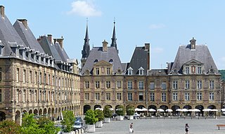
Charleville-Mézières is a commune of northern France, capital of the Ardennes department, Grand Est. Charleville-Mézières is located on the banks of the river Meuse.
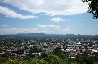
Corinto is a town, with a population of 18,602, on the northwest Pacific coast of Nicaragua in the province of Chinandega. The municipality was founded in 1863.
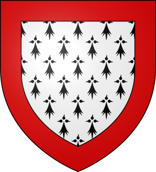
The history of Limousin, one of the traditional provinces of France, reaches back to Celtic and Roman times. The region surrounds the city of Limoges. Limousin is located in the foothills of the western edge of the Massif Central, with cold weather in the winter. Its name is derived from the name of a Celtic tribe, the Lemovices, whose main sanctuary was recently found in Tintignac and became a major site for Celtic study which were found such as the carnyces in the whole Celtic world.
Sonsonate is a city and municipality of El Salvador. Of which it is also its head. It has an estimated population of 72,158 inhabitants for the year 2013, Sonsonate is the second most important city in western El Salvador.The town was founded under the name of "Villa del Espíritu Santo" on vacant lots near the town of los Izalcos in 1552.5 However, this foundation would be extremely ephemeral, because the following year, in 1553, this villa would be transferred to its current location, with the name of "Villa de la Santísima Trinidad de Sonsonate", in a cocoa-producing area. With the passage of time, the town would be known simply by the name of Sonsonate. This name was taken from the Rio Grande or Sonsonate in the Nahuat language, which crosses it from north to south across the entire plain until it flows into the Pacific Ocean. This was the third Spanish population founded in the territories that currently constitute El Salvador, although, it is worth clarifying, during the entire period of Spanish domination of America, Sonsonate was the capital of the Mayor's Office of Sonsonate, a territory apart from the one administered by San Salvador., today the capital of El Salvador.
Thomas Belt, an English geologist and naturalist, was born at Newcastle-on-Tyne in 1832, and educated in that city. He is remembered for his work on the geology of gold bearing minerals, glacial geology, and for his description of the mutualistic relationship between certain bullthorn Acacia species and their Pseudomyrmex ants.
Hagen-Haspe is a borough of the city of Hagen in the state of North Rhine-Westphalia, Germany. It is located in the valley of the Ennepe at the confluence of the Hasper.
The Cordillera de Talamanca is a mountain range that lies in the southeast half of Costa Rica and the far west of Panama. Much of the range and the area around it is included in La Amistad International Park, which also is shared between the two countries.
Rail transport in Costa Rica is primarily under the stewardship of Incofer, an autonomous institution of the state. Incofer owns the national railway infrastructure and operates virtually all freight and passenger services, which consist primarily of commuter trains through the highly populated Central Valley. The whole Incofer network is 1,067 mm narrow gauge, although there are several small tourist railways of other gauges.
Charles II Francis of Austria was an Archduke of Austria and a ruler of Inner Austria from 1564. He was a member of the House of Habsburg.
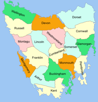
The Lands administrative divisions of Tasmania are the divisions of Tasmania into land districts and parishes for cadastral purposes, which are part of the lands administrative divisions of Australia. There are 20 land districts in Tasmania, although in the early nineteenth century there were several other systems, with 18 or 36 counties and 9 other divisions used, as well as hundreds. The land districts include the 18 former counties of the island of Tasmania which were renamed but retain the same boundaries, plus King Island and Flinders Island. The counties are referenced in the 1911 Encyclopædia Britannica, with Hobart described as being in Buckingham County, Launceston in Cornwall County and Beaconsfield in Devon County. The land districts are used for land titles today, while the Local Government Areas of Tasmania with cities and municipalities are used for political and administrative purposes.
Totonicapán is a city in Guatemala. It serves as the capital of the department of Totonicapán and as the administrative seat for the surrounding municipality of Totonicapán.
La Veta Pass is the name associated with two nearby mountain passes in the Sangre de Cristo Mountains of south central Colorado in the United States, both lying on the boundary between Costilla and Huerfano counties.
Deer Lodge Pass, elevation 5,879 ft (1,792 m), is a mountain pass on the Continental Divide in southwestern Montana, about 11 miles southwest of Butte. It is traversed by Interstate 15 and is one of three crossings of the Divide by I-15, the others being Monida Pass and Elk Park Pass north of Butte. Unlike most other passes in western Montana, Deer Lodge Pass is in the midst of treeless, rolling hills, and the grades on the highway are relatively gentle.
Ochomogo is a location in the province of Cartago, Costa Rica. It is in a mountain pass between the cities of San José and Cartago. It was the site of the Battle of Ochomogo between those who wanted Costa Rica to join the newly formed First Mexican Empire and those who preferred independence.