Listed buildings in Gringley on the Hill

Last updated

Gringley on the Hill is a civil parish in the Bassetlaw District of Nottinghamshire, England. The parish contains 23 listed buildings that are recorded in the National Heritage List for England. Of these, one is listed at Grade II*, the middle of the three grades, and the others are at Grade II, the lowest grade. The parish contains the village of Gringley on the Hill and the surrounding countryside. Most of the listed buildings are houses, cottages and associated structures, farmhouses and farm buildings. The other listed buildings include a church and a former chapel, a village cross, a canal milepost, a former windmill and a war memorial.

Contents

Key

Map all coordinates using: OpenStreetMap  
Download coordinates as: KML
GradeCriteria [1]
II*Particularly important buildings of more than special interest
IIBuildings of national importance and special interest

Buildings

Name and locationPhotographDateNotesGrade
St Peter and St Paul's Church
53°24′28″N0°53′40″W / 53.40768°N 0.89441°W / 53.40768; -0.89441 (St Peter and St Paul's Church)
Church of St Peter and St Paul, Gringley on the Hill - geograph.org.uk - 4242486.jpg
13th centuryThe church has been altered and extended through the centuries, and the south aisle was added in 1910–1912. It is built in stone, partly rendered and pebbledashed, and has slate roofs. The church consists of a nave with a clerestory, north and south aisles, a chancel and a west tower. The tower has two stages, diagonal buttresses, two string courses, and a moulded embattled parapet with corner crocketed pinnacles. On the west side is a 14th-century doorway with a chamfered surround, above which is a triple lancet window and stair lights, on the north side is a blocked round-headed Norman doorway, and the upper stage contains two-light bell openings with hood moulds. [2] [3] II*
Village cross
53°24′29″N0°53′43″W / 53.40793°N 0.89524°W
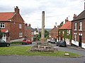
 / 53.40793; -0.89524 (Village Cross)
The Market Cross, Gringley on the Hill - geograph.org.uk - 520308.jpg
14th centuryThe cross stands at a road junction. It is about 7 feet (2.1 m) high, and consists of a broken octagonal shaft with a square base, on a square plinth of four steps. There is a niche on the east side. [4] [5] II
The Rood House
53°24′28″N0°53′42″W / 53.40786°N 0.89500°W / 53.40786; -0.89500 (The Rood House)
c. 1730The house is in brick with a floor band, an eaves band, cogged eaves, and a pantile roof with coped tumbled gables. There are two storeys and an L-shaped plan, with a front of three bays, the left bay gabled, and a rear wing. On the front is a doorway with a reeded surround and a fanlight, and in the angle at the rear is a porch. The windows are a mix, and include fixed lights, casements and sashes, some of the latter horizontally-sliding. [6] II
Park House Farmhouse
53°24′27″N0°54′32″W / 53.40760°N 0.90891°W / 53.40760; -0.90891 (Park House Farmhouse)
Mill Hill past Park house Farm - geograph.org.uk - 4493036.jpg
18th centuryThe farmhouse is in brick with stone dressings, cogged and dentilled eaves, and a pantile roof with a coped tumbled gable. There are two storeys and three bays. The central doorway has plain jambs and a segmental head, and the windows are sashes. [7] II
The Green, conservatory and wall
53°24′23″N0°53′10″W / 53.40649°N 0.88599°W / 53.40649; -0.88599 (The Green, conservatory and wall)
18th centuryA brick farmhouse on a plinth, with a floor band, an eaves band, cogged eaves, and slate roofs with coped and tumbled gables. There are two storeys and a main range of five bays. In the centre is a doorway with a decorated moulded surround and a triple-octagon fanlight, and the windows are sashes. To the left is an extension with two storeys, a single bay, and a conservatory on the front, and beyond that are two further two-storey single-bay extensions. At the rear is a round-headed doorway with a fanlight containing Gothic tracery. The windows in the extension and at the rear are a mix of casements and horizontally-sliding sashes. The boundary wall is in brick with stone coping, it is ramped, and contains a doorway with a gable. [8] II
The Homestead
53°24′39″N0°53′35″W / 53.41083°N 0.89319°W / 53.41083; -0.89319 (The Homestead)
The Homestead, Gringley - geograph.org.uk - 4242206.jpg
Mid 18th centuryThe farmhouse is in brick with a cogged and dentilled eaves band, and a pantile roof with coped and tumbled gables. There are two storeys and attics and three bays, and a later two-storey two-bay wing to the south. The doorway on the front has a fanlight, and the windows are sashes; all the openings have segmental heads. At the rear is a doorway with a reeded surround and a pediment. [9] II
1 High Street
53°24′28″N0°53′44″W / 53.40782°N 0.89551°W / 53.40782; -0.89551 (1 High Street)
Smith's House - geograph.org.uk - 4242219.jpg
Late 18th centuryA house that was later extended, it is in brick on a rendered plinth, with stone dressings, a floor band, an eaves band, cogged and dentilled eaves, and a pantile roof with cogged and tumbled gables. There are two storeys and attics, and four bays. On the front are two doorways, the right doorway with a fanlight. The windows are sashes. [10] II
Pigeoncote, stables and granary,
Church Farm
53°24′27″N0°53′39″W / 53.40743°N 0.89428°W / 53.40743; -0.89428 (Pigeoncote, stables and granary, Church Farm)
Buildings at Church Farm - geograph.org.uk - 2744574.jpg
Late 18th centuryThe farm buildings are in brick with pantile roofs. The pigeoncote has an eaves band, cogged eaves, brick coped gables, three stages, a square plan and a single bay. It contains a stable door and casement windows, above which is a door with a segmental head, and in the top stage are four tiers of pigeon holes. The attached stable and granary have two storeys and three bays. They contain various openings, some with segmental heads, and there is an external flight of steps and a round-headed kennel. [4] [11] II
Gringley Grange Farm House
53°24′19″N0°52′13″W / 53.40523°N 0.87017°W
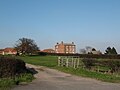
 / 53.40523; -0.87017 (Gringley Grange Farm House)
Gringley Grange near Gringley on the Hill - geograph.org.uk - 377683.jpg
Late 18th centuryThe farmhouse is in brick with stone dressings, an eaves band, cogged eaves, and a pantile roof. There are two storeys and attics, and an L-shaped plan, with a front range of three bays, and a wing and a later extension at the rear. The central doorway has a plain surround and a fanlight, and the windows are sashes with splayed lintels. [12] II
Ravenhill and wall
53°24′30″N0°53′30″W / 53.40841°N 0.89156°W / 53.40841; -0.89156 (Ravenhill and wall)
Ravenhill, High Street, Gringley - geograph.org.uk - 4242498.jpg
Late 18th centuryThe house, which was later heightened and extended, is in brick with floor bands, dentilled eaves and pantile roofs. There are two storeys and attics, and an L-shaped plan with a south front of six irregular bays. On the front are two canted bay windows, most of the other windows are sashes, some with segmental heads, and there are gabled dormers. At the rear is a three-storey stair turret. The boundary wall is in brick with stone coping, on which there is about 10 metres (33 ft) of ornate cast iron railings, and the wall contains a boarded gate. [13] II
North Beeches and South Beeches
53°24′29″N0°53′19″W / 53.40796°N 0.88874°W / 53.40796; -0.88874 (North Beeches and South Beeches)
North Beeches and South Beeches, High Street, Gringley - geograph.org.uk - 4242507.jpg
c. 1790A house that was extended to the right in the 19th century. It is stuccoed, and has a floor band, moulded eaves and a hipped slate roof. There are two storeys, and an L-shaped plan with a main range of six bays. On the main front is a doorway with pilasters, a fanlight, a frieze and a moulded hood, flanked by caned bay windows, and above are three sash windows with stuccoed architraves. The extension has a French window and sash windows. In the south front are two doorways with moulded architraves, sash windows and a conservatory. [14] II
Gringley Hall and boundary wall
53°24′27″N0°53′46″W / 53.40751°N 0.89610°W / 53.40751; -0.89610 (Gringley Hall and boundary wall)
Gringley Hall - geograph.org.uk - 3406546.jpg
c. 1800The house is in rendered brick with stone dressings and a hipped slate roof. There are two storeys and attics, a main block with a square plan and sides of three bays, a single-bay extension to the right, and a later flat-roofed extension to the left. The doorway in the east front has Doric columns, and a round-headed opening with a fanlight. In the south front are two canted bay windows, and the other windows are sashes. The boundary wall is in red brick with ramped stone coping, and it contains two square stone gate piers, with recessed panels and pyramidal caps, and between them is a pair of Gothic cast iron gates. [4] [15] II
Canal milepost
53°25′10″N0°53′25″W / 53.41951°N 0.89019°W / 53.41951; -0.89019 (Canal milepost)
Old milemarker by Shaw Lock, Chesterfield Canal (geograph 6076504).jpg
Late 18th to early 19th centuryThe milepost is on the south side of the Chesterfield Canal near Shaw Lock. It consists of a stone slab post with a rounded head inscribed '42', indicating the distance from Chesterfield. [16] II
Bleak House
53°24′29″N0°53′33″W / 53.40813°N 0.89254°W
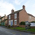
 / 53.40813; -0.89254 (Bleak House)
Bleak House, High Street, Gringley - geograph.org.uk - 4242496.jpg
Early 19th centuryA brick house with stone dressings and a pantile roof. There are two storeys and three bays. The central doorway has a doorcase in glass fibre, with a moulded surround, a fanlight and a hood. The windows are sashes with channelled wedge lintels and keystones. [17] II
Cross Hill Cottage
53°24′29″N0°53′42″W / 53.40803°N 0.89507°W / 53.40803; -0.89507 (Cross Hill Cottage)
Cross Hill Cottage - geograph.org.uk - 4242227.jpg
Early 19th centuryThe house is in brick on a rendered plinth, with stone dressings, dentilled eaves and a pantile roof. There are two storeys and three bays. The central doorway has pilasters and a frieze, and the windows are sashes|sashes. All the openings have rendered wedge lintels. [18] II
Pigeoncote, Gringley Vicarage
53°24′28″N0°53′43″W / 53.40782°N 0.89522°W / 53.40782; -0.89522 (Pigeoncote, Gringley Vicarage)
Former dovecote at Gringley on the Hill - geograph.org.uk - 2701397.jpg
Early 19th centuryThe pigeoncote is in brick, with a floor band, an eaves band, cogged eaves, and a pantile roof with tumbled coped gables. There are two storeys, a square plan and a single bay. The openings have segmental heads, and there are two tiers of pigeonholes. [19] II
Prospect House and wall
53°24′31″N0°53′27″W / 53.40852°N 0.89094°W / 53.40852; -0.89094 (Prospect House and wall)
Prospect House, Horsewells Street - geograph.org.uk - 4242500.jpg
Early 19th centuryThe house is in brick, rendered and colourwashed, with stone dressings, an eaves band, cogged eaves, and a pantile roof with coped gables. There are two stories and attics, and an L-shaped plan, with a front range of three bays and a later rear extension. In the centre is a porch with a moulded hood and a door with a fanlight. The windows on the front are sashes with keystones, and elsewhere there are casement windows. The boundary wall is in brick, it is ramped, with stone coping, and contains two square brick piers and an iron gate. [20] II
Gringley Windmill
53°24′26″N0°54′11″W / 53.40727°N 0.90306°W / 53.40727; -0.90306 (Gringley Windmill)
Gringley on the Hill windmill - geograph.org.uk - 4242599.jpg
c. 1830The former windmill is in brick with dentilled eaves, and consists of a circular tapering tower. It has four stages, and contains a doorway and casement windows, all with segmental heads. [4] [21] II
Mill House
53°24′27″N0°54′12″W / 53.40754°N 0.90321°W / 53.40754; -0.90321 (Mill House)
Mill House, Gringley - geograph.org.uk - 4242607.jpg
c. 1830The house is in brick, mainly rendered, with stone dressings, dentilled eaves and a hipped pantile roof. There are two storeys and an L-shaped plan, with a main range of three bays and a single-storey single-bay extension. The doorway has a rendered architrave and a fanlight, and the windows are a mix of sashes and casements, some with segmental heads, and there is a round-headed stair window. [22] II
Vicarage and boundary wall
53°24′27″N0°53′41″W / 53.40754°N 0.89486°W
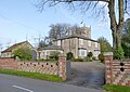
 / 53.40754; -0.89486 (Gringley Vicarage and boundary wall)
The Old Rectory, Gringley - geograph.org.uk - 4242209.jpg
c. 1837The vicarage is in gault and red brick, with details in stone and stucco, and a hipped slate roof. There are two storeys, a main block with a square plan and sides of three bays, and a single-storey single-bay extension on the left. In the centre is a doorway with a moulded surround, an entablature and a moulded hood. It is flanked by square bay windows, and the other windows are sashes with rendered lintels. The boundary wall is in gault brick with patterning in red brick, cross-shaped openings, and terracotta coping. It contains three square piers with square stone caps, and a pair of gate piers with recessed panels and pyramidal stone caps. [4] [23] II
Sunday School
53°24′32″N0°53′45″W / 53.40902°N 0.89587°W / 53.40902; -0.89587 (Sunday School)
The old Primitive Methodist Chapel - geograph.org.uk - 4242536.jpg
1838Originally a Methodist chapel, the building is in brick on a stone plinth, and has a pantile roof with coped gables and kneelers. There is a single storey, two bays, and a rear lean-to extension. On the front is a central doorway and sash windows, all with segmental heads. Above the doorway is an inscribed and dated plaque, and the southeast corner of the building is canted and corbelled. [4] [24] II
Coach house, Gringley Vicarage
53°24′28″N0°53′43″W / 53.40771°N 0.89531°W / 53.40771; -0.89531 (Coach house, Gringley Vicarage)
Former coach house to The Old Rectory - geograph.org.uk - 4242217.jpg
Mid 19th centuryThe former coach house is in brick, with a floor band, cogged eaves, and a pantile roof with coped gables. There are two storeys and three bays. The building contains two elliptical carriage openings, a stable door with a segmental head, and other openings, some blocked. [25] II
War memorial
53°24′27″N0°54′09″W / 53.40749°N 0.90246°W / 53.40749; -0.90246 (War memorial)
Gringley War Memorial - geograph.org.uk - 4242627.jpg
1920The war memorial is in the cemetery, and consists of a cross in Portland stone. This has an octagonal shaft with a carved sword, and stands on a hexagonal plinth on a projecting base. On the plinth are inscriptions and the names of those lost in the two World Wars. [26] II

Related Research Articles

Ripley is a civil parish in the Amber Valley district of Derbyshire, England. The parish contains 62 listed buildings that are recorded in the National Heritage List for England. Of these, five are listed at Grade II*, the middle of the three grades, and the others are at Grade II, the lowest grade. The parish contains the town of Ripley, smaller settlements including Ambergate, Bullbridge, Butterley, Fritchley, Heage, Nether Heage and Waingroves, and the surrounding countryside. The Cromford Canal, now partly closed, runs through the parish, and the listed buildings associated with it are bridges and an embankment. Also running through the parish is a railway that originated as the North Midland Railway with a later branch, the Manchester, Buxton, Matlock and Midland Junction Railway, and associated with these are bridges, viaducts, a goods shed, and the portals of a tunnel. Most of the other listed buildings are houses, cottages and associated structures, farmhouses and farm buildings. The other listed buildings include churches, a windmill, a pair of coke iron furnaces, factory buildings, public houses, mileposts, colliery buildings, a railway station and signal box at Butterley, and a war memorial.

South Normanton is a civil parish in the Bolsover District of Derbyshire, England. The parish contains eight listed buildings that are recorded in the National Heritage List for England. Of these, two are listed at Grade II*, the middle of the three grades, and the others are at Grade II, the lowest grade. The parish contains the village of South Normanton and the surrounding area, and the listed buildings consist of a country house and its coach house, a church, a former windmill, a former farmhouse, a school and two mileposts.

Swarkestone is a civil parish in the South Derbyshire district of Derbyshire, England. The parish contains 19 listed buildings that are recorded in the National Heritage List for England. Of these, one is listed at Grade I, the highest of the three grades, three are at Grade II*, the middle grade, and the others are at Grade II, the lowest grade. The parish contains the village of Swarkestone and the surrounding area. The Trent and Mersey Canal passes through the northern part of the parish, and the listed buildings associated with it are bridges, a lock, mileposts, and a former toll house with an outbuilding. The other listed buildings include houses and associated structures, farmhouses and farm buildings, a church and a cross in the churchyard, a public house and its former stable block, and former reading rooms.

Wormhill is a civil parish in the High Peak district of Derbyshire, England. The parish contains 26 listed buildings that are recorded in the National Heritage List for England. Of these, three are listed at Grade II*, the middle of the three grades, and the others are at Grade II, the lowest grade. The parish contains the village of Wormhill and the surrounding area. Most of the listed buildings are houses, cottages and associated structures, farmhouses and farm buildings. The other listed buildings include a church and associated structures, a village cross moved into the churchyard, a railway viaduct, and a memorial fountain.

Barnby in the Willows is a civil parish in the Newark and Sherwood district of Nottinghamshire, England. The parish contains six listed buildings that are recorded in the National Heritage List for England. Of these, one is listed at Grade I, the highest of the three grades, and the others are at Grade II, the lowest grade. The parish contains the village of Barnby in the Willows and the surrounding countryside. The listed buildings consist of a church, a circular dovecote, a public house, a village hall and two houses.

Worksop is a market town in the Bassetlaw District of Nottinghamshire, England. The town contains over 100 listed buildings that are recorded in the National Heritage List for England. Of these, four are listed at Grade I, the highest of the three grades, five are at Grade II*, the middle grade, and the others are at Grade II, the lowest grade. The most important listed buildings are a former priory, later a parish church, the gatehouse to the priory, a lodge, and a country house, which are listed at Grade I, and structures associated with them are also listed. Most of the other listed buildings include houses, cottages and associated structures, shops, offices, farmhouses and farm buildings, public houses and hotels, public buildings and churches. The rest of the listed buildings include a market cross, a canal lock, schools, a bank, a railway station and a signal box, a pumping station, war memorials and a telephone kiosk.

Beckingham is a civil parish in the Bassetlaw District of Nottinghamshire, England. The parish contains 15 listed buildings that are recorded in the National Heritage List for England. Of these, one is listed at Grade II*, the middle of the three grades, and the others are at Grade II, the lowest grade. The parish contains the village of Beckingham and the surrounding countryside. Most of the listed buildings are houses, farmhouses and associated structures, and the others include a church and its churchyard wall, three buildings associated with Beckingham railway station, and a war memorial.

Besthorpe is a civil parish in the Newark and Sherwood district of Nottinghamshire, England. The parish contains eleven listed buildings that are recorded in the National Heritage List for England. All the listed buildings are designated at Grade II, the lowest of the three grades, which is applied to "buildings of national importance and special interest". The parish contains the village of Besthorpe and the surrounding countryside, and the listed buildings consist of houses, farmhouses and associated structures, two churches, and a former post mill.

Bleasby is a civil parish in the Newark and Sherwood district of Nottinghamshire, England. The parish contains nine listed buildings that are recorded in the National Heritage List for England. Of these, one is at Grade II*, the middle of the three grades, and the others are at Grade II, the lowest grade. The parish contains the villages of Bleasby and Goverton and the surrounding area, and the listed buildings consist of a church and its former vicarage, other houses, one with an attached pump, a pigeoncote, and a war memorial.

Carlton-on-Trent is a civil parish in the Newark and Sherwood district of Nottinghamshire, England. The parish contains 16 listed buildings that are recorded in the National Heritage List for England. Of these, two are at Grade II*, the middle of the three grades, and the others are at Grade II, the lowest grade. The parish contains the village of Carlton-on-Trent and the surrounding area. All the listed buildings are in the village, and consist of houses, cottages and associated structures, farmhouses and farm buildings, and a church.

Clayworth is a civil parish in the Bassetlaw District of Nottinghamshire, England. The parish contains 18 listed buildings that are recorded in the National Heritage List for England. Of these, one is listed at Grade I, the highest of the three grades, and the others are at Grade II, the lowest grade. The parish contains the village of Clayworth and the surrounding area. The Chesterfield Canal runs through the parish, and the listed buildings associated with it are a bridge, a warehouse and two mileposts. The other listed buildings consist of houses, cottages and associated structures, farmhouses and farm buildings, a former chapel, and a church and monuments in the churchyard.

Clumber and Hardwick is a civil parish in the Bassetlaw District of Nottinghamshire, England. The parish contains 26 listed buildings that are recorded in the National Heritage List for England. Of these, one is listed at Grade I, the highest of the three grades, six are at Grade II*, the middle grade, and the others are at Grade II, the lowest grade. The parish contains Clumber Park, the grounds of the former Clumber Park House, and the settlement of Hardwick Village. The listed buildings in Clumber Park include the surviving range of the house, the stable range, a stable courtyard and former vicarage, the kitchen gardens and a palm house, a church, a bridge, two temples, a grotto, gateways and lodges. In the village are houses, farm buildings and a war memorial.

East Bridgford is a civil parish in the Rushcliffe district of Nottinghamshire, England. The parish contains 20 listed buildings that are recorded in the National Heritage List for England. Of these, one is listed at Grade I, the highest of the three grades, and the others are at Grade II, the lowest grade. The parish contains the village of East Bridgford and the surrounding area. The listed buildings consist of houses and associated structures, farmhouses and farm buildings, a church and headstones in the churchyard, a former windmill, and a war memorial.

East Markham is a civil parish in the Bassetlaw District of Nottinghamshire, England. The parish contains 21 listed buildings that are recorded in the National Heritage List for England. Of these, one is listed at Grade I, the highest of the three grades, and the others are at Grade II, the lowest grade. The parish contains the village of East Markham and the surrounding countryside. Most of the listed buildings are houses, cottages and associated structures, farmhouses and farm buildings, including three pigeoncotes. The other listed buildings consist of a church, a pinfold, a former windmill, a school and a war memorial.

Epperstone is a civil parish in the Newark and Sherwood district of Nottinghamshire, England. The parish contains 22 listed buildings that are recorded in the National Heritage List for England. Of these, one is listed at Grade I, the highest of the three grades, and the others are at Grade II, the lowest grade. The parish contains the village of Epperstone and the surrounding countryside. Most of the listed buildings are houses, cottages and associated structures, farmhouses and farm buildings, including three pigeoncotes. The other listed buildings include a church, a former chapel, a former mill, a pinfold, a former library and a telephone kiosk.

Everton is a civil parish in the Bassetlaw District of Nottinghamshire, England. The parish contains 23 listed buildings that are recorded in the National Heritage List for England. Of these, one is listed at Grade II*, the middle of the three grades, and the others are at Grade II, the lowest grade. The parish contains the village of Everton and the surrounding countryside. Most of the listed buildings are houses, cottages, farmhouses, and associated structures. The other listed buildings consist of a church, a monument in the churchyard, a former malthouse, a canal milepost, a former windmill, a war memorial and a telephone kiosk.

Farndon is a civil parish in the Newark and Sherwood district of Nottinghamshire, England. The parish contains 19 listed buildings that are recorded in the National Heritage List for England. Of these, one is listed at Grade I, the highest of the three grades, and the others are at Grade II, the lowest grade. The parish contains the village of Farndon and the surrounding area. Most of the listed buildings are houses, cottages, farmhouses, and associated structures. The other listed buildings are a church and a former windmill.

Flintham is a civil parish in the Rushcliffe district of Nottinghamshire, England. The parish contains 38 listed buildings that are recorded in the National Heritage List for England. Of these, two are listed at Grade I, the highest of the three grades, and the others are at Grade II, the lowest grade. The parish contains the village of Flintham and the surrounding area. The most important buildings in the parish are a church and the country house, Flintham Hall, which are both listed at Grade I. A number of structures associated with the hall are listed, and the other listed buildings consist of houses, cottages and associated structures, farmhouses and farm buildings, a pinfold, a former school and a telephone kiosk.

Grassthorpe is a civil parish in the Newark and Sherwood district of Nottinghamshire, England. The parish contains five listed buildings that are recorded in the National Heritage List for England. All the listed buildings are designated at Grade II, the lowest of the three grades, which is applied to "buildings of national importance and special interest". The parish contains the village of Grassthorpe and the surrounding countryside. The listed buildings consist of a house, a cottage, a pigeoncote, a footbridge and a pinfold.

Greasley is a civil parish in the Borough of Broxtowe, Nottinghamshire, England. The parish contains 30 listed buildings that are recorded in the National Heritage List for England. Of these, two are listed at Grade II*, the middle of the three grades, and the others are at Grade II, the lowest grade. The parish contains the settlements of Beauvale, Moorgreen and Watnall and the surrounding area. Most of the listed buildings are houses, cottages and associated structures, farmhouses and farm buildings. The others include the remains of a fortified manor house, a church and a former chapel, and a school.

References

Citations

Sources