Listed buildings in Hartington Nether Quarter

Last updated

Hartington Nether Quarter is a civil parish in the Derbyshire Dales district of Derbyshire, England. The parish contains 24 listed buildings that are recorded in the National Heritage List for England. Of these, one is listed at Grade II*, the middle of the three grades, and the others are at Grade II, the lowest grade. The parish is mainly rural, to the east of the village of Hartington, and it contains the settlements of Biggin, Friden, Heathcote, Newhaven and Pikehall. Most of the listed buildings are houses, cottages, farmhouses, and associated structures, and the others are a hotel, a church, and two mileposts.

Contents

Key

Map all coordinates using: OpenStreetMap  
Download coordinates as: KML
GradeCriteria [1]
II*Particularly important buildings of more than special interest
IIBuildings of national importance and special interest

Buildings

Name and locationPhotographDateNotesGrade
Biggin Hall
53°07′59″N1°46′29″W / 53.13303°N 1.77465°W / 53.13303; -1.77465 (Biggin Hall)
c. 1642A house, later a hotel, it is in limestone with gritstone dressings, quoins, and a slate roof with coped gables and moulded kneelers. There are two storeys and attics, a front of two bays, and a stair turret at the rear. The doorway has a massive rusticated quoined surround. The windows are mullioned and most have lights with segmental heads. [2] [3] II*
Newhaven House Hotel
53°08′15″N1°45′12″W / 53.13759°N 1.75327°W / 53.13759; -1.75327 (Newhaven House Hotel)
The disused Newhaven House Hotel, Newhaven - geograph.org.uk - 3161842.jpg
Mid 18th centuryThe former hotel, which was extended in about 1795, is in rendered stone on a shallow plinth, with painted dressings, rusticated quoins, decorated bands, and slate roofs, hipped at the front and with coped gables at the rear. There are thee storeys, an east front of five bays, and eight bays on the south front. The right three bays of the south front are canted, to the left is a range of three bays, and a lower range of two bays. On the east front is a central porch with a broken dentilled pediment flanked by porticos with Doric columns. The windows are sashes. [4] [5] II
Stable, Pikehall Farm
53°07′46″N1°42′54″W / 53.12956°N 1.71500°W / 53.12956; -1.71500 (Stable, Pikehall Farm)
Mid 18th centuryThe stable range is in limestone with gritstone dressings, quoins, and a corrugated asbestos roof with coped gables and kneelers. There are two storeys and an L-shaped plan, with two ranges at right angles, and a later single-storey six-bay range to the east. The openings include two doorways with massive quoins and lintels, stable doors, and casement windows, and in the angle is a flight of external steps. [6] II
Hilltop Farmhouse
53°08′19″N1°46′56″W / 53.13873°N 1.78234°W
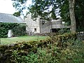
 / 53.13873; -1.78234 (Hilltop Farmhouse)
Heathcote - geograph.org.uk - 1346908.jpg
c. 1700The farmhouse has a timber framed core with cruck construction, it was encased in stone and extended in the 18th century, and a rear wing was added in the 19th century. The house is rendered and has a tile roof. There are two storeys, four bays, and a rear wing. The windows are casements, and in the rear wing are quoins. [7] [8] II
Biggin Grange and wall
53°07′41″N1°46′53″W / 53.12818°N 1.78141°W / 53.12818; -1.78141 (Biggin Grange and wall)
Late 18th centuryThe farmhouse, which was extended at the rear in the 19th century, is in limestone with gritstone dressings, quoins, a projecting eaves band, and a slate roof with coped gables and plain kneelers. There are two storeys, an L-shaped plan, and five bays. The central doorway has a quoined surround and a large fanlight, and the windows are sashes, the central window in the upper floor with a keystone. The garden wall has gritstone coping, and contains tall piers with moulded cornices, one with an acorn finial. [9] II
Cottages west of Highfield House
53°07′51″N1°45′51″W / 53.13073°N 1.76420°W / 53.13073; -1.76420 (Cottages west of Highfield House)
Late 18th centuryA pair of cottages in rendered stone with gritstone dressings and a stone slate roof. There are two storeys, and each cottage has a single bay. The right doorway has a quoined surround, and the left doorway has incised jambs with corner circles, and a flat hood. There is one sash window, and the other windows are mullioned with two lights, and contain casements. [10] II
Pikehall Farmhouse
53°07′45″N1°42′52″W / 53.12918°N 1.71443°W / 53.12918; -1.71443 (Pikehall Farmhouse)
Late 18th centuryThe farmhouse is in limestone with gritstone dressings, quoins, and a stone slate roof with coped gables and moulded kneelers. There are two storeys and three bays. The doorway has a rusticated quoined surround, and the windows either have a single light, or are mullioned and contain two casements. [11] II
Smithy Farmhouse and Blacksmiths
53°07′54″N1°45′22″W / 53.13166°N 1.75612°W / 53.13166; -1.75612 (Smithy Farmhouse and Blacksmiths)
Late 18th centuryA farmhouse and smithy in limestone with gritstone dressings, quoins, and a slate roof with coped gables and plain kneelers. The farmhouse has two storeys and three bays, and the smithy to the east has a single storey and two bays. The doorways have plain surrounds and the windows are mullioned. [12] II
Upperhouse Farmhouse
53°07′48″N1°43′34″W / 53.12993°N 1.72609°W / 53.12993; -1.72609 (Upperhouse Farmhouse)
1779The farmhouse is in limestone with gritstone dressings, quoins and a slate roof. There are two storeys and three bays. On the front are two doorways with quoined surrounds, one with a dated quoin, and the windows are mullioned and contain casements. [13] II
Newhaven House Farmhouse
53°08′16″N1°45′12″W / 53.13780°N 1.75331°W / 53.13780; -1.75331 (Newhaven House Farmhouse)
c. 1795An outbuilding, later a farmhouse, in stone with gritstone dressings, quoins, a string course, a hipped slate roof, and two storeys. The doorways have quoined surrounds, one has a rectangular fanlight, and the windows are top-hung casements. [14] II
Stable block and coach house northwest of Newhaven House Hotel
53°08′16″N1°45′13″W / 53.13776°N 1.75369°W / 53.13776; -1.75369 (Stable block and coach house northwest of Newhaven House Hotel)
c. 1795The buildings are in rendered limestone with gritstone dressings, quoins, and a hipped slate roof. There are two storeys and five bays, the middle bay projecting under a coped gable. This bay contains a semicircular archway, blocked above the impost level, and is flanked by doorways with quoined surround. Elsewhere, there are more doorways with quoined surrounds, hayloft doors, and a single-light window. [4] [15] II
Stable block north of Newhaven House Hotel
53°08′17″N1°45′13″W / 53.13795°N 1.75349°W / 53.13795; -1.75349 (Stable block north of Newhaven House Hotel)
c. 1795The stable block is in rendered limestone with gritstone dressings, quoins, and a corrugated iron roof. There are two storeys and four bays, and a brick lean-to on the east end. The building contains doorways with quoined surrounds, a single-light window, and hayloft openings [4] [16] II
Station House
53°08′38″N1°44′47″W / 53.14384°N 1.74626°W / 53.14384; -1.74626 (Station House)
c. 1825The house is in limestone with gritstone dressings, rusticated quoins, an eaves band, and a slate roof. There are two storeys and three bays. In the centre is a porch, above it is a single-light window, and the other windows are mullioned with hood moulds. [17] II
Bank House
53°07′34″N1°45′13″W / 53.12600°N 1.75356°W / 53.12600; -1.75356 (Bank House)
Bank House, near Biggin.jpg
Early 19th centuryA farmhouse, at one time a coaching inn, it is in rendered stone with gritstone dressings, quoins, a plain eaves band, and a hipped tile roof. There are three storeys and three bays. In the centre is a limestone porch with a coped gable, and a ball and steeple finial. On the front is a sash window, above which is an armorial shield inscribed with initials and a date. The other windows on the front are also sashes, and on the south front are two-light mullioned windows. [18] II
Friden Grange
53°08′38″N1°44′56″W / 53.14382°N 1.74891°W / 53.14382; -1.74891 (Friden Grange)
Early 19th centuryA farmhouse in limestone with painted stone dressings and a stone slate roof. There are three bays, the middle bay projecting, with two storeys and an attic, and the outer bays have two storeys. The recessed doorway has a fanlight and a bracketed hood. The windows vary; some are mullioned, there are sash windows, some have single lights, and some have hood moulds. [19] II
Hand Dale Farmhouse
53°08′50″N1°46′47″W / 53.14730°N 1.77970°W / 53.14730; -1.77970 (Hand Dale Farmhouse)
Hand Dale Farm - geograph.org.uk - 3463687.jpg
Early 19th centuryThe farmhouse is in limestone with gritstone dressings, quoins, a plain eaves band, and a stone slate roof with coped gables and plain kneelers. There are two storeys and two bays. The doorway has a quoined surround, and the windows are mullioned with two-lights and top-hung casements. [20] II
Heathcote Farm
53°08′21″N1°46′59″W / 53.13909°N 1.78311°W
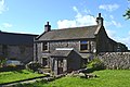
 / 53.13909; -1.78311 (Heathcote Farm)
"Kirkham" - farmhouse in the hamlet of Heathcote - geograph.org.uk - 3161694.jpg
Early 19th centuryA farmhouse in limestone, partly rendered, with gritstone dressings, quoins, and a stone slate roof with coped gables and plain kneelers. There are two storeys and two bays. In the centre is a lean-to porch, over which is an oval plaque, and the windows are replacement casements. [21] II
Ivy House
53°07′54″N1°45′16″W / 53.13177°N 1.75445°W / 53.13177; -1.75445 (Ivy House)
Ivy House, near Biggin.jpg
Early 19th centuryA limestone farmhouse with gritstone dressings, quoins, an eaves cornice, and a pyramidal hipped slate roof. There are two storeys and three bays, and a single-storey two-bay wing on the left. In the centre of the main block is a porch with four pilasters around panels, and a round-headed doorway with a divided fanlight and a cornice. The windows are sashes. [22] II
Barns and stables,
Ivy House Farm
53°07′54″N1°45′14″W / 53.13170°N 1.75388°W / 53.13170; -1.75388 (Barns and stables, Ivy House Farm)
Early 19th centuryThe barns and stables are in limestone with gritstone dressings, quoins, and a hipped slate roof with some asbestos sheeting. There are two storeys, and the buildings form a U-shaped plan. The openings include doorways with quoined surrounds, some of which are blocked, and hayloft doors, and there is a flight of external steps. [23] II
Yew Tree Cottage
53°07′57″N1°46′29″W / 53.13251°N 1.77465°W / 53.13251; -1.77465 (Yew Tree Cottage)
Early 19th centuryA limestone house with gritstone dressings, quoins, and a slate roof with moulded gable copings and kneelers. There are two storeys and two bays. The doorway has a plain surround, and the windows are mullioned with moulded surrounds, and contain two casements. [24] II
St Thomas' Church, Biggin
53°07′52″N1°46′15″W / 53.13112°N 1.77082°W / 53.13112; -1.77082 (St Thomas' Church, Biggin)
St Thomas' Church, Biggin.jpg
1844–48The church, designed by E. H. Shellard in Decorated style, is in limestone with gritstone dressings and a slate roof. It consists of a nave, a south porch, a chancel, and a west tower. The tower has three stages, a high plinth, and a southeast stair turret with a four-centred arched doorway. The bottom stage contains a west doorway with a moulded surround and a pointed arch, above which is a mullioned and transomed window with a hood mould. In the middle stage are flat-headed windows, and clock faces on the north and south fronts, and over them is a chamfered string course. The top stage has bell openings, above which is a moulded string course with gargoyles, and embattled parapets. [2] [25] II
Farm building northwest of Hilltop Farmhouse
53°08′20″N1°46′57″W / 53.13887°N 1.78246°W / 53.13887; -1.78246 (Farm building northwest of Hilltop Farmhouse)
Dove Cotes in Heathcote - geograph.org.uk - 2479289.jpg
Mid 19th centuryA barn and stables at right angles, in stone with sandstone dressings, quoins, and a tile roof with coped gables and kneelers. Most openings have long and short surrounds. There are two flights of external steps, and in the rear wall are two tiers of vents. [26] II
Milepost south of Mount Pleasant Farm
53°07′13″N1°45′09″W / 53.12041°N 1.75255°W / 53.12041; -1.75255 (Milepost south of Mount Pleasant Farm)
Old Milepost by the A515, Buxton Road, north of Bigginmoor Farm (geograph 5623845).jpg
Mid 19th centuryThe milepost on the west side of the A515 road is in cast iron. It has a triangular section, curving to a flat back with a segmental head. On the top are the distances to London and Derby, on the curving face is "HARTINGTON PARISH", and on the side faces are the distances to Ashbourne and Buxton, and details of the manufacturer. [27] II
Milepost south of Newhaven House Hotel
53°08′05″N1°45′14″W / 53.13474°N 1.75400°W / 53.13474; -1.75400 (Milepost south of Newhaven House Hotel)
Old Milestone, A515 (geograph 6951404).jpg
Mid 19th centuryThe milepost on the west side of the A515 road is in cast iron. It has a triangular section, curving to a flat back with a segmental head. On the top are the distances to London and Derby, on the curving face is "HARTINGTON PARISH", and on the side faces are the distances to Ashbourne and Buxton, and details of the manufacturer. [28] II

Related Research Articles

Hartington Nether Quarter Human settlement in England

Hartington Nether Quarter is a civil parish in the Derbyshire Dales district of Derbyshire, England. The parish was created from the subdivision of the old Hartington parish. According to the 2001 census it had a population of 410, increasing to 434 at the 2011 Census. The parish includes Biggin, Friden, Heathcote, Newhaven and Pikehall.

Friden, Derbyshire Human settlement in England

Friden is a hamlet in the civil parish of Hartington Nether Quarter, Derbyshire, England. It is 11 miles (18 km) south-east of Buxton, just off the Newhaven to Cromford Via Gellia road, and lies within the Peak District National Park.

Nether Staveley is a civil parish in the South Lakeland District of Cumbria, England. It contains eightlisted buildings that are recorded in the National Heritage List for England. All the listed buildings are designated at Grade II, the lowest of the three grades, which is applied to "buildings of national importance and special interest". The parish is entirely rural, and the listed buildings consist of a farmhouse with associated farm buildings and other structures, and a coppice barn standing in an isolated site.

Ellastone is a civil parish in the district of East Staffordshire, Staffordshire, England. It contains 33 buildings that are recorded in the National Heritage List for England. Of these, three are listed at Grade II*, the middle grade, and the others are at Grade II, the lowest grade. Historically, the most important building in the parish was Calwich Abbey, a priory that has been demolished and replaced by a country house, which is listed together with associated strictures in the surrounding parkland. The parish contains the village of Ellastone and the surrounding countryside. Here, most of the listed buildings are houses, cottages, farmhouses and farm buildings. The other listed buildings include a church, bridges, and two mileposts.

Harlaston is a civil parish in the district of Lichfield, Staffordshire, England. It contains eleven buildings that are recorded in the National Heritage List for England. Of these, three are listed at Grade II*, the middle of the three grades, and the others are at Grade II, the lowest grade. The parish contains the village of Harlaston and the smaller settlement of Haselour, and the surrounding countryside. The listed buildings consist of a church, a small country house and an associated chapel, houses and cottages, a farmhouse, two mileposts, and a telephone kiosk.

Maer is a civil parish in the district of Newcastle-under-Lyme, Staffordshire, England. It contains 27 buildings that are recorded in the National Heritage List for England. Of these, three are listed at Grade II*, the middle of the three grades, and the others are at Grade II, the lowest grade. The parish contains the villages of Maer and Aston, and the surrounding countryside. Most of the listed buildings are houses, cottages, farmhouses and farm buildings. In the parish is a country house, Maer Hall, and another large house, Lea Head Manor, both of which are listed, together with associated structures. The other listed buildings are a church, memorials in the churchyard, and five mileposts.

Alfreton is a civil parish and a town in the Amber Valley district of Derbyshire, England. The parish contains 18 listed buildings that are recorded in the National Heritage List for England. Of these, one is listed at Grade II*, the middle of the three grades, and the others are at Grade II, the lowest grade. The listed buildings include two churches, a chest tomb and a sundial in a churchyard, houses and associated structures, a former village lock-up, a hotel, a milepost, a school and a war memorial.

Ballidon is a civil parish in the Derbyshire Dales district of Derbyshire, England. The parish contains 15 listed buildings that are recorded in the National Heritage List for England. All the listed buildings are designated at Grade II, the lowest of the three grades, which is applied to "buildings of national importance and special interest". The parish contains the villages of Ballidon and Pikehall, and Ballidon Quarry, and is otherwise entirely rural. Most of the listed buildings are farmhouses and farm buildings, two of which has been converted for other uses by the quarry. The other listed buildings are a church, a milestone, a lime kiln, and an embankment and bridge, originally carrying a railway, and later part of the High Peak Trail.

Biggin by Hulland is a civil parish in the Derbyshire Dales district of Derbyshire, England. The parish contains eight listed buildings that are recorded in the National Heritage List for England. All the listed buildings are designated at Grade II, the lowest of the three grades, which is applied to "buildings of national importance and special interest". Apart from the village of Biggin by Hulland, the parish is entirely rural, and all the listed buildings are houses or cottages.

Birchover is a civil parish in the Derbyshire Dales district of Derbyshire, England. The parish contains ten listed buildings that are recorded in the National Heritage List for England. Of these, one is listed at Grade II*, the middle of the three grades, and the others are at Grade II, the lowest grade. The parish contains the village of Birchover, and is otherwise rural. The listed buildings consist of houses, cottages and associated structures, a church, a public house, a set of stocks, a milestone, a village well, and a former powder store.

Carsington is a civil parish in the Derbyshire Dales district of Derbyshire, England. The parish contains 18 listed buildings that are recorded in the National Heritage List for England. Of these, one is listed at Grade II*, the middle of the three grades, and the others are at Grade II, the lowest grade. The parish contains the village of Carsington and the surrounding countryside. Most of the listed buildings are houses, cottages, farmhouses and farm buildings, and the others consist of a village cross, a church, a public house, and a school,

Castleton is a civil parish in the High Peak district of Derbyshire, England. The parish contains 25 listed buildings that are recorded in the National Heritage List for England. Of these, one is listed at Grade I, the highest of the three grades, one is at Grade II*, the middle grade, and the others are at Grade II, the lowest grade. The parish contains the village of Castleton and the surrounding countryside and moorland. The most important building in the parish is the ruined Peveril Castle, which is listed at Grade I. The other listed buildings include houses, cottages and associated structures, farmhouses and farm buildings, a church and a sundial in the churchyard, a hotel and a public house, a former watermill, three mileposts, a school, a war memorial, and a telephone kiosk.

Crich is a civil parish in the Amber Valley district of Derbyshire, England. The parish contains 52 listed buildings that are recorded in the National Heritage List for England. Of these, one is listed at Grade I, the highest of the three grades, one is at Grade II*, the middle grade, and the others are at Grade II, the lowest grade. The parish contains the villages of Crich, Fritchley, Whatstandwell, and Wheatcroft, and the surrounding countryside. Most of the listed buildings are houses, cottages and associated structures, farmhouses and farm buildings. In the parish is the National Tramway Museum, and a number of structures that have been moved from other sites to the museum are listed. The other listed buildings include churches and chapels, a bridge over the Cromford Canal and a road bridge over the River Derwent, public houses, buildings associated with tramways, a milepost, a village cross, a memorial tower, and a village telephone kiosk.

Eaton and Alsop is a civil parish in the Derbyshire Dales district of Derbyshire, England. The parish contains five listed buildings that are recorded in the National Heritage List for England. All the listed buildings are designated at Grade II, the lowest of the three grades, which is applied to "buildings of national importance and special interest". The parish contains the village of Alsop en le Dale and the surrounding area. The listed buildings consist of a church, two farmhouses, a private house, and a milepost.

Elvaston is a civil parish in the South Derbyshire district of Derbyshire, England. The parish contains 28 listed buildings that are recorded in the National Heritage List for England. Of these, one is listed at Grade I, the highest of the three grades, one is at Grade II*, the middle grade, and the others are at Grade II, the lowest grade. The parish contains the village of Elvaston and the surrounding area, including the country house Elvaston Castle, which is listed, together with associated structures and buildings in its grounds. The other listed buildings are houses and cottages, a church and associated structures, two mileposts, a former school and schoolmaster's house, and a war memorial.

Fenny Bentley is a civil parish in the Derbyshire Dales district of Derbyshire, England. The parish contains four listed buildings that are recorded in the National Heritage List for England. Of these, two are listed at Grade II*, the middle of the three grades, and the others are at Grade II, the lowest grade. The parish contains the village of Fenny Bentley and the surrounding area, and the listed buildings consist of a church, a farmhouse with a former pele tower, and two mile posts.


Great Hucklow is a civil parish in the Derbyshire Dales district of Derbyshire, England. The parish contains eight listed buildings that are recorded in the National Heritage List for England. All the listed buildings are designated at Grade II, the lowest of the three grades, which is applied to "buildings of national importance and special interest". The parish contains the village of Great Hucklow and the surrounding countryside, and the listed buildings consist of houses, farmhouses and two chapels, and structures associated with them.

Grindleford is a civil parish in the Derbyshire Dales district of Derbyshire, England. The parish contains 26 listed buildings that are recorded in the National Heritage List for England. Of these, one is listed at Grade I, the highest of the three grades, one is at Grade II*, the middle grade, and the others are at Grade II, the lowest grade. The parish contains the village of Grindleford and the surrounding countryside. Most of the listed buildings are houses, cottages and farmhouses and associated structures. The other listed buildings include a former gatehouse converted into a chapel, two bridges, a milestone and a milepost, a former cotton mill, a former toll house, and another chapel.

Hartington Middle Quarter is a civil parish in the Derbyshire Dales district of Derbyshire, England. The parish contains 14 listed buildings that are recorded in the National Heritage List for England. All the listed buildings are designated at Grade II, the lowest of the three grades, which is applied to "buildings of national importance and special interest". The parish, which is to the north of the village of Hartington, is almost entirely rural, the main settlements being the villages of Earl Sterndale and Crowdecote. Most of the listed buildings are houses, cottages, farmhouses and associated structures, and the other listed buildings are a church, a school, a bridge, and a milepost.

References

Citations

Sources