Listed buildings in Holbrook, Derbyshire

Last updated

Holbrook is a civil parish in the Amber Valley district of Derbyshire, England. The parish contains 14 listed buildings that are recorded in the National Heritage List for England. Of these, one is listed at Grade II*, the middle of the three grades, and the others are at Grade II, the lowest grade. The parish contains the village of Holbrook, the hamlet of Coxbench, and the surrounding area. Most of the listed buildings are houses, cottages and associated structures, farmhouses and farm buildings. The other listed buildings include a church and associated structures, and two former stocking frame knitter's workshops.

Contents

Key

Map all coordinates using: OpenStreetMap  
Download coordinates as: KML
GradeCriteria [1]
II*Particularly important buildings of more than special interest
IIBuildings of national importance and special interest

Buildings

Name and locationPhotographDateNotesGrade
Highfields Farmhouse and outbuildings
53°00′04″N1°27′27″W / 53.00123°N 1.45753°W / 53.00123; -1.45753 (Highfields Farmhouse and outbuildings)
Holbrook - Highfield Farm - geograph.org.uk - 2795990.jpg
17th centuryThe farmhouse, which was extended later, is in sandstone on a plinth, with a coved eaves band, and a slate roof with coped gables. There are two storeys and attics, and an irregular plan, with a range of two bays, a gabled cross-wing to the east, and a single-bay extension angled to the west, attached to which is a range of outbuildings. The doorway has a quoined surround and a bracketed open pediment, and most of the windows are mullioned, some with hood moulds. In the cross-wing are two dove holes, and in the outbuildings are doorways with quoined surrounds, windows, and two hayloft doors. Inside the farmhouse is an inglenook fireplace. [2] [3] II
Coxbench Hall and stable blocks
52°59′15″N1°26′59″W / 52.98761°N 1.44962°W
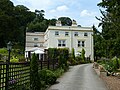
 / 52.98761; -1.44962 (Coxbench Hall and stable blocks)
Coxbench Hall (geograph 5438488).jpg
Early 18th centuryA house that has been altered and extended and later used for other purposes, it is in painted and rendered brick and sandstone, with floor bands, a moulded cornice, coped parapets, and hipped Welsh slate roofs. There are three storeys, a square plan, a two-storey extension at the northwest, and an L-shaped range of stables to the north. On the east front is a Doric porch with an iron balcony, and a round-headed doorway with a double keystone and a traceried fanlight. Most of the windows are sashes, or casements simulating sashes, and in the garden front is a bow window. In the stable block is a segmental arch with an initialled and dated keystone, and a water trough similarly inscribed. [2] [4] II
Holbrook Hall
52°59′51″N1°27′37″W / 52.99752°N 1.46036°W / 52.99752; -1.46036 (Holbrook Hall)
Early 18th centuryThe house, with an attached earlier cottage, has been extended and used for other purposes. The buildings are in sandstone, and the house has a plinth, rusticated quoins, a floor band, a moulded eaves cornice, and a hipped tile roof. There are two storeys and attics, and a front of five bays, flanked by two-bay extensions. On the garden front, semicircular steps lead to a doorway with a moulded segmental pediment, and the windows are sashes, the window above the doorway with a keystone and a moulded segmental pediment. In the roof are two gabled dormers. The extension to the south contains bay windows with balustraded parapets, and the cottage has a three-light mullioned window and casement windows. [5] [6] II*
Farm buildings, Highfield Farm
53°00′04″N1°27′27″W / 53.00103°N 1.45763°W / 53.00103; -1.45763 (Farm buildings, Highfield Farm)
Mid 18th centuryThe farm buildings are in sandstone with tile roofs, two storeys and an irregular plan. They contain doorways, windows, a hayloft door, louvred vents, and attached to the north range, is a series of stone troughs. [7] II
Rachdale Lodge
52°59′28″N1°27′37″W / 52.99102°N 1.46041°W / 52.99102; -1.46041 (Rachdale Lodge)
Mid 18th centuryThe house, which was later altered and extended, is in sandstone, and has a tile roof with coped gables and plain kneelers. There are two storeys and attics, and a front of three bays. On the front is a blocked doorway with a quoined surround, and to its left is a gabled porch. Most of the windows are mullioned, in the right two bays are gabled dormers, and the left bay contains a gabled half-dormer. [8] II
Workshop behind 18 and 20 Town Street
53°00′02″N1°27′31″W / 53.00056°N 1.45853°W / 53.00056; -1.45853 (Workshop behind 18 and 20 Town Street)
18th centuryAn outbuilding with a former stocking frame knitter's workshop above, later used for other purposes, the ground floor is in sandstone, the upper floor in red brick, and it has a tile roof. There are two storeys and two bays. In the ground floor are two doorways and a lean-to. The upper floor contains two three-light wide casement windows on the east side, and similar fixed windows on the west side. There is a flight of stone steps up to a first floor door on the north gable wall. [2] [9] II
St Michael's Church
52°59′53″N1°27′33″W / 52.99802°N 1.45929°W
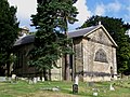
 / 52.99802; -1.45929 (St Michael's Church)
Holbrook - St Michaels Church (geograph 2795983).jpg
1761The church was largely rebuilt in 1841, restored in 1887, and in 1907–08 the chancel and porch were added. The church is built in sandstone, with a slate roof and angle pilasters. It consists of a nave, a south aisle, a north porch, and a chancel with a north vestry. At the west end are three round-arched windows, over which is an open pediment and a pedimented bellcote. On the north side of the church are windows with pointed beads and Y-tracery, at the east end is a large Diocletian window, and an open pediment above containing a clock face, and the windows on the south front have round-arched heads. [5] [10] II
Nether Cottage and outbuildings
52°59′58″N1°27′23″W / 52.99944°N 1.45633°W / 52.99944; -1.45633 (Nether Cottage and outbuildings)
Late 18th centuryThe farmhouse and outbuildings are in sandstone with slate roofs. The house has two storeys and three bays, and the outbuilding to the south has one storey and two bays. On the front of the house is a central latticed porch and a doorway with a quoined surround, and the windows are mullioned. In the outbuilding are two doorways with large lintels, and a casement window. [11] II
Outbuildings and gingang, Birchwood Farm
52°59′09″N1°27′14″W / 52.98593°N 1.45392°W / 52.98593; -1.45392 (Outbuildings and gingang, Birchwood Farm)
Early 19th centuryThe barn, stables, cowsheds, and gin gang are in sandstone, the main range has a slate roof, the gin gang has a tile roof, and the cowsheds have corrugated iron roofs. The main range has four bays, and is in one and two storeys, and the other buildings have a single storey. In the main range are stable doors, windows, and a blocked segmental arch, in the cowsheds is a lunette, and the gin gang has large doors to the angled walls. [12] II
Oakdene Cottage
52°59′54″N1°27′32″W / 52.99825°N 1.45885°W / 52.99825; -1.45885 (Oakdene Cottage)
Early 19th centuryA sandstone cottage with a tile roof, two storeys and two bays. In the centre is a gabled porch, to its right is a two-light casement window, to the left is a small square window, and in the upper floor are two horizontal-sliding sash windows. [13] II
Stables, Holbrook Hall
52°59′52″N1°27′38″W / 52.99789°N 1.46063°W / 52.99789; -1.46063 (Stables, Holbrook Hall)
Early 19th centuryThe stable block and coach house, later converted for residential use, are in sandstone, partly roughcast, with a slate roof and overhanging eaves. There are two storeys and five bays. The middle bay contains a segmental-headed arch with quoined jambs and a traceried fanlight. In the outer bays are windows with pointed heads. [5] [14] II
Workshop behind 10 Town Street
53°00′00″N1°27′33″W / 52.99997°N 1.45907°W / 52.99997; -1.45907 (Workshop behind 10 Town Street)
Early 19th centuryThe former stocking frame knitter's workshop, later used for other purposes, is in red brick with a tile roof. There are two storeys and two bays. In the ground floor are inserted double doors and a segmental-headed doorway, and the upper floor contains two wide three-light casement windows. On the south gable end is a flight of external stone steps. [2] [15] II
Walls, gates and war memorial,
St Michael's Church
52°59′54″N1°27′33″W / 52.99841°N 1.45927°W / 52.99841; -1.45927 (Walls, gates and war memorial, St Michael's Church)
c. 1841To the east and west of the churchyard are curving gritstone walls with rounded copings, containing a pair of wrought iron gates over which a scrolled overthrow with a fleur-de-lys finial and a lantern arch. To the right, dating from about 1920, is a granite war memorial in the form of a Celtic cross. On its head is carved interlace decoration, on the sloping base are inscribed the names of those lost in the First World War, and attached to the wall is a plaque with more names. [16] II
Brook House
53°00′08″N1°27′46″W / 53.00217°N 1.46287°W / 53.00217; -1.46287 (Brook House)
1899A convalescent home, later used for other purposes, it is in gritstone with applied half-timbering and a Welsh slate roof. There are two storeys, a T-shaped plan, and a symmetrical front of nine bays, the outer bays projecting as gabled cross-wings, and the middle bay containing a porch, and rising to a clock tower. The porch has a segmental arch and a hood mould, over which is a parapet and an inscribed gablet. Above this is a window with pilasters, and a carved panel. The clock tower is roughcast and has a clerestory and a pyramidal roof with a weathervane. Between the entrance and the outer bays is an arcade with lean-to roofs on moulded columns, and the gables in the outer bays have applied half-timbering and bargeboards. All the windows are mullioned and transomed. [17] [18] II

Related Research Articles

Dronfield is a civil parish in the North East Derbyshire district of Derbyshire, England. The parish contains 44 listed buildings that are recorded in the National Heritage List for England. Of these, one is listed at Grade I, the highest of the three grades, four are at Grade II*, the middle grade, and the others are at Grade II, the lowest grade. The parish contains the town of Dronfield, the district of Dronfield Woodhouse, the village of Coal Aston, and the surrounding area. Most of the listed buildings are houses, cottages and associated structures, farmhouses and farm buildings. The other listed buildings include churches, a churchyard cross, public houses, a former school, a milestone, a monument, and a bridge.

Ashover is a civil parish in the North East Derbyshire district of Derbyshire, England. The parish contains 83 listed buildings that are recorded in the National Heritage List for England. Of these, one is listed at Grade I, the highest of the three grades, and the others are at Grade II, the lowest grade. The parish is almost entirely rural, and contains the village of Ashover and smaller settlements, including Milltown and Ashover Hay. Most of the listed buildings are farmhouses and farmbuildings, houses, cottages, and associated structures. The other listed buildings include a church and items in the churchyard, chapels, public houses, a footbridge and a road bridge, a former watermill and a windmill, a pinfold, the chimney of a former engine house, a former school, and a telephone kiosk.

Aston is a civil parish in the High Peak district of Derbyshire, England. The parish contains three listed buildings that are recorded in the National Heritage List for England. All the listed buildings are designated at Grade II, the lowest of the three grades, which is applied to "buildings of national importance and special interest". The parish contains the village of Aston, and is otherwise rural. The listed buildings consist of a house, a farmhouse and an outbuilding combined into a house, and a milepost.

Ballidon is a civil parish in the Derbyshire Dales district of Derbyshire, England. The parish contains 15 listed buildings that are recorded in the National Heritage List for England. All the listed buildings are designated at Grade II, the lowest of the three grades, which is applied to "buildings of national importance and special interest". The parish contains the villages of Ballidon and Pikehall, and Ballidon Quarry, and is otherwise entirely rural. Most of the listed buildings are farmhouses and farm buildings, two of which has been converted for other uses by the quarry. The other listed buildings are a church, a milestone, a lime kiln, and an embankment and bridge, originally carrying a railway, and later part of the High Peak Trail.

Beeley is a civil parish in the Derbyshire Dales district of Derbyshire, England. The parish contains 20 listed buildings that are recorded in the National Heritage List for England. Of these, three are listed at Grade II*, the middle of the three grades, and the others are at Grade II, the lowest grade. The parish contains the village of Beeley and the surrounding countryside and moorland, mainly to the east of the village. Most of the listed buildings are houses, cottages, and associated structures. The other listed buildings include a church, a public house, a guide post and guide stone, a farmhouse, a converted barn, a former school, and a former vicarage.

Bonsall is a civil parish in the Derbyshire Dales district of Derbyshire, England. The parish contains 13 listed buildings that are recorded in the National Heritage List for England. Of these, two are listed at Grade II*, the middle of the three grades, and the others are at Grade II, the lowest grade. The parish contains the village of Bonsall and the surrounding area. The listed buildings consist of houses, cottages and associated structures, a farmhouse and an outbuilding, a market cross, two churches, a public house, a sawmill converted for residential use, and a telephone kiosk.

Brailsford is a civil parish in the Derbyshire Dales district of Derbyshire, England. The parish contains 35 listed buildings that are recorded in the National Heritage List for England. Of these, one is listed at Grade I, the highest of the three grades, and the others are at Grade II, the lowest grade. The parish contains the village of Brailsford and the hamlet of Ednaston, and the surrounding countryside. Most of the listed buildings are houses, cottages and associated structures, farmhouses and farm buildings. The other listed buildings include a church, a churchyard cross, a watermill, two boundary posts, two mileposts, a bridge, a school, and a well.

Bretby is a civil parish in the South Derbyshire district of Derbyshire, England. The parish contains 13 listed buildings that are recorded in the National Heritage List for England. Of these, two are listed at Grade II*, the middle of the three grades, and the others are at Grade II, the lowest grade. The parish contains the village of Bretby and the surrounding countryside. The listed buildings include houses, cottages and associated structures, a farmhouse and farm buildings, a church, a former school, a former watermill, a bottle kiln and factory, a war memorial and village pump, and a telephone kiosk.

Charlesworth is a civil parish in the High Peak district of Derbyshire, England. The parish contains 15 listed buildings that are recorded in the National Heritage List for England. All the listed buildings are designated at Grade II, the lowest of the three grades, which is applied to "buildings of national importance and special interest". The parish contains the village of Charlesworth and the surrounding countryside. Most of the listed buildings are houses and cottages, farmhouses and farm buildings. The other listed buildings are a bridge, a church, a chapel and its associated walls, and a war memorial.

Crich is a civil parish in the Amber Valley district of Derbyshire, England. The parish contains 52 listed buildings that are recorded in the National Heritage List for England. Of these, one is listed at Grade I, the highest of the three grades, one is at Grade II*, the middle grade, and the others are at Grade II, the lowest grade. The parish contains the villages of Crich, Fritchley, Whatstandwell, and Wheatcroft, and the surrounding countryside. Most of the listed buildings are houses, cottages and associated structures, farmhouses and farm buildings. In the parish is the National Tramway Museum, and a number of structures that have been moved from other sites to the museum are listed. The other listed buildings include churches and chapels, a bridge over the Cromford Canal and a road bridge over the River Derwent, public houses, buildings associated with tramways, a milepost, a village cross, a memorial tower, and a village telephone kiosk.

Dethick, Lea and Holloway is a civil parish in the Amber Valley district of Derbyshire, England. The parish contains 36 listed buildings that are recorded in the National Heritage List for England. Of these, five are listed at Grade II*, the middle of the three grades, and the others are at Grade II, the lowest grade. The parish contains the villages of Dethick, Lea, and Holloway, and the surrounding area. Most of the listed buildings are country houses, smaller houses, cottages, and associated structures. The other listed buildings include churches and chapels, a public house, farmhouses and farm buildings, and a bridge.

Eckington is a civil parish in the North East Derbyshire district of Derbyshire, England. The parish contains 81 listed buildings that are recorded in the National Heritage List for England. Of these, two are listed at Grade I, the highest of the three grades, two are at Grade II*, the middle grade, and the others are at Grade II, the lowest grade. The parish contains the town of Eckington, the villages of Renishaw, Ridgeway, and Spinkhill, the hamlet of Birley Hay, and the surrounding countryside. The major building in the parish is the country house, Renishaw Hall, which is listed, together with associated structures and items in its grounds. Most of the other listed buildings are houses, cottages and associated structures, farmhouses and farm buildings. The rest of the listed buildings include churches, chapels and associated items, a former Sunday school, a former toll house, a public house, and two bridges.

Elton is a civil parish in the Derbyshire Dales district of Derbyshire, England. The parish contains 20 listed buildings that are recorded in the National Heritage List for England. All the listed buildings are designated at Grade II, the lowest of the three grades, which is applied to "buildings of national importance and special interest". The parish contains the village of Elton and the surrounding countryside. Most of the listed buildings are houses, cottages and associated structures, farmhouses and farm buildings. The other listed buildings consist of a church, and a public house and its associated stables.

Elvaston is a civil parish in the South Derbyshire district of Derbyshire, England. The parish contains 28 listed buildings that are recorded in the National Heritage List for England. Of these, one is listed at Grade I, the highest of the three grades, one is at Grade II*, the middle grade, and the others are at Grade II, the lowest grade. The parish contains the village of Elvaston and the surrounding area, including the country house Elvaston Castle, which is listed, together with associated structures and buildings in its grounds. The other listed buildings are houses and cottages, a church and associated structures, two mileposts, a former school and schoolmaster's house, and a war memorial.

Eyam is a civil parish in the Derbyshire Dales district of Derbyshire, England. The parish contains 55 listed buildings that are recorded in the National Heritage List for England. Of these, one is listed at Grade I, the highest of the three grades, two are at Grade II*, the middle grade, and the others are at Grade II, the lowest grade. The parish contains the village of Eyam and the surrounding countryside. The history of the village is notable because when the plague broke out in 1666, the village went into voluntary quarantine to prevent the disease from spreading outside. Some of the listed buildings are associated with this event, including cottages occupied by the victims of the disease, and their gravestones. Most of the other listed buildings are houses, cottages and farmhouses and associated structures. The other listed buildings include a church, a cross and tombs in the churchyard, the rectory, a well head, water troughs, a set of stocks, and the former engine house to a lead mine,

Grindleford is a civil parish in the Derbyshire Dales district of Derbyshire, England. The parish contains 26 listed buildings that are recorded in the National Heritage List for England. Of these, one is listed at Grade I, the highest of the three grades, one is at Grade II*, the middle grade, and the others are at Grade II, the lowest grade. The parish contains the village of Grindleford and the surrounding countryside. Most of the listed buildings are houses, cottages and farmhouses and associated structures. The other listed buildings include a former gatehouse converted into a chapel, two bridges, a milestone and a milepost, a former cotton mill, a former toll house, and another chapel.

Hartington Town Quarter is a civil parish in the Derbyshire Dales district of Derbyshire, England. The parish contains 39 listed buildings that are recorded in the National Heritage List for England. Of these, one is listed at Grade II*, the middle of the three grades, and the others are at Grade II, the lowest grade. The parish contains the village of Hartington and the surrounding countryside. Most of the listed buildings are houses, cottages, farmhouses, and associated structures. The other listed buildings include a church, hotels and public houses, a bridge, two mileposts, and a war memorial.

Hathersage is a civil parish in the Derbyshire Dales district of Derbyshire, England. The parish contains 54 listed buildings that are recorded in the National Heritage List for England. Of these, one is listed at Grade I, the highest of the three grades, three are at Grade II*, the middle grade, and the others are at Grade II, the lowest grade. The parish, which is almost entirely rural, contains the village of Hathersage and the surrounding countryside. Most of the listed buildings are farmhouses and farm buildings, houses, cottages, and associated structures. The other listed buildings include two churches, a cross shaft in a churchyard, a presbytery and a vicarage, two bridges, former mills, a milepost, a former toll house, a railway viaduct, and a lamp column.

Fairfield is a district in the town of Buxton in the High Peak district of Derbyshire, England. The district of Fairfield contains nine listed buildings that are recorded in the National Heritage List for England. All the listed buildings are designated at Grade II, the lowest of the three grades, which is applied to "buildings of national importance and special interest". Apart from a church, all the listed buildings are houses, farmhouses or cottages.

Hognaston is a civil parish in the Derbyshire Dales district of Derbyshire, England. The parish contains nine listed buildings that are recorded in the National Heritage List for England. Of these, one listed at Grade II*, the middle of the three grades, and the others are at Grade II, the lowest grade. The parish contains the village of Hognaston and the surrounding area. The listed buildings consist of houses, cottages, farmhouses, a church, and a telephone kiosk.

References

Citations

Sources