Listed buildings in Widnes

Last updated

Tower Building, originally the office of Hutchinson & Co, now part of the Catalyst Science Discovery Centre Catalyst 1.jpg
Tower Building, originally the office of Hutchinson & Co, now part of the Catalyst Science Discovery Centre

Widnes is an industrial town in the Borough of Halton, Cheshire, England, on the north bank of the River Mersey where it narrows at Runcorn Gap. The town contains 24 buildings that are recorded in the National Heritage List for England as designated listed buildings. Of these, 5 are classified at Grade II*, and the rest are at Grade II; Widnes has no Grade I listed buildings. In the United Kingdom, the term "listed building" refers to a building or other structure officially designated as being of special architectural, historical, or cultural significance. Listed buildings are categorised in three grades: Grade I consists of buildings of outstanding architectural or historical interest; Grade II* includes particularly significant buildings of more than local interest; Grade II consists of buildings of special architectural or historical interest. Buildings in England are listed by the Secretary of State for Culture, Media and Sport on recommendations provided by English Heritage, which also determines the grading. [1]

Contents

Before 1847, the area now occupied by the town of Widnes consisted of the hamlets of Farnworth, Cronton, Appleton, and Upton; a few scattered houses; and areas of mostly marshy farmland. [2] In 1833 a canal and a railway reached the area; the Sankey Canal was extended to a point on the River Mersey to the east of Runcorn Gap and the St Helens and Runcorn Gap Railway established a terminus adjacent to the canal. Widnes Dock, the world's first railway dock, was established at the new terminal, [3] and in 1847 John Hutchinson established the first chemical factory nearby. [2] During the second half of the 19th century, more chemical factories were built and the town grew, absorbing the previously separated hamlets. [4] The town became overcrowded [5] and highly polluted with smoke, chemical fumes, and waste. [6]

The town's listed buildings reflect its history. The oldest, St Luke's Church in the former village of Farnworth, dates from the 12th century. Also built before 1847 are three houses, a bridewell adjacent to St Luke's Church, and the lock at the terminus of the Sankey Canal. The buildings from after 1847—four churches and the cemetery chapels, one public building (the town hall), two railway stations, two bridges crossing the River Mersey, and the former power house of the now-demolished transporter bridge—largely reflect the growing population of the town and its increasing transport links. The Tower Building, formerly an office and now a museum, and a sewer vent, relate to the chemical industry. The latest structures to be listed are a war memorial in Victoria Park and the former Widnes Corporation bus depot. Other than the bridges and the lock, the building materials used are brick, local red sandstone, and terracotta.

Key

GradeCriteria [7]
II*Particularly important buildings of more than special interest
IIBuildings of national importance and special interest
Name and locationPhotographGradeDateDescription
St Luke's Church, Farnworth
53°23′04″N2°43′38″W / 53.3844°N 2.7273°W / 53.3844; -2.7273 (St Luke's Church, Farnworth)
Widnes Farnworth St Luke 2.jpg II*12th century with later additionsSt Luke's is a parish church constructed in red sandstone dating from the late 12th century. Its tower was added in the 14th century. There were later additions and restorations, the final restoration being in 189495. The plan consists of a west tower, a five-bay nave with north and south aisles, a chancel, and north and south porches. At the east end of the north aisle is the Bold Chapel, which contains many family monuments, and the transept is known as the Cuerdley Chapel. [8] [9] [10]
Runcorn Railway Bridge
53°20′48″N2°44′18″W / 53.3468°N 2.7383°W / 53.3468; -2.7383 (Runcorn Railway Bridge)
Runcorn Railway Bridge.jpg II*1864–68Spanning the River Mersey to provide a more direct rail connection between London and Liverpool, the bridge is constructed of three wrought iron girders carried on four sandstone piers. It is approached on each side by viaducts. The structure was designed by William Baker and now carries the Liverpool branch of the West Coast Main Line. [11] [12] [13] [14]
St Michael's Church, Ditton
53°21′45″N2°45′40″W / 53.3625°N 2.7610°W / 53.3625; -2.7610 (St Michael's Church, Ditton)
Widnes St Michael.jpg
II*1876–79St Michael's is a Catholic church built for a Jesuit community who had been expelled from Germany in 1872. It is constructed in red sandstone ashlar and has a cruciform plan. At the west end is a tall tower with a saddleback roof. [15] [16] [17]
St Mary's Church, West Bank
53°20′56″N2°43′58″W / 53.3488°N 2.7329°W / 53.3488; -2.7329 (St Mary's Church)
Widnes St Mary's.jpg
II*1908–10St Mary's parish church was built to replace an earlier church nearby which had been damaged by subsidence. It is constructed in red sandstone in Perpendicular style. It has a nave, aisles, transepts, chancel and a tower at the west end. [18] [19] [20]
Former power house of the Widnes-Runcorn transporter bridge
53°20′52″N2°44′09″W / 53.34774°N 2.73595°W / 53.34774; -2.73595 (Former power house)
Widnes transporter bridge power house 1.jpg II*1901This is a small red sandstone rectangular building in three storeys which originally contained the power house to drive the transporter bridge. It has been converted into use as an electrical sub-station. [21] [22]
Norland's House
53°23′39″N2°44′35″W / 53.39415°N 2.74312°W / 53.39415; -2.74312 (Norland's House)
Widnes Norlands House.jpg IIEarly 18th centuryNorland's House is a farmhouse dating from the early 18th century with later alterations and additions. The house is built in brick on a stone plinth. It has two storeys and has been painted white. At the corners are rusticated quoins which have been painted black. [23]
The Hollies
53°22′52″N2°43′43″W / 53.38107°N 2.72874°W / 53.38107; -2.72874 (The Hollies)
Widnes The Hollies.jpg IILate 18th centuryThe Hollies is a brick house with two storeys which was built in the 18th century. At the sides of its doorway are Doric fluted columns and over it are a moulded frieze and a fanlight. From 1867 to 1873 it was the home of Ludwig Mond. [24]
103, 105, 107 and 109 Highfield Road
53°22′26″N2°44′03″W / 53.3739°N 2.7341°W / 53.3739; -2.7341 (Nos. 103, 105, 107 and 109 Highfield Road)
Widnes Highfield Rd.jpg IIEarly 19th centuryThis is a terrace of four brick houses with slate roofs which were built in the early 19th century. They have two storeys with a string course between them. [25]
Farnworth bridewell
53°23′04″N2°43′37″W / 53.38436°N 2.72699°W / 53.38436; -2.72699 (Bridewell)
Farnworth Bridewell.jpg II1827This was originally a bridewell situated adjacent to St Luke's churchyard. It is a plain rectangular building in red sandstone with a slate roof. [26]
Mersey Lock, Sankey Canal
53°21′09″N2°43′54″W / 53.3525°N 2.7317°W / 53.3525; -2.7317 (Mersey Lock)
Mersey Lock.jpg II1833The lock is at Spike Island, the terminus of the Sankey Canal where it joins the River Mersey. There is a difference of 12 feet (4 m) between the water level in the canal and the river. [27]
St Bede's Church
53°22′16″N2°43′51″W / 53.3711°N 2.7308°W / 53.3711; -2.7308 (St Bede's Church)
Widnes St Bede.jpg II1847St Bede's is a Catholic church built in red sandstone. The west tower is broad and has angle buttresses and gargoyles. The plan of the church consists of a nave with aisles, and a chancel with a tripartite east end. [28] [29]
Tower Building, now part of Catalyst Science Discovery Centre
53°21′07″N2°44′01″W / 53.35184°N 2.73364°W / 53.35184; -2.73364 (Tower Building)
Catalyst 1.jpg IIc. 1860Tower Building was constructed for the chemical firm of Hutchinson & Co and was later used by Gossage's. In 1989 it was converted into a museum; a glass-surrounded observation deck was built on the roof and a glass external lift was added to the east. [30] [31] [32]
St Marie's Church
53°21′45″N2°43′38″W / 53.3624°N 2.7271°W / 53.3624; -2.7271 (St Marie's Church)
Widnes St Marie 1.jpg II1864This was a Catholic church which was designed by E. W. Pugin and has been little altered since. It is built in red brick with sandstone dressings. Its plan consists of a nave and apse with lean-to aisles. The church became redundant in 2006 and was listed the same year. [33] [34]
Hough Green railway station
53°22′21″N2°46′30″W / 53.37245°N 2.77507°W / 53.37245; -2.77507 (Hough Green railway station)
Widnes Hough Green Station.jpg II1872The station was built in brick for the Cheshire Lines Committee. It has an H-shaped plan with gables at each end and a canopy between. [35] [36]
Widnes railway station
53°22′43″N2°44′01″W / 53.37856°N 2.73361°W / 53.37856; -2.73361 (Widnes railway station)
Widnes railway station.jpg II1872Widnes station was built in brick for the Cheshire Lines Committee. It has an H-shaped plan with gables at each end and a canopy between. It was originally called Farnworth station. [37] [38] [39]
Former town hall
53°21′43″N2°43′55″W / 53.36195°N 2.73183°W / 53.36195; -2.73183 (Former town hall)
Widnes Town Hall 1.jpg II1885The former Widnes Town Hall is built in brick with terra cotta dressings. It is a symmetrical building in nine bays with an ornate central bay and Dutch gables over the outer bays. [33] [40]
Sewer vent
53°22′21″N2°43′07″W / 53.372410°N 2.718569°W / 53.372410; -2.718569 (Sewer vent)
Widnes Sewer tower.jpg
IIc. 1893This chimney-like structure is a sewer ventilation shaft, built in decorated brickwork and approximately 30 feet (9 m) high. It is the last survivor of a system of seven vents whose purpose was to remove the effluent from chemical manufacture. [41] [42]
Cemetery chapels
53°22′51″N2°44′09″W / 53.3809°N 2.7358°W / 53.3809; -2.7358 (Cemetery chapels)
Cemetery chapels.jpg II1897This is a pair of joined gabled chapels that are built in red sandstone. Between the chapels is a tower with an octagonal steeple. Part of the structure has been converted into a crematorium with the steeple used as a chimney. [43]
Wayside pulpit, St Mary's Church
53°20′54″N2°43′59″W / 53.348433°N 2.732975°W / 53.348433; -2.732975 (Wayside pulpit)
Widnes Wayside Pulpit.jpg IIc. 1910This sandstone structure is a pulpit which forms part of the boundary wall of the churchyard of St Mary's Church. It incorporates a religious text which reads, "Go out into the highways and compel them to come in that my house may be filled". [44]
War memorial,
Victoria Park
53°22′28″N2°43′49″W / 53.37454°N 2.73039°W / 53.37454; -2.73039 (War memorial)
Widnes war memorial.jpg II1921Listed in 2007, the memorial is built in York and Portland stone. It comprises an obelisk surmounted by a flaming urn which stands on a plinth on a platform. The sculptor was Herbert Tyson Smith. [45] [46] [47]
Former Widnes Corporation Bus Depot
53°21′44″N2°44′13″W / 53.36214°N 2.73695°W / 53.36214; -2.73695 (Bus Depot)
Former Widnes Corporation Bus Depot, Moor Lane, Widnes (NHLE Code 1472426) (September 2021) (2).JPG II1923The bus depot was built for Widnes Corporation, and is in orange brick with decoration in orange terracotta, and roofs of steel with sheeting in corrugated metal, asbestos and plastic. It consists of a long rectangular building with a full-height covered garage to the rear, and a lower office and a workshop range. On the front are three vehicle entrances, each under a triangular pediment containing a triangular panel, two with finials. Between them are two-storey office buildings containing windows with terracotta surrounds. At the rear of the yards is a workshop range. [48]
Kingsway Health Centre
53°21′48″N2°43′59″W / 53.3633°N 2.7330°W / 53.3633; -2.7330 (Kingsway Health Centre)
Widnes Health Centre.jpg II1938–39This a rare example of a 1930s comprehensive health centre outside London. It is designed in Moderne style and incorporates Art Deco elements. It was listed in 2009, and the associated walls, gates and railings are included in the listing. [49]
Silver Jubilee Bridge
53°20′47″N2°44′16″W / 53.3463°N 2.7379°W / 53.3463; -2.7379 (Silver Jubilee Bridge)
Silver Jubilee Bridge.jpg II1956–61This road bridge crosses the River Mersey and links Runcorn with Widnes, replacing the former Widnes–Runcorn Transporter Bridge. It is a through arch bridge which carries a four-lane carriageway and a cantilevered footway to the east. Its span is 1,082 feet (330 m) and its total length is 1,628 feet (496 m). [50] [51] [52]
Former Church of St Pius X and attached campanile
53°22′52″N2°43′55″W / 53.3811°N 2.7319°W / 53.3811; -2.7319 (Former Church of St Pius X and attached campanile)
St Pius X Roman Catholic Church, Widnes (geograph 3423658).jpg
II1960The former Roman Catholic church and the campanile are built in yellow brick with dressings in stone and concrete, and the church has a tile roof. The church has a rectangular plan and consists of a nave and a chancel, with the campanile attached to the southwest. Along the sides of the church are tall pointed windows in bays divided by buttresses. The campanile is 21 metres (69 ft) tall, it has a square plan, and contains tall, narrow bell openings. [53] [54]

Related Research Articles

<span class="mw-page-title-main">Runcorn</span> Town in England

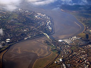
Runcorn is an industrial town and cargo port in the Borough of Halton, Cheshire, England. Its population in 2021 was 62,100. Runcorn is on the southern bank of the River Mersey, where the estuary narrows to form the Runcorn Gap.

<span class="mw-page-title-main">Borough of Halton</span> Unitary authority area in Cheshire, England

Halton is a local government district with borough status in the ceremonial county of Cheshire, North West England. The borough was created in 1974 and contains the towns of Runcorn and Widnes and the civil parishes of Daresbury, Hale, Halebank, Moore, Preston Brook, and Sandymoor. Since 1998, Halton Borough Council has been a unitary authority, being a district council which also performs the functions of a county council. Since 2014, it has been a member of the Liverpool City Region Combined Authority.

<span class="mw-page-title-main">Silver Jubilee Bridge</span> Bridge in northwest England

The Silver Jubilee Bridge crosses the River Mersey and the Manchester Ship Canal at Runcorn Gap between Runcorn and Widnes in Halton, England. It is a through arch bridge with a main arch span of 361 yards. It was opened in 1961 as a replacement for the Widnes–Runcorn Transporter Bridge. In 1975–77 the carriageway was widened, after which the bridge was given its official name in honour of the Queen's Silver Jubilee. It carries the A533 road and a cantilevered footway. The bridge is recorded in the National Heritage List for England as a designated Grade II listed building. The bridge was closed to vehicles for refurbishment upon the opening of the new Mersey Gateway Bridge, but reopened as a toll bridge in February 2021.

<span class="mw-page-title-main">Widnes–Runcorn Transporter Bridge</span> Former bridge in northwest England

The Widnes–Runcorn Transporter Bridge crossed the river Mersey and Manchester Ship Canal linking the towns of Runcorn and Widnes. Completed in 1905, it was Britain's first transporter bridge and the largest of its type ever built in the world. It continued in use until 22 July 1961, when it was replaced by a through arch bridge, now known as the Silver Jubilee Bridge. The transporter bridge was then demolished.

<span class="mw-page-title-main">Runcorn Railway Bridge</span> Bridge in northwest England

The Runcorn Railway Bridge, Ethelfleda Bridge or Britannia Bridge crosses the River Mersey at Runcorn Gap between Runcorn and Widnes in Cheshire, England. It is alongside the Silver Jubilee Bridge. The bridge is recorded in the National Heritage List for England as a Grade II* Listed building.

<span class="mw-page-title-main">Widnes</span> Town in Cheshire, England

Widnes is an industrial town in the Borough of Halton, Cheshire, England, which at the 2021 census had a population of 62,400.

<span class="mw-page-title-main">St Luke's Church, Farnworth</span> Church in Cheshire, England

St Luke's Church, Farnworth, Widnes, is a church in Farnworth, which was once a separate village but is now part of the town of Widnes, Cheshire, England. The church dates back to the 12th century and contains several items of historical interest, particularly hatchments and memorials. It is recorded in the National Heritage List for England as a designated Grade II* listed building, and is an active Anglican parish church in the diocese of Liverpool, the archdeaconry of Warrington and the deanery of Widnes.

<span class="mw-page-title-main">Listed buildings in Runcorn (urban area)</span>

Runcorn is an industrial town in Halton, Cheshire, England, on the south bank of the River Mersey where it narrows at Runcorn Gap. In the town are the 61 buildings that are recorded in the National Heritage List for England as designated listed buildings in the current urban area of Runcorn, including the districts of Runcorn, Halton, Weston, Weston Point, and Norton. Two of these are classified as being in Grade I, nine in Grade II*, and 51 in Grade II.

<span class="mw-page-title-main">St Michael's Church, Ditton</span> Church in Cheshire, England

St Michael's Church is in St Michael's Road, Ditton, Widnes, Halton, Cheshire, England. It is recorded in the National Heritage List for England as a designated Grade II* listed building. It is an active Roman Catholic church.

<span class="mw-page-title-main">St Mary's Church, Widnes</span> Church in Cheshire, England

St Mary's Church is in the West Bank area of Widnes, Cheshire, England. The church is recorded in the National Heritage List for England as a designated Grade II* listed building. It is an active Anglican parish church in the diocese of Liverpool, the archdeaconry of Warrington and the deanery of Widnes. Together with the churches of St Paul, Widnes, and St Mary, Hale, it forms the South Widnes Team. It has been described as "the last great church masterpiece" created by the Lancaster architects Austin and Paley.

<span class="mw-page-title-main">St Marie's Church, Widnes</span> Church in Cheshire, England

St Marie's Church is a redundant Roman Catholic church in Lugsdale Road, Widnes, Cheshire, England. It is recorded in the National Heritage List for England as a designated Grade II listed building.

<span class="mw-page-title-main">Catalyst Science Discovery Centre</span> Museum in Widnes, Cheshire, England

The Catalyst Science Discovery Centre and Museum is a science and technology museum in Widnes, Halton, North-West England. The centre has interactive exhibits, reconstructed historical scenes, an observatory, a live-science theatre and family workshops. It is next to Spike Island, a public park, located between the River Mersey and the Sankey Canal that has woodlands, wetlands, footpaths and industrial archaeological history.

<span class="mw-page-title-main">Halton Borough Council</span>

Halton Borough Council is the local authority for Halton, a local government district with borough status in the ceremonial county of Cheshire, England. Since 1998 the council has been a unitary authority, being a district council which also performs the functions of a county council. Since 2014 the council has been a member of the Liverpool City Region Combined Authority.

<span class="mw-page-title-main">Listed buildings in Runcorn (rural area)</span>

Runcorn is an industrial town in the borough of Halton, Cheshire, England. This list contains the 27 buildings that are recorded in the National Heritage List for England as designated listed buildings in the part of the borough lying to the south of the River Mersey outside the urban area of Runcorn. The area covered includes the villages of Clifton, Daresbury, Preston Brook, Preston on the Hill, and Moore. Three of the buildings in the area are classified as Grade II*, and the others are at Grade II; there are no buildings in Grade I. In the United Kingdom, the term listed building refers to a building or other structure officially designated as being of special architectural, historical, or cultural significance. These buildings are in three grades: Grade I consists of buildings of outstanding architectural or historical interest; Grade II* includes particularly significant buildings of more than local interest; Grade II consists of buildings of special architectural or historical interest. Buildings in England are listed by the Secretary of State for Culture, Media and Sport on recommendations provided by English Heritage, which also determines the grading.

Hale is a civil parish in the borough of Halton, Cheshire, England. The parish contains 17 buildings that are recorded in the National Heritage List for England as designated listed buildings. Of these, one is listed at Grade II*, the middle grade, and the others are at Grade II, the lowest grade. The parish includes the village of Hale, and this is surrounded by agricultural land. It is on the north bank of the River Mersey and includes the promontory of Hale Head. Almost all of the listed buildings are houses and cottages in the village, the others consisting of the parish church, an ice house in the grounds of the former Hale House, and a former lighthouse on Hale Head.

<span class="mw-page-title-main">Weston, Runcorn</span> Human settlement in England

Weston or Weston Village is a settlement in the Halton district, in the ceremonial county of Cheshire, England. Formerly a separate village, it is now part of the town of Runcorn.

There are over 9,000 Grade I listed buildings and 20,000 Grade II* listed buildings in England. This page is a list of these buildings in the borough of Halton in Cheshire.

There are over 9,000 Grade I listed buildings and 20,000 Grade II* listed buildings in England. This page is a list of these buildings in the unitary authority of Warrington in Cheshire, including the town of Warrington and 18 other civil parishes.

There are over 9,000 Grade I listed buildings in England. This page is a list of these buildings in the unitary authority of Cheshire West and Chester.

St Helens is a town in the Metropolitan Borough of St Helens, Merseyside, England. The unparished area contains 67 buildings that are recorded in the National Heritage List for England as designated listed buildings. Of these, one is listed at Grade I, the highest grade, five are listed at Grade II*, the middle of the three grades, and the others are at Grade II, the lowest grade. The main town in the district is St Helens, the others being Newton-le-Willows and Earlestown. Until the Industrial Revolution, the area was largely rural. Coal mining began in the 16th century, but modern industrial development began with the construction of the Sankey Canal in the late 18th century, linking St Helens with the River Mersey. The early 19th century saw new industries, including copper smelting, production of alkali, and the manufacture of glass. Of these, the major industry was glass making, the main business being that of Pilkingtons. The first major railway line in the world, the Liverpool and Manchester Railway was built through the district, opening in 1830.

References

Citations

  1. Planning (Listed Buildings and Conservation Areas) Act 1990, HM Government, retrieved 19 November 2018
  2. 1 2 Hardie 1950 , pp. 1–3
  3. Diggle 1961 , pp. 17–19
  4. Morris 2005 , p. 171
  5. Morris 2005 , pp. 172–174
  6. Morris 2005 , pp. 208–209
  7. Listed Buildings, Historic England , retrieved 19 November 2018
  8. Foster 1981 , pp. 35–42
  9. Pollard & Pevsner 2006 , pp. 653–655
  10. Historic England, "Church of St Luke, Widnes (1130417)", National Heritage List for England , retrieved 23 September 2013
  11. Historic England, "Runcorn Bridge railway bridge over River Mersey (1130418)", National Heritage List for England, retrieved 23 September 2013
  12. Starkey 1990 , pp. 166–170
  13. Nickson 1887 , pp. 202–206
  14. Cowan 1990 , pp. 5–7, 10
  15. Diggle 1961 , pp. 66–67
  16. Pollard & Pevsner 2006 , p. 657
  17. Historic England, "Church of St Michael, Ditton (1325926)", National Heritage List for England, retrieved 23 September 2013
  18. Diggle 1961 , pp. 120–121
  19. Pollard & Pevsner 2006 , pp. 648–649
  20. Historic England, "Church of St Mary, Widnes (1130420)", National Heritage List for England, retrieved 23 September 2013
  21. Thompson 2000 , pp. 12–15
  22. Historic England, "Former Transporter Bridge Power House, Widnes (1130419)", National Heritage List for England, retrieved 23 September 2013
  23. Historic England, "Norland's House, Widnes (1330352)", National Heritage List for England, retrieved 23 September 2013
  24. Historic England, "The Hollies, Widnes (1130413)", National Heritage List for England, retrieved 23 September 2013
  25. Historic England, "Nos. 103, 105, 107 & 109 Highfield Road, Widnes (1130414)", National Heritage List for England, retrieved 23 September 2013
  26. Historic England, "Bridewell adjacent to Church of St Luke, Widnes (1330353)", National Heritage List for England, retrieved 23 September 2013
  27. Historic England, "Mersey Lock St Helens Canal, Widnes (1330354)", National Heritage List for England, retrieved 23 September 2013
  28. Pollard & Pevsner 2006 , pp. 652–653
  29. Historic England, "Church of St Bede, Widnes (1130411)", National Heritage List for England, retrieved 23 September 2013
  30. Hardie 1950 , p. 56
  31. Pollard & Pevsner 2006 , p. 650
  32. Historic England, "Gossage's Tower, Widnes (1130415)", National Heritage List for England, retrieved 23 September 2013
  33. 1 2 Pollard & Pevsner 2006 , p. 651
  34. Historic England, "Roman Catholic Church of St Marie, Widnes (1391829)", National Heritage List for England, retrieved 23 September 2013
  35. Pollard & Pevsner 2006 , pp. 656, 658
  36. Historic England, "Hough Green Railway Station (1330351)", National Heritage List for England, retrieved 23 September 2013
  37. Pollard & Pevsner 2006 , p. 656
  38. Dyckhoff 1999 , p. 74
  39. Historic England, "Widnes North Railway Station (1106340)", National Heritage List for England, retrieved 23 September 2013
  40. Historic England, "Widnes Town Hall (1330355)", National Heritage List for England, retrieved 23 September 2013
  41. Pollard & Pevsner 2006 , p. 652
  42. Historic England, "Brick sewer vent, Widnes (1130416)", National Heritage List for England, retrieved 23 September 2013
  43. Historic England, "Pair of Cemetery Chapels, Widnes (1130412)", National Heritage List for England, retrieved 23 September 2013
  44. Historic England, "Wayside pulpit to Church of St Mary, Widnes (1325946)", National Heritage List for England, retrieved 23 September 2013
  45. Pollard & Pevsner 2006 , p. 653
  46. Historic England, "War memorial, Victoria Park, Widnes (1392210)", National Heritage List for England, retrieved 23 September 2013
  47. Morris & Roberts 2012 , pp. 250–251
  48. Historic England, "Former Widnes Corporation Bus Depot, Widnes (1472426)", National Heritage List for England, retrieved 4 December 2020
  49. Historic England, "Kingsway Health Centre and associated walls, gates and railings, Widnes (1393291)", National Heritage List for England, retrieved 23 September 2013
  50. Historic England, "Runcorn-Widnes Road Bridge (1130421)", National Heritage List for England, retrieved 23 September 2013
  51. Hartwell et al. 2011 , p. 562
  52. Starkey 1990 , p. 222
  53. Historic England, "Former Church of St Pius X and attached campanile (1455848)", National Heritage List for England, retrieved 23 November 2018
  54. Pollard & Pevsner 2006 , p. 655

Sources

  • Cowan, C. A. (1990), Runcorn Railway Bridge, Crossing the Runcorn Gap, vol. 3, Halton: Halton Borough Council
  • Diggle, Rev. G. E. (1961), A History of Widnes, Corporation of Widnes, OCLC   450270
  • Dyckhoff, Nigel (1999), Portrait of the Cheshire Lines Committee, Shepperton: Ian Allan, ISBN   978-0-711-02521-9
  • Foster, Alan (1981), A History of Farnworth Church, its Parish and Village, Widnes, OCLC   48671380 {{citation}}: CS1 maint: location missing publisher (link)
  • Hardie, D. W. F. (1950), A History of the Chemical Industry in Widnes, London: Imperial Chemical Industries Limited, OCLC   7503517
  • Hartwell, Clare; Hyde, Matthew; Hubbard, Edward; Pevsner, Nikolaus (2011) [1971], Cheshire, The Buildings of England, New Haven and London: Yale University Press, ISBN   978-0-300-17043-6
  • Morris, Edward; Roberts, Emma (2012), Public Sculpture of Cheshire and Merseyside (excluding Liverpool), Public Sculpture of Britain, vol. 15, Liverpool: Liverpool University Press, ISBN   978-1-84631-492-6
  • Morris, Jean M. (2005), Into the Crucible, Countryvise Limited, ISBN   1-901231-61-5
  • Nickson, Charles (1887), History of Runcorn, London and Warrington: Mackie & Co., OCLC   5389146
  • Pollard, Richard; Pevsner, Nikolaus (2006), Lancashire: Liverpool and the South-West, The Buildings of England, New Haven and London: Yale University Press, ISBN   0-300-10910-5
  • Starkey, H. F. (1990), Old Runcorn, Halton Borough Council
  • Thompson, Dave (2000), Bridging the Mersey: A Pictorial History, Zaltbommel: European Library, ISBN   978-9-028-82640-3