Listed buildings in Wormhill

Last updated

Wormhill is a civil parish in the High Peak district of Derbyshire, England. The parish contains 26 listed buildings that are recorded in the National Heritage List for England. Of these, three are listed at Grade II*, the middle of the three grades, and the others are at Grade II, the lowest grade. The parish contains the village of Wormhill and the surrounding area. Most of the listed buildings are houses, cottages and associated structures, farmhouses and farm buildings. The other listed buildings include a church and associated structures, a village cross moved into the churchyard, a railway viaduct, and a memorial fountain.

Contents

Key

Map all coordinates using: OpenStreetMap  
Download coordinates as: KML
GradeCriteria [1]
II*Particularly important buildings of more than special interest
IIBuildings of national importance and special interest

Buildings

Name and locationPhotographDateNotesGrade
St Margaret's Church
53°15′52″N1°48′53″W / 53.26450°N 1.81477°W / 53.26450; -1.81477 (St Margaret's Church)
Wormhill Church Geograph-3475535-by-Neil-Theasby.jpg
13th centuryThe oldest part of the church is the west end and the tower, the rest being rebuilt in 1864, and the transepts added in 1904–10. The church is built in limestone with gritstone dressings, some tufa at the west end, and slate roofs. It consists of a nave, a south porch, a chancel with north and south transepts and a sanctuary, and a west tower. The tower has four stages, it is unbutressed, and has a west window and smaller windows with trefoil heads, and a helm roof. The porch is gabled and has a doorway with a pointed arch, and the east window has three lights with Decorated glazing and a hood mould. [2] [3] II*
Former village cross
53°15′52″N1°48′53″W / 53.26437°N 1.81485°W / 53.26437; -1.81485 (Former village cross)
Former Village Cross In St Margaret's Churchyard.jpg
Medieval|The village cross, now in the churchyard of St Margaret's Church, is in gritstone. It consists of the stump of a shaft on a square base, on two steps. A sundial face dated 1670 has been fitted to the top of the shaft. [4] [5] II
Old Hall Farmhouse
53°16′04″N1°49′08″W / 53.26772°N 1.81891°W / 53.26772; -1.81891 (Old Hall Farmhouse)
Old Hall Farmhouse, Wormhill.jpg
16th to 17th centuryThe farmhouse is in roughcast limestone with gritstone dressings, quoins, and a stone slate roof with coped gables and moulded kneelers. There are two storeys and an L-shaped plan, consisting of a four-bay range, and a gabled cross-wing at the west end. The doorway has a chamfered quoined surround and a rectangular fanlight, and the windows are mullioned with five lights, those in the ground floor and east gable end with hood moulds. [4] [6] II
Dakin Farmhouse
53°16′26″N1°49′23″W / 53.27385°N 1.82303°W / 53.27385; -1.82303 (Dakin Farmhouse)
1623The farmhouse is in limestone with gritstone dressings, quoins and a stone slate roof. There are two storeys and an L-shaped plan, with a main range of four bays, and a gabled cross-wing on the northeast. The windows are mullioned, some with moulded surrounds, and some with hood moulds. The doorway has a plain surround, a dated lintel, and a bracketed flat hood, and above it are two square inscribed tablets. [7] II
Wormhill Hall
53°15′48″N1°48′53″W / 53.26347°N 1.81467°W / 53.26347; -1.81467 (Wormhill Hall)
Wormhill Hall.jpg
1697A small country house in gritstone, with quoins, and a roof with moulded copings and kneelers. There are two storeys and attics, and an H-shaped plan, consisting of a seven-bay range with a parapet, flanked by two-bay gabled cross-wings. In the centre is a doorway with a moulded surround and a segmental pediment. The windows are mullioned, and have cornices connected by string courses. The rainwater heads are dated and initialled, and at the rear is a stair tower. [4] [8] II*
Range northwest of Wormhill Hall
53°15′49″N1°48′53″W / 53.26367°N 1.81467°W / 53.26367; -1.81467 (Range northwest of Wormhill Hall)
Early 18th centuryAn ancillary wing to the hall, it is in limestone with gritstone dressings, and a stone slate roof with a coped gable at the northwest end. There are two storeys and eight bays. On the front are three doorways with massive surrounds, and the windows are mullioned with two lights. [4] [9] II
Chapelsteads Farmhouse
53°15′45″N1°48′49″W / 53.26261°N 1.81374°W / 53.26261; -1.81374 (Chapelsteads Farmhouse)
Chapelsteads Farmhouse.jpg
Mid 18th centuryThe farmhouse is in roughcast stone with gritstone dressings, and a roof of stone slate and tile. There are two storeys and three bays. The windows are mullioned with added lights, and contain a mix of sashes and casements. The doorway has a plain surround. [10] II
Outbuilding south of Chapelsteads Farmhouse
53°15′44″N1°48′50″W / 53.26212°N 1.81383°W
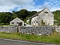
 / 53.26212; -1.81383 (Outbuilding south of Chapelsteads Farmhouse)
Outbuilding To The South Of Chapelsteads Farmhouse.jpg
Mid 18th centuryThe outbuilding is in limestone with gritstone dressings and a stone slate roof. There are two storeys and eight bays. It contains seven doorways with massive frames, one blocked with an inserted window. In the upper floor is a square opening, and the south gable contains dovecote openings with perches. [11] II
Milne House
53°15′20″N1°47′40″W / 53.25546°N 1.79434°W / 53.25546; -1.79434 (Milne House)
Mid 18th centuryThe house is in limestone with gritstone dressings, rusticated quoins and a Welsh slate roof. There are two storeys and three bays, and an added bay at the west end with a stone slate roof. The doorway has massive jambs and lintel, and a shallow bracketed canopy. The windows are mullioned and contain two sashes. [12] II
Barn northwest of Old Hall Farmhouse
53°16′05″N1°49′10″W / 53.26803°N 1.81940°W / 53.26803; -1.81940 (Barn northwest of Old Hall Farmhouse)
Barn To The North West Of Old Hall Farmhouse.jpg
Mid 18th centuryThe barn is in limestone with gritstone dressings, quoins and a tile roof. There is a T-shaped plan, with two storeys at the east end, and a single storey at the west end. The barn contains three doorways with quoined surrounds and heavy lintels, and there are two openings in the upper floor, one a taking-in door. [13] II
Cottage northeast of The Vicarage
53°15′54″N1°48′53″W / 53.26504°N 1.81466°W / 53.26504; -1.81466 (Cottage northeast of The Vicarage)
Mid 18th centuryThe cottage is in limestone with gritstone dressings, and has a roof of Welsh slate and stone slate with a coped southeast gable and moulded kneeler. There are two storeys and an L-shaped plan. Most of the windows are mullioned, and there are two fire windows. [14] II
Gate piers and walls, Wormhill Hall
53°15′48″N1°48′55″W / 53.26330°N 1.81529°W / 53.26330; -1.81529 (Gate piers and walls, Wormhill Hall)
Mid 18th centuryThe gate piers flanking the entrance to the grounds are square, in gritstone, with projecting moulded caps and ball finials, and between them are wooden gates. Outside them are low curving walls with saddleback copings, linking with the boundary walls carrying timber fencing. These walls contain smaller piers, and two doorways with quoined surrounds. [15] II
Outer gate piers, Wormhill Hall
53°15′46″N1°49′00″W / 53.26289°N 1.81653°W / 53.26289; -1.81653 (Outer gate piers, Wormhill Hall)
Outer Gate Piers At Wormhill Hall.jpg
Mid 18th centuryThe gate piers are square, in gritstone, and have moulded drips, projecting moulded caps, and ball finials. Between them are iron gates with spear-headed railings. [16] II
Stables and cottage northwest of Wormhill Hall
53°15′50″N1°48′55″W / 53.26380°N 1.81541°W / 53.26380; -1.81541 (Stables and cottage northwest of Wormhill Hall)
Mid 18th centuryThe building is in limestone with gritstone dressings, quoins, and a stone slate roof with coped gables and moulded kneelers. There are two storeys, and it contains an archway with a quoined surround and a narrow arched head. This is flanked by blocked doorways, and in the upper floor are two rectangular openings. The cottage is at the north end, and there is an extension to the west. [17] II
Knotlow Farmhouse and outbuilding
53°15′56″N1°48′59″W / 53.26564°N 1.81628°W
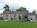
 / 53.26564; -1.81628 (Knotlow Farmhouse and outbuilding)
Knotlow Farmhouse And Attached Outbuilding.jpg
Late 18th centuryThe farmhouse, which incorporates material from a 17th-century house, and the attached outbuilding, are in rendered limestone, and have stone slate roofs with a coped north west gable and moulded kneelers. The house has two storeys and three bays, and contains two doorways and sash windows. The outbuilding to the right has a single storey and an overloft, a single bay, and a doorway. [18] II
Barn south-southeast of Knotlow Farmhouse
53°15′55″N1°48′58″W / 53.26538°N 1.81606°W / 53.26538; -1.81606 (Barn south-southeast of Knotlow Farmhouse)
Late 18th centuryThe barn is in limestone with gritstone dressings, quoins and a stone slate roof. There are two storeys and ten bays. In the centre is a full-height segmental-arched cart entrance with a quoined surround, and there are three doorways, also with quoined surrounds. [19] II
Barn west of Old Hall Farmhouse
53°16′04″N1°49′11″W / 53.26785°N 1.81986°W / 53.26785; -1.81986 (Barn west of Old Hall Farmhouse)
Barn To The West Of Old Hall Farmhouse.jpg
Late 18th centuryThe barn is in limestone with gritstone dressings, quoins and a stone slate roof. There are two storeys and five bays, and it contains five doorways with plain lintels. [20] II
The Vicarage
53°15′54″N1°48′53″W / 53.26493°N 1.81485°W / 53.26493; -1.81485 (The Vicarage)
The Vicarage, Wormhill.jpg
Late 18th centuryThe vicarage is in limestone, roughcast on the garden front, with gritstone dressings, rusticated quoins, a moulded eaves band, and a slate roof. There are two storeys and three bays. In the centre is a canted bay window, and the other windows are sashes. On the east gable end is a single-storey porch. [21] II
Hassop Farmhouse
53°15′45″N1°49′01″W / 53.26251°N 1.81694°W / 53.26251; -1.81694 (Hassop Farmhouse)
Hassop Farmhouse 2.jpg
c. 1800The farmhouse is in roughcast limestone with gritstone dressings, and a Welsh slate roof with coped gables and moulded kneelers. There are two storeys and three bays. The doorway has a plain surround and a shallow bracketed hood, and the windows are sashes. [22] II
House east of Bateman's Farm
53°15′58″N1°49′01″W / 53.26602°N 1.81681°W / 53.26602; -1.81681 (House east of Bateman's Farm)
House To The East Of Bateman's Farm.jpg
Early 19th centuryThe house, at one time a farmhouse and an inn, is in limestone with gritstone dressings, rusticated quoins, and a stone slate roof. There are two storeys, three bays, and a two-bay parallel range at the rear. In the centre is a doorway with a shallow bracketed hood, and the windows are sashes. [23] II
Elm Tree House
53°16′02″N1°49′01″W / 53.26735°N 1.81708°W / 53.26735; -1.81708 (Elm Tree House)
Elm Tree House.jpg
Early 19th centuryThe house is in roughcast limestone with gritstone dressings, quoins, an eaves band, and a hipped Welsh slate roof. There are two storeys and three bays. The central doorway has a semicircular head, Gothic glazing bars, and a shallow bracketed hood. The windows are sashes, the window above the doorway with a semicircular head. [24] II
Gate piers and walls,
St Margaret's Church
53°15′53″N1°48′56″W / 53.26480°N 1.81558°W / 53.26480; -1.81558 (Gate piers and walls, St Margaret's Church)
Mid 19th centuryThe boundary walls enclosing the churchyard are in limestone. At the entrance are square gritstone gate piers with projecting moulded caps and cone finials on tapered stems. [25] II
South Viaduct
53°15′21″N1°47′31″W / 53.25578°N 1.79205°W / 53.25578; -1.79205 (South Viaduct)
Miller's Dale - south railway viaduct from lime kilns - geograph.org.uk - 625677.jpg
1862–63The viaduct was built by the Midland Railway to carry its line over the River Wye. The piers and abutments are in limestone with gritstone dressings, and the superstructure is in wrought iron. It consists of three round-arched masonry spans to the west and three wrought iron spans to the east, about 80 feet (24 m) above the ground. Each arch consists of five parallel ribs with latticework strutting filling the spandrels. [26] [27] II*
Brindley Memorial Fountain
53°15′54″N1°49′02″W / 53.26513°N 1.81733°W / 53.26513; -1.81733 (Brindley Memorial Fountain)
The Brindley Memorial Fountain.jpg
1875A well in gritstone as a memorial to the civil engineer James Brindley. The fountain head is gabled and has carved copings. It contains seating, it is surrounded by steps and stepped walls, and in front of it are three stone troughs. [4] [28] II
Outbuilding south-southeast of the House east of Bateman's Farm
53°15′57″N1°49′00″W / 53.26591°N 1.81662°W / 53.26591; -1.81662 (Outbuilding south-southeast of the House east of Bateman's Farm)
Outbuilding To The South South East Of House To The East Of Bateman's Farm.jpg
Late 19th centuryThe outbuilding is in limestone with quoins and a stone slate roof. There are two storeys and three bays. The windows have heavy stone frames, those in the ground floor with segmental-arched heads. In the upper floor is a taking-in door, and an inserted inscribed and dated plaque. [29] II
Outbuilding southwest of the House east of Bateman's Farm
53°15′57″N1°49′00″W / 53.26579°N 1.81676°W / 53.26579; -1.81676 (Outbuilding southwest of the House east of Bateman's Farm)
Outbuilding To The South West Of House To The East Of Batemans Farm.jpg
Late 19th centuryThe outbuilding is in limestone with gritstone dressings and a stone slate roof. There are two storeys and three bays. It contains a full-height cart entry with a quoined surround and a segmental-arched head, blocked and containing an inserted doorway with a quoined surround. There are two ground floor windows with quoined surrounds, and two upper floor openings with plain stone frames. [30] II

Related Research Articles

Ashover is a civil parish in the North East Derbyshire district of Derbyshire, England. The parish contains 83 listed buildings that are recorded in the National Heritage List for England. Of these, one is listed at Grade I, the highest of the three grades, and the others are at Grade II, the lowest grade. The parish is almost entirely rural, and contains the village of Ashover and smaller settlements, including Milltown and Ashover Hay. Most of the listed buildings are farmhouses and farmbuildings, houses, cottages, and associated structures. The other listed buildings include a church and items in the churchyard, chapels, public houses, a footbridge and a road bridge, a former watermill and a windmill, a pinfold, the chimney of a former engine house, a former school, and a telephone kiosk.

Ballidon is a civil parish in the Derbyshire Dales district of Derbyshire, England. The parish contains 15 listed buildings that are recorded in the National Heritage List for England. All the listed buildings are designated at Grade II, the lowest of the three grades, which is applied to "buildings of national importance and special interest". The parish contains the villages of Ballidon and Pikehall, and Ballidon Quarry, and is otherwise entirely rural. Most of the listed buildings are farmhouses and farm buildings, two of which has been converted for other uses by the quarry. The other listed buildings are a church, a milestone, a lime kiln, and an embankment and bridge, originally carrying a railway, and later part of the High Peak Trail.

Barlow is a civil parish in the North East Derbyshire district of Derbyshire, England. The parish contains 18 listed buildings that are recorded in the National Heritage List for England. Of these, three are listed at Grade II*, the middle of the three grades, and the others are at Grade II, the lowest grade. The parish contains the village of Barlow and the surrounding countryside, mainly to the west of the village. It is almost entirely rural, and the listed buildings are mainly houses and associated structures, farmhouses and farm buildings. The other listed buildings are a church, its former rectory, a bridge, a former school, a pinfold, and a village pump.

Beeley is a civil parish in the Derbyshire Dales district of Derbyshire, England. The parish contains 20 listed buildings that are recorded in the National Heritage List for England. Of these, three are listed at Grade II*, the middle of the three grades, and the others are at Grade II, the lowest grade. The parish contains the village of Beeley and the surrounding countryside and moorland, mainly to the east of the village. Most of the listed buildings are houses, cottages, and associated structures. The other listed buildings include a church, a public house, a guide post and guide stone, a farmhouse, a converted barn, a former school, and a former vicarage.

Bradbourne is a civil parish in the Derbyshire Dales district of Derbyshire, England. The parish contains 16 listed buildings that are recorded in the National Heritage List for England. Of these, one is listed at Grade I, the highest of the three grades, one is at Grade II*, the middle grade, and the others are at Grade II, the lowest grade. The parish contains the village of Bradbourne and the surrounding countryside. The listed buildings consist of houses, cottages and associated structures, farmhouses and farm buildings, a church and items in the churchyard, and a former watermill and associated buildings.

Bretby is a civil parish in the South Derbyshire district of Derbyshire, England. The parish contains 13 listed buildings that are recorded in the National Heritage List for England. Of these, two are listed at Grade II*, the middle of the three grades, and the others are at Grade II, the lowest grade. The parish contains the village of Bretby and the surrounding countryside. The listed buildings include houses, cottages and associated structures, a farmhouse and farm buildings, a church, a former school, a former watermill, a bottle kiln and factory, a war memorial and village pump, and a telephone kiosk.

Castleton is a civil parish in the High Peak district of Derbyshire, England. The parish contains 25 listed buildings that are recorded in the National Heritage List for England. Of these, one is listed at Grade I, the highest of the three grades, one is at Grade II*, the middle grade, and the others are at Grade II, the lowest grade. The parish contains the village of Castleton and the surrounding countryside and moorland. The most important building in the parish is the ruined Peveril Castle, which is listed at Grade I. The other listed buildings include houses, cottages and associated structures, farmhouses and farm buildings, a church and a sundial in the churchyard, a hotel and a public house, a former watermill, three mileposts, a school, a war memorial, and a telephone kiosk.

Dethick, Lea and Holloway is a civil parish in the Amber Valley district of Derbyshire, England. The parish contains 36 listed buildings that are recorded in the National Heritage List for England. Of these, five are listed at Grade II*, the middle of the three grades, and the others are at Grade II, the lowest grade. The parish contains the villages of Dethick, Lea, and Holloway, and the surrounding area. Most of the listed buildings are country houses, smaller houses, cottages, and associated structures. The other listed buildings include churches and chapels, a public house, farmhouses and farm buildings, and a bridge.

Eckington is a civil parish in the North East Derbyshire district of Derbyshire, England. The parish contains 81 listed buildings that are recorded in the National Heritage List for England. Of these, two are listed at Grade I, the highest of the three grades, two are at Grade II*, the middle grade, and the others are at Grade II, the lowest grade. The parish contains the town of Eckington, the villages of Renishaw, Ridgeway, and Spinkhill, the hamlet of Birley Hay, and the surrounding countryside. The major building in the parish is the country house, Renishaw Hall, which is listed, together with associated structures and items in its grounds. Most of the other listed buildings are houses, cottages and associated structures, farmhouses and farm buildings. The rest of the listed buildings include churches, chapels and associated items, a former Sunday school, a former toll house, a public house, and two bridges.

Hathersage is a civil parish in the Derbyshire Dales district of Derbyshire, England. The parish contains 54 listed buildings that are recorded in the National Heritage List for England. Of these, one is listed at Grade I, the highest of the three grades, three are at Grade II*, the middle grade, and the others are at Grade II, the lowest grade. The parish, which is almost entirely rural, contains the village of Hathersage and the surrounding countryside. Most of the listed buildings are farmhouses and farm buildings, houses, cottages, and associated structures. The other listed buildings include two churches, a cross shaft in a churchyard, a presbytery and a vicarage, two bridges, former mills, a milepost, a former toll house, a railway viaduct, and a lamp column.

Holmesfield is a civil parish in the North East Derbyshire district of Derbyshire, England. The parish contains 41 listed buildings that are recorded in the National Heritage List for England. Of these, five are listed at Grade II*, the middle of the three grades, and the others are at Grade II, the lowest grade. The parish contains the village of Holmesfield, the hamlet of Cartledge, and the surrounding countryside and moorland. Most of the listed buildings are houses, cottages and associated structures, farmhouses, and farm buildings. The other listed buildings include two medieval crosses, a cross dated 1619, a church, public houses, a former toll house, a milepost, and two milestones.

Hope is a civil parish in the High Peak district of Derbyshire, England. The parish contains 23 listed buildings that are recorded in the National Heritage List for England. Of these, one is listed at Grade I, the highest of the three grades, and the others are at Grade II, the lowest grade. The parish contains the village of Hope and the surrounding countryside. Most of the listed buildings are houses, farmhouses and farm buildings. The other listed buildings include a church and items in the churchyard, a cross converted into a guide post, a hotel, a former toll house, two mileposts, the engine house and chimney of a former lead mine, a school, and a war memorial.

Kirk Ireton is a civil parish in the Derbyshire Dales district of Derbyshire, England. The parish contains 27 listed buildings that are recorded in the National Heritage List for England. Of these, one is listed at Grade I, the highest of the three grades, one is at Grade II*, the middle grade, and the others are at Grade II, the lowest grade. The parish contains the village of Kirk Ireton and the surrounding countryside. Most of the listed buildings are houses, cottages and associated structures, farmhouses and farm buildings, and the others are churches and associated structures, and a public house.

Longford is a civil parish in the Derbyshire Dales district of Derbyshire, England. The parish contains 22 listed buildings that are recorded in the National Heritage List for England. Of these, one is listed at Grade I, the highest of the three grades, four are at Grade II*, the middle grade, and the others are at Grade II, the lowest grade. The parish contains the village of Longford and the surrounding area. The major building in the parish is Longford Hall, which is listed, together with associated structures, and the adjacent farm and farm buildings. The other listed buildings include a church, a cross and tombs in the churchyard, houses and cottages, farmhouses, a row of almshouses, now in ruins, two bridges, a former watermill, and a former cheese factory.

Netherseal is a civil parish in the South Derbyshire district of Derbyshire, England. The parish contains eleven listed buildings that are recorded in the National Heritage List for England. Of these, three are listed at Grade II*, the middle of the three grades, and the others are at Grade II, the lowest grade. The parish contains the village of Netherseal and the surrounding countryside. The listed buildings consist of a church and churchyard walls, a chapel, houses and associated structures, a pigeoncote, a former smithy, a row of almshouses, a farmhouse and a former watermill.

Somersal Herbert is a civil parish in the Derbyshire Dales district of Derbyshire, England. The parish contains twelve listed buildings that are recorded in the National Heritage List for England. Of these, one is listed at Grade I, the highest of the three grades, one is at Grade II*, the middle grade, and the others are at Grade II, the lowest grade. The parish contains the village of Somersal Herbert and the surrounding area. The major building in the parish is Somersal Herbert Hall, which is listed, together with associated structures. The other listed buildings are houses, a farmhouse, cottages and associated structures, a church and its lychgate, a churchyard cross and a telephone kiosk.

Swarkestone is a civil parish in the South Derbyshire district of Derbyshire, England. The parish contains 19 listed buildings that are recorded in the National Heritage List for England. Of these, one is listed at Grade I, the highest of the three grades, three are at Grade II*, the middle grade, and the others are at Grade II, the lowest grade. The parish contains the village of Swarkestone and the surrounding area. The Trent and Mersey Canal passes through the northern part of the parish, and the listed buildings associated with it are bridges, a lock, mileposts, and a former toll house with an outbuilding. The other listed buildings include houses and associated structures, farmhouses and farm buildings, a church and a cross in the churchyard, a public house and its former stable block, and former reading rooms.

Yeaveley is a civil parish in the Derbyshire Dales district of Derbyshire, England. The parish contains nine listed buildings that are recorded in the National Heritage List for England. Of these, one is listed at Grade I, the highest of the three grades, one is at Grade II*, the middle grade, and the others are at Grade II, the lowest grade. The parish contains the village of Yeaveley and the surrounding countryside. The oldest listed building in the parish consists of the remains of a preceptory of the Knights Hospitaller. The other listed buildings are houses and associated structures, farmhouses and farm buildings, and a church.

Yeldersley is a civil parish in the Derbyshire Dales district of Derbyshire, England. The parish contains 14 listed buildings that are recorded in the National Heritage List for England. All the listed buildings are designated at Grade II, the lowest of the three grades, which is applied to "buildings of national importance and special interest". The parish is almost entirely rural, with no substantial settlements, and the listed buildings consist of houses, cottages and associated structures, farmhouses and farm buildings, and a milepost.

Youlgreave is a civil parish in the Derbyshire Dales district of Derbyshire, England. The parish contains 57 listed buildings that are recorded in the National Heritage List for England. Of these, one is listed at Grade I, the highest of the three grades, one is at Grade II*, the middle grade, and the others are at Grade II, the lowest grade. The parish contains the village of Youlgreave, the hamlet of Alport and the surrounding countryside. Most of the listed buildings are houses, cottages and associated structures, farmhouses and farm buildings. The other listed buildings include a church and associated structures, a public house, bridges, a milestone, a conduit head, a school, a youth hostel and a telephone kiosk.

References

Citations

Sources