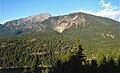
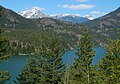
Little Jack

Last updated
Little Jack
Little Jack Mountain in North Cascades mountain range seen from Highway 20.jpg
Little Jack seen from the west on North Cascades Highway
Highest point
Elevation 6,745 ft (2,056 m) [1]
Prominence 625 ft (191 m) [1]
Parent peak Jack Mountain (9,066 ft) [2]
Isolation 2.24 mi (3.60 km) [2]
Coordinates 48°44′38″N120°58′43″W / 48.743847°N 120.978533°W / 48.743847; -120.978533 [1]
Geography
USA Washington relief location map.jpg
Red triangle with thick white border.svg
Little Jack
Location in Washington
Usa edcp relief location map.png
Red triangle with thick white border.svg
Little Jack
Little Jack (the United States)
Location Whatcom County, Washington, U.S.
Parent range North Cascades
Topo map USGS Crater Mountain
Climbing
Easiest route Hiking trail

Little Jack is a 6,745-foot-elevation mountain summit in the North Cascades Range of Washington, United States. It is located within the Pasayten Wilderness. It is situated one mile south of its namesake Jack Mountain, west of Crater Mountain, and east of Ross Lake. Like many North Cascade peaks, Little Jack is more notable for its large, steep rise above local terrain than for its absolute elevation. In the early 1900s, the Forest Service built the Little Jack Trail for the purpose of grazing pack animals on the meadows of Little Jack Mountain. [3] The name "Jack" honors Jack Rowley, a gold prospector in the area during the late 1800s, who was credited with finding gold at Ruby Creek. [4]

Contents

Climate

Little Jack is located in the marine west coast climate zone of western North America. [5] Most weather fronts originate in the Pacific Ocean, and travel east toward the Cascade Mountains. As fronts approach the North Cascades, they are forced upward by the peaks of the Cascade Range, causing them to drop their moisture in the form of rain or snowfall onto the Cascades (Orographic lift). As a result, the west side of the North Cascades experiences high precipitation, especially during the winter months in the form of snowfall. [5] During winter months, weather is usually cloudy, but, due to high pressure systems over the Pacific Ocean that intensify during summer months, there is often little or no cloud cover during the summer. [6] Because of maritime influence, snow tends to be wet and heavy, resulting in high avalanche danger. [5] Precipitation runoff from the mountain drains into the Skagit River.

Geology

The North Cascades features some of the most rugged topography in the Cascade Range with craggy peaks, ridges, and deep glacial valleys. The history of the formation of the Cascade Mountains dates back millions of years ago to the late Eocene Epoch. [7] With the North American Plate overriding the Pacific Plate, episodes of volcanic igneous activity persisted. [7] In addition, small fragments of the oceanic and continental lithosphere called terranes created the North Cascades about 50 million years ago. [7] Little Jack Mountain is part of the Little Jack terrane. Outcrops of granite and fine-grained mica schist can be found on the top of Little Jack Mountain. [3] During the Pleistocene period dating back over two million years ago, glaciation advancing and retreating repeatedly scoured the landscape leaving deposits of rock debris. [7] The U-shaped cross section of the river valleys is a result of recent glaciation. Uplift and faulting in combination with glaciation have been the dominant processes which have created the tall peaks and deep valleys of the North Cascades area.

See also

Related Research Articles

<span class="mw-page-title-main">Klawatti Peak</span> Mountain in Washington (state), United States

Klawatti Peak is located in North Cascades National Park in the U.S. state of Washington. Klawatti Peak is a nunatak, a peak surrounded by glaciers. These are Klawatti Glacier to the east, McAllister Glacier to the northwest and Inspiration Glacier to the south.

<span class="mw-page-title-main">Tower Mountain (Washington)</span> Mountain in Washington (state), United States

Tower Mountain is a prominent non-volcanic mountain located on the boundary line of Okanogan and Skagit counties in Washington state. It is part of the Okanogan Range which is a sub-range of the North Cascades Range. Tower Mountain situated on land administered by the Okanogan–Wenatchee National Forest.

<span class="mw-page-title-main">Gunn Peak</span> Mountain in Washington (state), United States

Gunn Peak is a 6,244-foot (1,903-metre) mountain summit located in Snohomish County, Washington. The mountain is part of the Cascade Range. Gunn Peak is the highest point of the Wild Sky Wilderness. The mountain was named for homesteader/miner Amos Gunn who started the nearby town of Index, Washington, and also named nearby Mount Index. Precipitation runoff from the mountain drains into tributaries of the Skykomish River.

<span class="mw-page-title-main">Cutthroat Peak</span> Mountain in Washington (state), United States

Cutthroat Peak is an 8,050-foot-elevation (2,450-meter) granitic mountain located on the boundary of Chelan County and Skagit County, in Washington state. The mountain is part of the Okanagan Range which is a subset of the Cascade Range, and is situated within the Okanogan-Wenatchee National Forest. Cutthroat Peak is about two miles west of Washington Pass and one mile east of Rainy Pass. It's a prominent landmark along the North Cascades Highway with an accessible climbing route. There is also a Cutthroat Lake, Cutthroat Creek, and Cutthroat Pass on its north and east aspects. This geographical feature's name was officially adopted in 1988 by the United States Board on Geographic Names. Molar Tooth is a granite pillar half a mile north on the ridge extending to Cutthroat Pass.

<span class="mw-page-title-main">The Needles (Washington)</span> Mountain in Washington (state), United States

The Needles is an 8,160-foot (2,490-metre) granite mountain located in Okanogan County in Washington state. It is part of the Okanogan Range which is a sub-range of the North Cascades Range. The Needles is situated on land administered by the Okanogan–Wenatchee National Forest. The nearest higher peak is Tower Mountain, 2.26 miles (3.64 km) to the southwest.

<span class="mw-page-title-main">Whistler Mountain (Washington)</span> Mountain in Washington (state), United States

Whistler Mountain is a 7,790-foot (2,370-metre) mountain summit located in Chelan County of Washington state. The mountain is part of the Okanagan Range which is a sub-range of the North Cascades. Whistler Mountain is about two miles west of Washington Pass and one mile east of Rainy Pass. The North Cascades Highway bends around the southern base of the mountain between these two passes. A high ridge connects Whistler to its nearest higher neighbor, Cutthroat Peak, which is 0.78 miles (1.26 km) to the north-northeast. Precipitation runoff from the peak drains into Bridge Creek. Topographic relief is significant as the summit rises over 3,000 feet above the creek and highway in approximately one mile.

<span class="mw-page-title-main">Fisher Peak (Washington)</span> Mountain in Washington (state), United States

Fisher Peak is an 8,040-foot-elevation mountain summit located in the North Cascades of Washington state. It is situated on the borders of the Stephen Mather Wilderness and North Cascades National Park, midway between Black Peak and Easy Pass, and adjacent to Repulse Peak. Precipitation runoff from Fisher Peak drains into tributaries of the Skagit River.

<span class="mw-page-title-main">Trapper Mountain</span> Mountain in Washington (state), United States

Trapper Mountain is a 7,530-foot (2,300-metre) summit located in Chelan County of Washington state. It is part of the North Cascades Range. Trapper Mountain is situated southeast of Cascade Pass on the shared border of North Cascades National Park and Glacier Peak Wilderness. The nearest higher peak is Hurry-up Peak, 0.92 miles (1.48 km) to the west. Surface runoff from the mountain drains into Trapper Lake and tributaries of the Stehekin River.

<span class="mw-page-title-main">Vasiliki Ridge</span>

Vasiliki Ridge is a three-mile-long ridge located in Okanogan County of Washington state. It is part of the Methow Mountains which is a sub-range of the North Cascades. Vasiliki Ridge is situated north of Silver Star Mountain on land administered by the Okanogan–Wenatchee National Forest. The name Vasiliki was recommended by climber Fred Beckey who made the first ascent in 1952. Vasiliki Ridge can be seen from Washington Pass and from the North Cascades Highway.

<span class="mw-page-title-main">Jumbo Mountain</span> Mountain in Washington (state), United States

Jumbo Mountain, is a 5840+ ft summit near the western edge of the North Cascades, in Snohomish County of Washington state. It is located four miles south of Darrington, Washington, along the Mountain Loop Highway. It is situated in the Boulder River Wilderness on land administered by the Mount Baker-Snoqualmie National Forest. The mountain was named by miners for its resemblance to an elephant. The nearest higher peak is Buckeye Peak, 3.34 miles (5.38 km) to the west. Precipitation runoff from Jumbo Mountain drains into tributaries of the Stillaguamish River and Sauk River.

<span class="mw-page-title-main">Enchantment Peak</span> Mountain in Washington (state), United States

Enchantment Peak is an 8,520+ ft granite summit located in Chelan County of Washington state. Enchantment Peak is part of The Enchantments within the Alpine Lakes Wilderness. Enchantment Peak belongs to the Stuart Range which is subset of the Cascade Range. Enchantment Peak is situated midway between Prusik Peak to its east, and Aasgard Pass and Dragontail Peak to the west. Precipitation runoff drains into Icicle Creek, a tributary of the Wenatchee River.

<span class="mw-page-title-main">Jabberwocky Tower</span>

Jabberwocky Tower is a 6,840-foot-elevation granite spire located in Chelan County of Washington state. Jabberwocky Tower is part of The Enchantments within the Alpine Lakes Wilderness. It belongs to the Stuart Range which is subset of the Cascade Range. Jabberwocky Tower is situated east of Colchuck Lake and west of Enchantment Peak. Precipitation runoff drains into Icicle Creek, a tributary of the Wenatchee River.

<span class="mw-page-title-main">Pierce Mountain (Washington)</span> Mountain in Washington (state), United States

Pierce Mountain is a 4,973+ ft summit in the North Cascades Range of Washington, United States. It is located within North Cascades National Park and Stephen Mather Wilderness. It is situated above Ross Dam, at the eastern culmination of Sourdough Mountain. Like many North Cascade peaks, Pierce Mountain is more notable for its large, steep rise above local terrain than for its absolute elevation. Precipitation runoff from the mountain drains into the Skagit River via Pierce Creek and Ross Lake.

<span class="mw-page-title-main">Holliway Mountain</span> Mountain in Washington (state), United States

Holliway Mountain is an 8000+ ft granite summit located in Okanogan County in Washington state. It is part of the Okanogan Range which is a sub-range of the North Cascades Range. Holliway Mountain is situated near the headwaters of the Methow River on land administered by the Okanogan–Wenatchee National Forest. The nearest higher peak is Golden Horn, 0.91 miles (1.46 km) to the south. Azurite Peak is located three miles to the north-northwest.

<span class="mw-page-title-main">Constitution Crags</span> Mountain in Washington (state), United States

Constitution Crags is a 6,978-foot-elevation summit located in Okanogan County of Washington state. It is part of the Okanogan Range which is a sub-range of the North Cascades. Constitution Crags is situated west of Silver Star Mountain on land administered by the Okanogan–Wenatchee National Forest. The nearest higher neighbor is Hinkhouse Peak, 0.62 mile to the southwest. Washington Pass is located over a mile south of Constitution Crags, and the North Cascades Highway traverses below the east face of Constitution Crags. Like many North Cascade peaks, Constitution Crags is more notable for its large, steep rise above local terrain than for its absolute elevation. Precipitation runoff from the peak drains into Early Winters Creek which is a tributary of the Methow River.

<span class="mw-page-title-main">Tricouni Peak (Washington)</span> Mountain in Washington (state), United States

Tricouni Peak is an 8,102-foot (2,469-metre) mountain summit located in Skagit County of Washington state. It is situated in North Cascades National Park, north of the North Klawatti Glacier and southeast of the Borealis Glacier. Its nearest higher peak is Primus Peak, 0.54 mi (0.87 km) to the west. Precipitation runoff from Tricouni drains into Thunder Creek. The peak is named for the tricouni which was used for traction on ice, and the approach to the peak involves traversing a glacier.

<span class="mw-page-title-main">Mount Lago</span> Mountain in Washington (state), United States

Mount Lago is a prominent 8,745-foot (2,665-metre) mountain summit located in the Okanogan Range of the North Cascades, in Okanogan County of Washington state. The mountain is situated on the eastern side of the Cascade crest, in the Pasayten Wilderness, on land managed by the Okanogan–Wenatchee National Forest. The nearest higher peak is Jack Mountain, 19.5 miles (31.4 km) to the west-southwest. Mount Lago is the highest summit of the Okanogan Range, and follows only Jack Mountain {9,075 ft} as the highest peak in the Pasayten Wilderness. Lago is the fourth-most prominent mountain in the Pasayten Wilderness. Precipitation runoff from the mountain drains into tributaries of the Pasayten River and Methow River. The mountain was named for Lage Wernstedt (1878-1959), a Forest Service surveyor who made numerous first ascents of the mountains he was mapping in the North Cascades. Lago, is a play on the way Americans pronounced his name. Lage, pronounced Loggy, had a son named Lago.

<span class="mw-page-title-main">Castle Peak (Washington)</span> Mountain in Washington (state), United States

Castle Peak is a prominent 8,306-foot (2,532-metre) mountain summit located in the Hozameen Range of the North Cascades, on the shared border between Okanogan County and Whatcom County of Washington state. The mountain is situated 1 mile (1.6 km) south of the Canada–United States border, on the Cascade crest, in the Pasayten Wilderness, on land managed by the Okanogan–Wenatchee National Forest. The nearest higher peak is Jack Mountain, 14.8 miles (23.8 km) to the south-southwest. Castle Peak is the second highest summit of the Hozameen Range following Jack Mountain. Castle Peak is the fifth-most prominent mountain in the Pasaten Wilderness. Precipitation runoff from the mountain drains east into Castle Creek, a tributary of the Similkameen River, or west into tributaries of the Skagit River.

<span class="mw-page-title-main">The Cradle (Washington)</span> Mountain in Washington (state), United States

The Cradle is a prominent 7,467-foot (2,276-metre) double summit mountain located in Chelan County of Washington state. The mountain's name is derived from the depression between the two peaks of nearly identical elevation. The Cradle is situated within the Alpine Lakes Wilderness and is part of the Wenatchee Mountains, which is subset of the Cascade Range. Its nearest higher peak is Jack Ridge, 5.7 mi (9.2 km) to the east-southeast. Precipitation runoff from the mountain drains into tributaries of Icicle Creek, which in turn is a tributary of the Wenatchee River. The first ascent of the south peak was made in 1944 by Gene Paxton and Dwight Watson, whereas the north peak wasn't climbed until 1952 by Bill and Gene Prater.

<span class="mw-page-title-main">Jackita Ridge</span>

Jackita Ridge is a prominent 7,350 ft (2,240 m) ridge located in the Pasayten Wilderness, in Whatcom County of Washington state. It is part of the Hozameen Range which is a subset of the North Cascades. The highest point is called Jackita Peak, and the Jackita Ridge Trail traverses below the west aspect of this summit, providing access for an off-trail scramble to the top. The nearest higher neighbor is Crater Mountain, 3.9 miles (6.3 km) to the southwest, Jack Mountain is set 4.77 miles (7.68 km) to the west, and McKay Ridge is 5.7 miles (9.2 km) to the south. Precipitation runoff from this ridge drains to Ross Lake via Devils Creek and Canyon Creek, which are part of the Skagit River drainage basin. The first ascent may have been made in 1926 by the United States Coast and Geodetic Survey, which placed a Jackita benchmark.

References

  1. 1 2 3 "Little Jack, Washington". Peakbagger.com.
  2. 1 2 "Little Jack - 6,745' WA". listsofjohn.com. Retrieved 2021-03-09.
  3. 1 2 Geology of the North Cascades: A Mountain Mosaic. by Rowland W. Tabor, Ralph Albert Haugerudme. The Mountainers publisher. 1999
  4. Majors, Harry M. (1975). Exploring Washington. Van Winkle Publishing Co. ISBN   978-0-918664-00-6.
  5. 1 2 3 Beckey, Fred W. (1996). Cascade Alpine Guide, Volume 3 (2nd ed.).
  6. Beckey, p. 16
  7. 1 2 3 4 Kruckeberg, Arthur (1991). The Natural History of Puget Sound Country. University of Washington Press.