Llanbedr-Dyffryn-Clwyd | |
---|---|
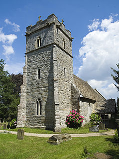
St Peter's Church, Llanbedr-Dyffryn-Clwyd | |
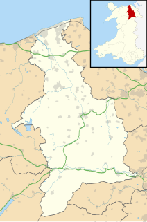
Location within Denbighshire | |
Population | 787 (2011) |
OS grid reference | SJ145595 |
Community |
|
Principal area | |
Ceremonial county | |
Country | Wales |
Sovereign state | United Kingdom |
Post town | RUTHIN |
Postcode district | LL15 |
Dialling code | 01824 |
Police | North Wales |
Fire | North Wales |
Ambulance | Welsh |
EU Parliament | Wales |
UK Parliament | |
Welsh Assembly | |
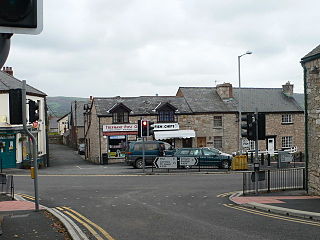
Llanbedr-Dyffryn-Clwyd is a small village and community in Denbighshire in Wales, approximately 2 miles north-east of the town of Ruthin on the main A494 road towards Chester.
A community is a division of land in Wales that forms the lowest tier of local government in Wales. Welsh communities are analogous to civil parishes in England. In 2016 there were 870 communities in Wales.
Denbighshire is a county in north-east Wales, named after the historic county of Denbighshire, but with substantially different borders. Denbighshire is the longest known inhabited part of Wales. Pontnewydd (Bontnewydd-Llanelwy) Palaeolithic site has Neanderthal remains from 225,000 years ago. Its several castles include Denbigh, Rhuddlan, Ruthin, Castell Dinas Bran and Bodelwyddan. St Asaph, one of the smallest cities in Britain, has one of the smallest Anglican cathedrals. Denbighshire has a length of coast to the north and hill ranges to the east, south and west. In the central part, the River Clwyd has created a broad fertile valley. It is primarily a rural county with little industry. Crops are grown in the Vale of Clwyd and cattle and sheep reared in the uplands. The coast attracts summer tourists, and hikers frequent the Clwydian Range, which forms an Area of Outstanding Natural Beauty with the upper Dee Valley. Llangollen hosts the Llangollen International Musical Eisteddfod in each July.
Wales is a country that is part of the United Kingdom. It is bordered by England to the east, the Irish Sea to the north and west, and the Bristol Channel to the south. It had a population in 2011 of 3,063,456 and has a total area of 20,779 km2 (8,023 sq mi). Wales has over 1,680 miles (2,700 km) of coastline and is largely mountainous with its higher peaks in the north and central areas, including Snowdon, its highest summit. The country lies within the north temperate zone and has a changeable, maritime climate.
There are several places called Llanbedr in Wales, as the word literally translates to 'church of St. Peter' in English. There are two churches called St Peter's in Llanbedr D.C. (as it is sometimes abbreviated to), the original medieval church of St. Peter and still stands as a Grade 2 listed ruin near Llanbedr Hall, and the present parish church of St. Peter, also Grade 2 listed, is alongside the A494 dedicated in 1864, part of the Deanery of Dyffryn Clwyd in the Diocese of St. Asaph. [1]
Llanbedr is a village in Gwynedd, Wales.
A parish church in Christianity is the church which acts as the religious centre of a parish. In many parts of the world, especially in rural areas, the parish church may play a significant role in community activities, often allowing its premises to be used for non-religious community events. The church building reflects this status, and there is considerable variety in the size and style of parish churches. Many villages in Europe have churches that date back to the Middle Ages, but all periods of architecture are represented.
A deanery is an ecclesiastical entity in the Roman Catholic Church, the Anglican Communion, the Evangelical Church in Germany, and the Church of Norway. A deanery is either the jurisdiction or residence of a dean.
In 1831 the parish had a population of 527, a number which fell to 285 by the time of the 1901 census. [2] In the 2011 census the population of Llanbedr was 787.
Llanbedr Dyffryn Clwyd is part of the electoral ward called Llanbedr Dyffryn Clwyd/Llangynhafal. This ward had a total population in the 2011 census of 1,421. [3]
The wards and electoral divisions in the United Kingdom are electoral districts at sub-national level represented by one or more councillors. The ward is the primary unit of English electoral geography for civil parishes and borough and district councils, electoral ward is the unit used by Welsh principal councils, while the electoral division is the unit used by English county councils and some unitary authorities. Each ward/division has an average electorate of about 5,500 people, but ward-population counts can vary substantially. As at the end of 2014 there were 9,456 electoral wards/divisions in the UK.
Ruthin is the county town of Denbighshire in north Wales and a community in the southern part of the Vale of Clwyd. The older town, the castle and St Peter's Square lie on a hill, but many newer parts in the flood plain of the River Clwyd. This emerged several times in the late 1990s – flood-control works costing £3 million were completed in autumn 2003. Ruthin is skirted by villages such as Pwllglas and Rhewl. The name comes from the Welsh words rhudd (red) and din (fort), reflecting the colour of the sandstone bedrock, of which the castle was built in 1277–1284. The original name was Castell Coch yng Ngwern-fôr. The mill is nearby. Maen Huail is a registered ancient monument attributed to the brother of Gildas and King Arthur, located outside Barclays Bank in St Peter's Square.
Llanrwst is a small market town and community on the A470 road and the River Conwy, in Conwy County Borough, Wales. It developed around the wool trade and became known also for the making of harps and clocks. Today, less than a mile from the edge of Snowdonia, its main industry is tourism. Notable buildings include almshouses, two 17th-century chapels, and the Parish Church of St Grwst, which holds a stone coffin of Llywelyn the Great. The 2011 census gave the town a population of 3,323.
Crickhowell is a small town and community in southeastern Powys, Wales, near Abergavenny, and was in the historic county of Brecknockshire.
Clwyd West is a constituency of the House of Commons of the Parliament of the United Kingdom. It elects one Member of Parliament (MP) by the first past the post method of election. The current MP is David Jones of the Conservative Party, first elected at the 2005 general election and who also served as Secretary of State for Wales from 4 September 2012 until 14 July 2014.
Llangernyw is a rural, mostly Welsh-speaking, village and community in Conwy County Borough, Wales.
Llandyrnog is a large village and community in Denbighshire, Wales lying in the valley of the River Clwyd, about 3 miles (4.8 km) from Denbigh and 5 miles (8.0 km) from Ruthin. The village has good road links to Denbigh and the main A541 road at Bodfari, and is served by buses number 76 and 53. The village contains the Church of St. Tyrnog's is a Grade II* listed building, and has a notable creamery on the outskirts and former hospital.
Marshfield is an electoral ward and community in Newport in Wales governed by the Newport City Council. Population, 4,245 increasing to 6,270 at the 2011 census.
Betws yn Rhos is a village and community in Conwy County Borough, Wales.
Easton is a small village and civil parish in Norfolk, England, to the west of Norwich. It covers an area of 6.25 km2 (2.41 sq mi) and had a population of 1,141 in 445 households at the 2001 census, the population increasing to 1,514 at the 2011 Census. Located close to the Royal Norfolk Showground and the A47, it also houses a campus of Easton & Otley College, a large agricultural college, in the Grade II listed 18th-century Easton Hall.
Llanarmon Dyffryn Ceiriog is a village in Wrexham County Borough, Wales. It lies on the River Ceiriog and is at the end of the B4500 road, five miles (8 km) south-west of Glyn Ceiriog and ten miles (16 km) north-west of Oswestry. It is within the Ceiriog Valley ward, Clwyd South National Assembly for Wales constituency and Clwyd South parliamentary constituency. It is in the community of Ceiriog Ucha.
Trefnant is a village and community in Denbighshire, Wales. It is located on the A525 road in the Vale of Clwyd, about halfway between St Asaph (Llanelwy) to the north and Denbigh to the south. At the 2001 Census, the community had a population of 1,409, increasing to 1,581 at the 2011 Census.
Llanfair Dyffryn Clwyd is a village and community in Denbighshire, Wales, situated in the Vale of Clwyd about one mile south of the town of Ruthin. By the 2001 census, it had 1048 residents and 50.6% of them could speak Welsh. The figures for the 2011 census were: population 1,053:Welsh speakers 46.9%. The age group with the highest percentage of Welsh speakers was the 15-year-olds where every one could speak it. The villages of Pentrecelyn and Graig Fechan are located in the community.
Llansannan is a rural village and community in Conwy County Borough, Wales. It lies on the bank of the River Aled and is about 8 miles to the south of Abergele and 9 miles (14 km) to the west of Denbigh. The population was 1,291 in 2001, with 67% able to speak Welsh. The figures for the 2011 census were: population 1,335 with 63% able to speak Welsh. The community includes the hamlets of Bylchau and Y Groes, and the lake Llyn Aled and reservoir Aled Isaf on Mynydd Hiraethog. Llansannan is in the traditional county of Denbighshire.
Llanfair is a village and community in the Ardudwy area of Gwynedd in Wales. It has a population of 474, reducing to 453 at the 2011 census.
Llandysilio is a village and community in Montgomeryshire, Powys, Wales.
John Jones was a Welsh Anglican priest and writer.
Old St Peter's Church a Grade II-listed ruin is situated above the B5429 in the village of Llanbedr Dyffryn Clwyd. It was first mentioned in the Lincoln Taxatio of 1291. Valued at £418 in the Valor Ecclesiasticus of 1535.
Lampeter Velfrey is a community and parish in the county of Pembrokeshire, Wales, and is 68.0 miles (109.4 km) from Cardiff and 196.0 miles (315.4 km) from London. In 2011 the population of Lampeter Velfrey was 1,172 with 20.2 per cent of them able to speak Welsh.
Wikimedia Commons has media related to Llanbedr Dyffryn Clwyd . |