This article needs additional citations for verification .(January 2021) |

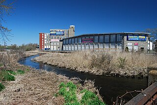
1865 Locustville Mill
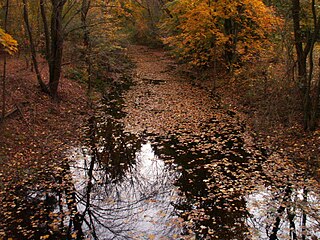
The area known as Locustville is today a section of the village of Hope Valley in the town of Hopkinton, Rhode Island, United States.
This article needs additional citations for verification .(January 2021) |
The area known as Locustville is today a section of the village of Hope Valley in the town of Hopkinton, Rhode Island, United States.
Once a separate village, it was virtually "taken over" by Hope Valley, its more dominant neighbor to the south. Locustville is still a known place, and its past can still be seen in the present day. An example is Locustville Road, a small road near the center of the village, and Locustville Pond, a large pond that stretches through much of the present-day borders of the village of Hope Valley. [1]
The site of Locustville is near the Hope Valley Elementary School on Thelma Drive, of which Locustville Road is an offshoot.
Although the areas which were once Locustville are now known as Hope Valley, the name "Locustville" still is a familiar name among residents, and some residents still identify themselves with the village. [2]

Keston is a village in Greater London, England, located within the London Borough of Bromley, Greater London. Prior to 1965 it was within the historic county of Kent. It is part suburban, part rural in nature and lies on the edge of Hayes Common, just beyond the London conurbation to the south of Bromley Common. It includes the small hamlet of Nash to the southwest. The northern, more suburban part of Keston is sometimes referred to as Keston Mark.

Hope Valley is a village and census-designated place (CDP) in the town of Hopkinton, Rhode Island, United States. The population of the CDP was 1,612 at the 2010 census. Hope Valley is the largest village in Hopkinton, and the town's principal commercial center. While the village of Hope Valley is located in Hopkinton, its ZIP Code, 02832, extends into the neighboring town of Richmond.
Hopkinton is a town in Washington County, Rhode Island. The population was 8,398 at the 2020 census.

Bamford is a village in the Peak District, Derbyshire, England, close to the River Derwent. To the north-east is Bamford Edge, and to the north-west the Ladybower, Derwent and Howden Reservoirs. At the 2011 census, it had a population of 1,241.

The River Rivelin is a river in Sheffield, South Yorkshire, England.

Palmerstown is a civil parish and suburb in western Dublin on the banks of the River Liffey. It forms part of the South Dublin local authority and the Dublin Mid-West parliamentary constituency. The area is bordered to the north by the River Liffey and the Strawberry Beds, to the west by Lucan, to the south-west by Clondalkin, to the south by Ballyfermot and to the east by the village of Chapelizod. Palmerstown village is situated near the Liffey Valley Shopping Centre. The area is situated near the major junction of the M50 motorway and the N4. It lies approximately 7 km west of O'Connell Street in Dublin city centre. The Old Lucan Road, once the main route from the city to the west, passes through the centre of Palmerstown village.

South Attleboro is a village of Attleboro, a city in Bristol County, Massachusetts, United States. It was formerly known as SouthGate, and has its own telephone exchange separate from Attleboro. It is perhaps best known for the South Attleboro station on the Providence/Stoughton Line of the MBTA Commuter Rail. U.S. 1 and Route 1A pass through the area, which lies just north of the Rhode Island state line.

The River Garnock, the smallest of Ayrshire's six principal rivers, has its source on the southerly side of the Hill of Stake in the heart of the Clyde Muirshiel Regional Park. About a mile and a half south of this starting point the untested stream tumbles over the Spout of Garnock, the highest waterfall in Ayrshire, once thought to be the river's origin. The river then continues, for a total length of 20 miles (32 km) or so, through the towns of Kilbirnie, Glengarnock, Dalry and Kilwinning to its confluence with the River Irvine at Irvine Harbour.
Reddish Vale is in the Tame Valley close to Reddish, Greater Manchester, England. The centre of the vale is around the bottom of Reddish Vale Road. Reddish Vale Country Park is a country park managed by Stockport Metropolitan Borough Council (SMBC). It covers 161 hectares in all and comprises some of the traditional Reddish Vale area, Reddish Vale Farm and the grazing land and Woodhall Fields, about 0.5 miles (0.80 km) to the south. Part of it is a designated local nature reserve.
The Quequechan River is a river in Fall River, Massachusetts, that flows in a northwesterly direction from the northwest corner of the South Watuppa Pond through the heart of the city of Fall River and into the end of the Taunton River at Mount Hope Bay at Heritage State Park/Battleship Cove. The word Quequechan means "Falling River" or "Leaping/Falling Waters" in Wampanoag, hence the city's name.
Loose is a village some 2 miles (3 km) south of Maidstone, Kent, situated at the head of the Loose Valley, with which it forms the Loose Valley Conservation Area. The fast- flowing River Loose which rises near Langley runs through the centre of the village and once supported a paper-making industry, evidence of which can still be found. An area round the village is also known as Loose, but Loose village itself is based in the Loose valley and extends along Busbridge Road towards Tovil. The name is believed to be taken from the Loose Stream, which "loses" itself for several miles underground from the point where it rises in Langley.

The Wood River is a river in the U.S. states of Connecticut and Rhode Island. It flows approximately 25 miles (40 km) and is a major tributary of the Pawcatuck River. There are eight dams along the river's length.

Holymoorside is a village in the civil parish of Holymoorside and Walton, in the North East Derbyshire district, in the county of Derbyshire, England, approximately two miles west of Chesterfield. It is located at 53.21 North, -1.49 West. Close to the boundary of the Peak District National Park, Chatsworth House lies seven miles to the west of the village. In 2020 it had an estimated population of 1,419.
Hartford is a neighborhood located along the western edge of Providence, Rhode Island. Route 6 and the Woonasquatucket River separates it from Olneyville.
Primrose is a village in North Smithfield, Rhode Island, United States. The village is located in the area around Greenville Road and Providence Pike. The village takes its name from the Primrose railroad station which existed on Greenville Road for the Providence and Springfield Railroad which began service in 1873. The Primrose Fire Department and North Smithfield High School are located in the area. The historic Primrose Grange (1887) building is located on Grange Road as well as several eighteenth-century farms surrounded by stonewalls.
Redditch is a town and local government district in Worcestershire, England. The town is divided into separate districts. All street-name signs in Redditch have the street name in white lettering on a blue background and the district name in black lettering on a white background at the bottom of the sign. In the New Town areas, the roads are usually named in alphabetical order and house numbering in the cul-de-sac closes is consecutive, starting with number 1.
Vine Brook is a brook in Middlesex County, Massachusetts. According to the History of Bedford, Vine Brook is "an important tributary of Shawsheen River." The book also states it as an excellent source of water-power in the 17th to 19th Centuries.
Whaley's Hollow is a village in Coventry, Rhode Island.
Centerville and Moscow are two rural adjacent villages in the town of Hopkinton, Rhode Island, United States. Located just outside the village of Hope Valley, the two villages are very small and are only separated by Moscow Pond, a small pond in the Rockville Management Area in the northern section of town. Sometimes referred to as "Centerville-Moscow", the area is located on and around Rhode Island Route 138, known as Spring Street, between the villages of Hope Valley and Rockville.
According to the 2010 census, Hope Valley has grown to 1,612 in population and now envelops Locustville, once a separate village. The Locustville mill, also reduced in size after a fire, closed its textile business in 1936 and now houses URE Outfitters.
Municipalities and communities of Washington County, Rhode Island, United States | ||
|---|---|---|
| Towns |  | |
| CDPs | ||
| Other villages | ||
| Indian reservation | ||
41°30′37″N71°42′44″W / 41.51028°N 71.71222°W
| | This Rhode Island state location article is a stub. You can help Wikipedia by expanding it. |