Lumbaca-Unayan, Lanao del Sur

Last updated
Lumbaca-Unayan
Municipality
Municipality of Lumbaca-Unayan
Ph locator lanao del sur lumbaca-unayan.png
Map of Lanao del Sur with Lumbaca-Unayan highlighted
Philippines location map (square).svg
Red pog.svg
Lumbaca-Unayan
Location within the Philippines
Coordinates: 7°46′N124°15′E / 7.77°N 124.25°E / 7.77; 124.25 Coordinates: 7°46′N124°15′E / 7.77°N 124.25°E / 7.77; 124.25
Country Flag of the Philippines.svg  Philippines
Region Autonomous Region in Muslim Mindanao (ARMM)
Province Lanao del Sur
District 2nd District
Founded November 27, 2004
Barangays 9 (see Barangays)
Government [1]
  Type Sangguniang Bayan
   Mayor Somerado Guro
   Vice Mayor Jamalia Dimatunday-Aloyodan
  Electorate 5,583 voters (2016)
Area [2]
  Total 42.28 km2 (16.32 sq mi)
Population (2015 census) [3]
  Total 7,260
  Density 170/km2 (440/sq mi)
Time zone PST (UTC+8)
ZIP code 9707
PSGC 153641000
IDD : area code +63(0)63
Climate type tropical climate

Lumbaca-Unayan, officially the Municipality of Lumbaca-Unayan, is a class municipality in the province of Lanao del Sur, Philippines. According to the 2015 census, it has a population of 7,260 people. [3]

Lanao del Sur Province in Bangsamoro Autonomous Region in Muslim Mindanao, Philippines

Lanao del Sur, officially the Province of Lanao del Sur, is a province in the Philippines located in the Bangsamoro Autonomous Region in Muslim Mindanao (BARMM). The capital is the city of Marawi, and it borders Lanao del Norte to the north, Bukidnon to the east, and Maguindanao and Cotabato to the south. To the southwest lies Illana Bay, an arm of the Moro Gulf.

Philippines Republic in Southeast Asia

The Philippines, officially the Republic of the Philippines, is an archipelagic country in Southeast Asia. Situated in the western Pacific Ocean, it consists of about 7,641 islands that are categorized broadly under three main geographical divisions from north to south: Luzon, Visayas, and Mindanao. The capital city of the Philippines is Manila and the most populous city is Quezon City, both part of Metro Manila. Bounded by the South China Sea on the west, the Philippine Sea on the east and the Celebes Sea on the southwest, the Philippines shares maritime borders with Taiwan to the north, Vietnam to the west, Palau to the east, and Malaysia and Indonesia to the south.

Contents

Through the Muslim Mindanao Autonomy Act No. 106, signed by Nur Misuari on November 22, 2000, the new municipality was created from Lumbatan. A positive affirmation was given in a plebiscite on November 27, 2004.
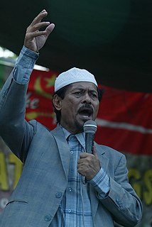
Nur Misuari Filipino politician

Nur Misuari is a Moro revolutionary and politician, founder and leader of the Moro National Liberation Front.

Barangays

Lumbaca-Unayan is politically subdivided into 9 barangays.

Barangay administrative division in the Philippines

A barangay or baranggay (, formerly referred to as barrio, is the smallest administrative division in the Philippines and is the native Filipino term for a village, district or ward. In metropolitan areas, the term often refers to an inner city neighbourhood, a suburb or a suburban neighborhood. The word barangay originated from balangay, a kind of boat used by a group of Austronesian peoples when they migrated to the Philippines.

History

In 2004, nine barangays of Pat ka Apo sa Macadar in Lumbatan were made into Lumbaca-Unayan, a separate municipality among nine Princess of Unayan (e.g.in Meranau terms: 1. Andong sa Macadar 2. Ungklan sa Bita,3. Sana Lumbayanague, 4. Uyoda sa Madamba, 5. Inoda sa Ganassi, 6. Ayor sa Linindingan, 7. inkini sa Tubaran, 8.Togon sa Kadinguilan, 9. Dadauba sa Biabi 10. BOrowa Pagayawan).

Maranao language Austronesian language spoken in the Philippines

Maranao is an Austronesian language spoken by the Maranao people in the provinces of Lanao del Norte and Lanao del Sur in the Philippines, and in Sabah, Malaysia.

Demographics

Population census of
Lumbaca-Unayan
YearPop.±% p.a.
2007 11,766    
2010 6,279−20.43%
2015 7,260+2.80%
Source: Philippine Statistics Authority [3] [4] [5] [6]

Related Research Articles

Ganassi, Lanao del Sur Municipality in Bangsamoro Autonomous Region in Muslim Mindanao, Philippines

Ganassi, officially the Municipality of Ganassi, is a 4th class municipality in the province of Lanao del Sur, Philippines. According to the 2015 census, it has a population of 23,016 people.

Bacolod-Kalawi Municipality in Bangsamoro Autonomous Region in Muslim Mindanao, Philippines

Bacolod-Kalawi, officially the Municipality of Bacolod-Kalawi, is a 3rd class municipality in the province of Lanao del Sur, Philippines. According to the 2015 census, it has a population of 20,841 people.

Balabagan Municipality in Bangsamoro Autonomous Region in Muslim Mindanao, Philippines

Balabagan, officially the Municipality of Balabagan, is a 4th class municipality in the province of Lanao del Sur, Philippines. According to the 2015 census, it has a population of 26,819 people.

Buadiposo-Buntong Municipality in Bangsamoro Autonomous Region in Muslim Mindanao, Philippines

Buadiposo-Buntong, officially the Municipality of Buadiposo-Buntong, is a 4th class municipality in the province of Lanao del Sur, Philippines. According to the 2015 census, it has a population of 16,130 people.

Bubong, Lanao del Sur Municipality in Bangsamoro Autonomous Region in Muslim Mindanao, Philippines

Bubong, officially the Municipality of Bubong, is a 2nd class municipality in the province of Lanao del Sur, Philippines. According to the 2015 census, it has a population of 22,336 people.

Ditsaan-Ramain Municipality in Bangsamoro Autonomous Region in Muslim Mindanao, Philippines

Ditsaan-Ramain, officially the Municipality of Ditsaan-Ramain, is a 3rd class municipality in the province of Lanao del Sur, Philippines. According to the 2015 census, it has a population of 22,299 people.

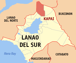
Kapai Municipality in Bangsamoro Autonomous Region in Muslim Mindanao, Philippines

Kapai, officially the Municipality of Kapai, is a 4th class municipality in the province of Lanao del Sur, Philippines. According to the 2015 census, it has a population of 18,894 people.

Lumbayanague Municipality in Bangsamoro Autonomous Region in Muslim Mindanao, Philippines

Lumbayanague, officially the Municipality of Lumbayanague, is a 4th class municipality in the province of Lanao del Sur, Philippines. According to the 2015 census, it has a population of 16,372 people.

Madalum Municipality in Bangsamoro Autonomous Region in Muslim Mindanao, Philippines

Madalum, officially the Municipality of Madalum, is a 3rd class municipality in the province of Lanao del Sur, Philippines. According to the 2015 census, it has a population of 23,127 people.

Madamba Municipality in Bangsamoro Autonomous Region in Muslim Mindanao, Philippines

Madamba, officially the Municipality of Madamba, is a 4th class municipality in the province of Lanao del Sur, Philippines. According to the 2015 census, it has a population of 17,756 people.

Maguing Municipality in Bangsamoro Autonomous Region in Muslim Mindanao, Philippines

Maguing, officially the Municipality of Maguing, is a 2nd class municipality in the province of Lanao del Sur, Philippines. According to the 2015 census, it has a population of 24,531 people.

Marantao Municipality in Bangsamoro Autonomous Region in Muslim Mindanao, Philippines

Marantao, officially the Municipality of Marantao, is a 2nd class municipality in the province of Lanao del Sur, Philippines. According to the 2015 census, it has a population of 32,974 people.

Masiu Municipality in Bangsamoro Autonomous Region in Muslim Mindanao, Philippines

Masiu, officially the Municipality of Masiu, is a 5th class municipality in the province of Lanao del Sur, Philippines. According to the 2015 census, it has a population of 29,176 people.

Mulondo, Lanao del Sur Municipality in Bangsamoro Autonomous Region in Muslim Mindanao, Philippines

Mulondo, officially the Municipality of Mulondo, is a 3rd class municipality in the province of Lanao del Sur, Philippines. According to the 2015 census, it has a population of 16,067 people.

Pagayawan Municipality in Bangsamoro Autonomous Region in Muslim Mindanao, Philippines

Pagayawan, officially the Municipality of Pagayawan, is a 5th class municipality in the province of Lanao del Sur, Philippines. According to the 2015 census, it has a population of 13,139 people.

Poona Bayabao Municipality in Bangsamoro Autonomous Region in Muslim Mindanao, Philippines

Poona Bayabao, officially the Municipality of Poona Bayabao, is a 4th class municipality in the province of Lanao del Sur, Philippines. According to the 2015 census, it has a population of 22,227 people.

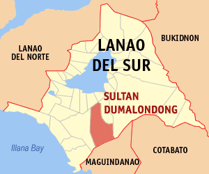
Sultan Dumalondong Municipality in Bangsamoro Autonomous Region in Muslim Mindanao, Philippines

Sultan Dumalondong, officially the Municipality of Sultan Dumalondong, is a 6th class municipality in the province of Lanao del Sur, Philippines. According to the 2015 census, it has a population of 11,298 people.

Tamparan Municipality in Bangsamoro Autonomous Region in Muslim Mindanao, Philippines

Tamparan, officially the Municipality of Tamparan, is a 5th class municipality in the province of Lanao del Sur, Philippines. According to the 2015 census, it has a population of 25,874 people.

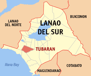
Tubaran Municipality in Bangsamoro Autonomous Region in Muslim Mindanao, Philippines

Tubaran, officially the Municipality of Tubaran, is a 4th class municipality in the province of Lanao del Sur, Philippines. According to the 2015 census, it has a population of 14,749 people.

References

  1. "Municipality". Quezon City, Philippines: Department of the Interior and Local Government. Retrieved 31 May 2013.
  2. "Province: Lanao del Sur". PSGC Interactive. Quezon City, Philippines: Philippine Statistics Authority . Retrieved 12 November 2016.
  3. 1 2 3 Census of Population (2015). "ARMM – Autonomous Region in Muslim Mindanao". Total Population by Province, City, Municipality and Barangay. PSA . Retrieved 20 June 2016.
  4. Census of Population and Housing (2010). "ARMM – Autonomous Region in Muslim Mindanao". Total Population by Province, City, Municipality and Barangay. NSO . Retrieved 29 June 2016.
  5. Censuses of Population (1903–2007). "ARMM – Autonomous Region in Muslim Mindanao". Table 1. Population Enumerated in Various Censuses by Province/Highly Urbanized City: 1903 to 2007. NSO.
  6. "Province of Lanao del Sur". Municipality Population Data. Local Water Utilities Administration Research Division. Retrieved 17 December 2016.