
The East Blackstone Village Historic District is a historic district roughly along Elm Street at the junction with Summer Street in eastern Blackstone, Massachusetts. It encompasses a small 19th-century mill village center that developed along what was once a major roadway connecting Worcester with Providence, Rhode Island. The district was added to the National Register of Historic Places in 1995.
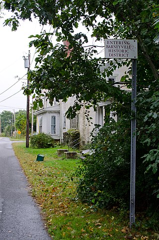
The Barneyville Historic District is a predominantly residential historic district on Old Providence and Barneyville Roads in northwestern Swansea, Massachusetts. The area was the site of a successful shipbuilding operation during the early 19th century, and then became a local center for jewelry making. The district was added to the National Register of Historic Places in 1990.

The Luther Store is a historic store at 160 Old Warren Road in Swansea, Massachusetts. It is a 2+1⁄2-story brick structure with a saltbox profile. Its main facade is five bays wide, with entrances in the second and fourth bays, and interior chimneys at each end. The store retains original fixtures, including solid mahogany counters, drawers for goods storage, and the proprietor's desk. The store was built in 1815 by John Brown Luther, and was operated by the Luther family as a store until 1903. The Luther's Corner area was in the mid-19th century the economic center of Swansea, and Luther's Store served as post office and library. It was acquired in 1941 by the Swansea Historical Society, which now operates it as a local history museum.

The Benjamin Cole House is a historic house in Swansea, Massachusetts, United States. Built in 1690, this house is the oldest documented building in Swansea.

Hortonville is a village in the town of Swansea, Bristol County, Massachusetts, United States. The part of the village on Locust Street from Oak Street to Hortonville Road comprises the Hortonville Historic District, which was listed on the National Register of Historic Places in 1990.

The Spencer Town Center Historic District encompasses the historic downtown of Spencer, Massachusetts. When first listed on the National Register of Historic Places in 1986, the district covered 250 acres (100 ha) centered on Main Street between High and North Streets. A major expansion, the East Main Street – Cherry Street Historic District, added 45 acres (18 ha) of a predominantly residential area east of the center. The district was expanded twice in 2003, adding residential areas along Grove, Prouty, Pleasant, High, and Main Streets, and industrial areas on Cherry, Wall, and Mechanic Streets, as well as Luther Hill Park. The main period of historic interest is the peak period of Spencer's industrial history in the last quarter of the 19th century, although there are a significant number of properties that predate this period.

The Five Corners Historic District is a historic district encompassing the central district of the village of South Williamstown, Massachusetts. It is centered at the junction of Cold Spring, Green River, New Ashford. The junction has been a prominent center in the area since 1760. Prominent buildings in the district include the South Center School, the Store at Five Corners, and the Second Congregational Church. The district was listed on the National Register of Historic Places in 1993.

The South Egremont Village Historic District encompasses most of the village of South Egremont, Massachusetts, a well-preserved village whose architecture has seen relatively little alteration since the 1840s. It is located along Massachusetts Route 23 in the plains east of the Taconic Mountains. The district was listed on the National Register of Historic Places in 1984.

The Russell Center Historic District is a historic district encompassing the historic village center of Russell, Massachusetts. It is centered at the junction of Main Street and Lincoln Avenue, and is bordered by the Westfield River to the east, and the rising foothills of The Berkshires to the west. The village's 19th century development was spurred by the railroad and sustained by local papermaking businesses. It was listed on the National Register of Historic Places in 1996, and was named as one of the 1,000 places to visit in Massachusetts by the Great Places in Massachusetts Commission.

The Granville Village Historic District is a historic district encompassing the historic Granville Village area in eastern Granville, Massachusetts. The area was developed in the 19th century as an industrial village, centered on the drum factory of Noble & Cooley on Dickinson Brook. The predominantly residential district includes a number of Greek Revival houses; it also includes the Colonial Revival public library building. It is located roughly in the area around the junction of Maple St. and Main and Granby Rds., including part of Water Street. The district was listed on the National Register of Historic Places in 1991.

The Taftsville Historic District encompasses a historic 19th-century industrial village that is mostly in Woodstock, Vermont. Flanking the Ottauquechee River and extending up Happy Valley Road, the area developed around a metal tool factory established by members of the Taft family in 1793. Important elements from its early history include the Taftsville Store, built by the Taft family in 1840, and the Taftsville Covered Bridge, built in 1836. The district was listed on the National Register of Historic Places in 2001.

The Monson Center Historic District is a historic district encompassing the historic 19th century economic and civic heart of Monson, Massachusetts, a small town in eastern Hampden County. The district was listed on the National Register of Historic Places in 1991.

The Haverhill Corner Historic District encompasses the early civic center of Haverhill, New Hampshire, United States. The district is focused on the junction of New Hampshire Route 10 and Court Street, which was historically a major through route. Court Street is flanked at the junction by a pair of large grassy common areas which are bounded by School Street and Route 10. Buildings, predominantly Federal in character and built in the late 18th and early 19th centuries, are arrayed around these commons, and historic buildings line Route 10 and Court Street for a short distance away from the commons. Prominent buildings in the district include the 1827 Federal-style First Congregational Church, the 1840 former courthouse that now houses the public library and local historical society, and the Romanesque Revival 1897 Haverhill Academy Junior High School building. The area declined in importance after the railroad bypassed it, resulting in the gradual relocation of civic functions to the Woodsville area. The district was listed on the National Register of Historic Places in 1987.

The Lower Corner Historic District encompasses a small village center in the town of Sandwich, New Hampshire. Lower Corner is a rural village that is strung along New Hampshire Route 109 on either side of its junction with School House Road, about one mile from the main village of Center Sandwich. The village was developed relatively early in Sandwich's history, although its oldest buildings now date to the early 19th century. There are 25 contributing structures, mostly residences. There are two buildings built as stores, including one of brick; all the other buildings are wood frame. The district was listed on the National Register of Historic Places in 1986.

The Smith's Corner Historic District is a historic district encompassing a historic 19th-century rural village center. Covering about 105.5 acres (42.7 ha), the district is centered on the junction of Main Avenue, South Road, and Chase Road in northwestern South Hampton, abutting its border with East Kingston. The village was important as a stagecoach stop. The district was listed on the National Register of Historic Places in 1983.

The Danby Village Historic District encompasses much of the town center of Danby, Vermont. It is centered on a stretch of Main Street, roughly between Depot Street and Brook Road. The village has a cohesive collection of mid-19th century architecture, mostly residential, with a modest number of later additions. The district was listed on the National Register of Historic Places in 1983.
The Middletown Springs Historic District encompasses most of the village center of Middletown Springs, Vermont. Oriented around the crossroads junction of Vermont Routes 140 and 133, the village has a well-preserved collection of mainly mid-19th century architecture, including a significant number of Italianate buildings. The district was listed on the National Register of Historic Places in 1985.
The Charlotte Center Historic District encompasses the historic 19th-century town center of Charlotte, Vermont. Settled c. 1790 and developed mainly in the mid-19th century, the village, stretched along Church Hill Road west of Hinesburg Road, retains a well-preserved 19th-century atmosphere of residential, civic, and commercial buildings. The district was listed on the National Register of Historic Places in 1984.

The Waitsfield Village Historic District encompasses much of the main village center of Waitsfield, Vermont. Extending along Vermont Route 100 on either side of Bridge Street, it is a well-preserved example of a 19th-century village, with only a few sympathetic 20th-century additions. It was listed on the National Register of Historic Places in 1983.

The Peacham Corner Historic District encompasses much of the historic village center of Peacham, Vermont. The village's period of greatest growth and importance between the town's founding as a hill town in the late 18th century, and 1860, when significant development effectively ended. As a result, the village lacks Victorian features often found in other rural communities. The district was listed on the National Register of Historic Places in 2003.


