Dealey Plaza is a city park in the West End Historic District of downtown Dallas, Texas. It is sometimes called the "birthplace of Dallas". It was also the location of the assassination of John F. Kennedy in 1963. Thirty minutes after the shooting, Kennedy was pronounced dead at Parkland Memorial Hospital. The Dealey Plaza Historic District was named a National Historic Landmark on the 30th anniversary of the assassination, to preserve Dealey Plaza, street rights-of-way, buildings, and structures by the plaza visible from the assassination site, that have been identified as witness locations or as possible locations for the assassin.

Downtown is the largest central business district in the city of Houston and the largest in the state of Texas, located near the geographic center of the metropolitan area at the confluence of Interstate 10, Interstate 45, and Interstate 69. The 1.84-square-mile (4.8 km2) district, enclosed by the aforementioned highways, contains the original townsite of Houston at the confluence of Buffalo Bayou and White Oak Bayou, a point known as Allen's Landing. Downtown has been the city's preeminent commercial district since its founding in 1836.
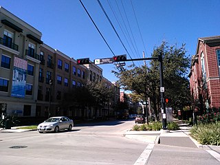
Midtown is a central neighborhood of Houston, located west-southwest of Downtown. Separated from Downtown by an elevated section of Interstate 45, Midtown is characterized by a continuation of Downtown's square grid street plan, anchored by Main Street and the METRORail Red Line. Midtown is bordered by Neartown (Montrose) to the west, the Museum District to the south, and Interstate 69 to the east. Midtown's 325 blocks cover 1.24 square miles (3.2 km2) and contained an estimated population of nearly 8,600 in 2015.

The University of Houston–Downtown (UHD) is a public university in Houston, Texas. Established in 1974 as University of Houston–Downtown College (UH–DC), it has a campus that spans 40 acres (0.16 km2) in Downtown Houston with a satellite location, UHD–Northwest, inside Lone Star College–University Park. The university is one of four institutions in the University of Houston System.

The West End Historic District of Dallas, Texas, is a historic district that includes a 67.5-acre (27.3 ha) area in northwest downtown, generally north of Commerce, east of I-35E, west of Lamar and south of the Woodall Rodgers Freeway. It is south of Victory Park, west of the Arts, City Center, and Main Street districts, and north of the Government and Reunion districts. A portion of the district is listed on the U.S. National Register of Historic Places as Westend Historic District. A smaller area is also a Dallas Landmark District. The far western part of the district belongs to the Dealey Plaza Historic District, a National Historic Landmark around structures and memorials associated with the assassination of John F. Kennedy.

UH–Downtown is a station on the METRORail Red Line in Houston, Texas, United States. It is the former northern terminus of the Red Line, since the line was extended in late 2013. The station is located on top of the Main Street viaduct at the campus of the University of Houston–Downtown.

Allen's Landing is the officially recognized birthplace of the city of Houston, Texas, United States, the largest city in Texas and the fourth largest in the United States. Located in Downtown Houston between the Main Street and Fannin Street viaducts, the landing encompasses the southern bank of Buffalo Bayou, the city's principal river, at its confluence with White Oak Bayou, a major tributary. Allen's Landing is located south of the University of Houston–Downtown Commerce Street Building.
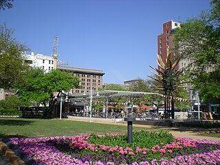
Market Square Park is a public park in Downtown Houston, Texas, United States. Originally set aside by the Houston Town Company as "Congress Square," the public square was used as a marketplace and city hall, which assumed the name, "Market Square." The City of Houston constructed four different market house/city halls, the first of which opened in 1840. The fourth was constructed in 1904. Market Square is a central feature of the Main Street/Market Square Historic District, a historic district listed on the National Register of Historic Places. The square is surrounded by a combination of nineteenth-century architecture and modern residential towers, with ground leases housing a variety of restaurants and bars.

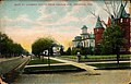
The Dallas County Courthouse, built in 1892 of red sandstone with rusticated marble accents, is a historic governmental building located at 100 South Houston Street in Dallas, Texas. Also known as the Old Red Courthouse, it became the Old Red Museum, a local history museum, in 2007. In 2021, it was announced that the Old Red Museum would be moving out and the building is being returned into a hall of justice. The Texas Fifth Circuit Court of Appeals is moving into Old Red (2024).

The Dr. Nathan and Lula Cass House, also known as the Magnolia House, is a historic octagon house located at 502 N. Travis Avenue in Cameron, Texas, United States. On February 8, 1991, it was added to the National Register of Historic Places. Built in 1885, it was known as the Magnolia Inn until being purchased by a private party in 2018.
919 Milam is a building in Downtown Houston, Texas completed in 1956. The building has been previously named 909 Travis, Bank One Center, and the Bank of the Southwest Building. The building occupies the entire block bounded by Milam, McKinney, Travis, and Walker streets. Ownership of the building has changed hands several times over the last twenty years.

Gay Street is a street in Knoxville, Tennessee, United States, that traverses the heart of the city's downtown area. Since its development in the 1790s, Gay Street has served as the city's principal financial and commercial thoroughfare, and has played a primary role in the city's historical and cultural development. The street contains Knoxville's largest office buildings and oldest commercial structures. Several buildings on Gay Street have been listed on the National Register of Historic Places.

George M. Coombs was an American architect in practice in Lewiston, Maine from 1874 to 1909.

Travis County has had two locations named Montopolis. The first was during the Republic of Texas period north of the Colorado River. The second is today's Montopolis neighborhood in Austin, Texas south of the river. Located southeast of the city's urban core, today's neighborhood is in ZIP code 78741. Montopolis is bounded by Lake Lady Bird on the north, by Grove Street and the Pleasant Valley neighborhood on the west, to the south by Texas State Highway 71, and by U.S. Route 183 on the east. The southeast corner abuts Austin-Bergstrom International Airport. Montopolis is in City Council District 3.

The Cotton Exchange Building is a historic building located in Downtown Houston.
Eugene Thomas Heiner was an American architect who designed numerous courthouses, county jails, and other public buildings in Texas. He was born in New York City, apprenticed in Chicago, and studied further in Germany. His works includes buildings listed on the U.S. National Register of Historic Places.

The Humble Oil Building, is a historic office building, designed in the Italian Renaissance architecture style, located at 1212 Main Street in Houston, Texas and listed on the National Register of Historic Places. It was constructed by Humble Oil and Refining Company in 1921. The tower section was added on to the building in 1936. The building complex served as the company headquarters for Humble Oil and Refining Company from 1921 until 1963, when the company moved into what is now the ExxonMobil Building at 800 Bell Street. In 2003, the building complex was renovated for use as a combination hotel and apartments, the apartment section was converted to additional hotel rooms in 2015.
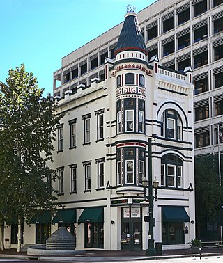
The Sweeney, Coombs, and Fredericks Building is a late Victorian commercial building with a 3-story corner turret and Eastlake decorative elements that was designed by George E. Dickey in 1889. The building is located at 301 Main Street in Houston, Texas and occupies the corner of Main Street and Congress Street in Downtown Houston. The building is one of the few Victorian-style architectural structures that remains in the city. The building received a "City of Houston Landmark" designation in 2009. The building is included in the National Register of Historic Places by virtue of being a conforming structure in the Main Street/Market Square Historic District.
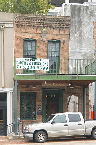
Kennedy Bakery, located at 813 Congress Street in Houston, Texas, was listed on the National Register of Historic Places on July 27, 1979. The historic property in downtown Houston faces Market Square and lies within the Main Street Market Square Historic District. It is probably the "oldest Houston building existing on its original site."

William B. Travis Elementary School is a public elementary school in the Woodland Heights area of Houston, Texas. It is a part of the Houston Independent School District (HISD).