Marcus Hook Range Rear Light

Last updated
Marcus Hook Range Rear Light
Marcus Range Rear Range Light (42683102761).jpg
Lightouse viewed from shore.
Marcus Hook Range Rear Light
LocationJust South of Bellefonte, Delaware
Coordinates 39°45′44.2″N75°30′11.3″W / 39.762278°N 75.503139°W / 39.762278; -75.503139
Tower
Constructed1915  OOjs UI icon edit-ltr-progressive.svg
Foundation Concrete
Construction Reinforced concrete
Automated1950s
Height105 feet (32 m)
ShapeSquare
HeritageNational Register of Historic Places listed place  OOjs UI icon edit-ltr-progressive.svg
Light
First lit1920
Focal height278 feet (85 m)
LensFourth order Fresnel lens (original), RL-24 (current)
Characteristic Fixed red (initially fixed white)
Marcus Hook Range Rear Light
Architectural style Colonial Revival
NRHP reference No. 89000287 [1] [2]
Added to NRHPMarch 27, 1989

Marcus Hook Range Rear Light is a lighthouse near Bellefonte, Delaware marking a range on the Delaware River. [3] It is the highest light on the Atlantic coast of the United States. [4] The lighthouse is visible on the horizon from the windows of high-rise buildings in downtown Wilmington, Delaware. [5]

Contents

History

The permanent structure was preceded by a temporary light on a post, erected in 1915. [4] The present tower was built in 1918 and was composed of nine sections of reinforced concrete; there is also an oil house and a keeper's dwelling on the site. The original beacon displayed a fixed white light using a Fourth order Fresnel lens; this was removed in the early 1980s and replaced with a RL-24 beacon, displaying a fixed red indication. The light was automated in the 1950s, but the keeper's house was occupied by Coast Guard personnel until 2004. [6] [7]

In March 2005 the lighthouse became available for transfer under the National Historic Lighthouse Preservation Act, but in 2010 a private owner bought the lighthouse and the accompanying home on the property. The tower is an active aid to navigation and not open to the public.

Front Light

The Marcus Hook Range Front Light stood about 100 yards (91 m) offshore, 1.6 miles (2.6 km) to the northeast of Marcus Hook Range Rear Light. [4] Its tower was erected in 1925 and was preceded by a temporary light tower erected in 1915. [4] It has always been automated. [8]

Replacement range

In June 2019, a new rear range light was erected approximately where the front range light was, and a new front range light was erected upstream. The (old) rear range light was turned off. [9]

Related Research Articles

<span class="mw-page-title-main">Pensacola Light</span> Lighthouse in Florida, US

The Pensacola Light is a lighthouse at Pensacola Bay, in Florida. It is the third iteration of what was originally a lightship, the Aurora Borealis, and remains an aid to navigation.

<span class="mw-page-title-main">Delaware Breakwater East End Light</span> Lighthouse

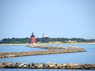
The Delaware Breakwater East End Light is a lighthouse located on the inner Delaware Breakwater in the Delaware Bay, just off the coast of Cape Henlopen and the town of Lewes, Delaware.

<span class="mw-page-title-main">Saginaw River Rear Range Light</span> Lighthouse in Michigan, United States

The first Saginaw River lighthouse was constructed from 1839 to 1841, in a period when large quantities of lumber were being harvested and shipped from the heart of Michigan via river and the Great Lakes to the East Coast of the United States via the Erie Canal and Hudson River. This connection to major eastern markets was critical to the development of central Michigan.

<span class="mw-page-title-main">Bellevue Range Rear Light</span> Lighthouse

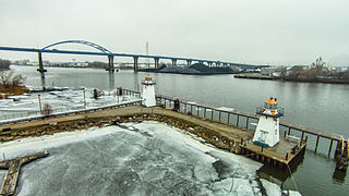
Bellevue Range Rear Lighthouse is a lighthouse in Delaware, United States, on the mouth of the Christina River on the Delaware River, Wilmington, Delaware

<span class="mw-page-title-main">Reedy Island Range Rear Light</span> Lighthouse

Reedy Island Range Rear Lighthouse is a skeletal tower lighthouse near Taylor's Bridge, Delaware. The tower is an active aid to navigation.

<span class="mw-page-title-main">Craighill Channel Lower Range Front Light</span> Lighthouse in Maryland, United States

The Craighill Channel Lower Range Front Light, named for William Price Craighill, was the first caisson lighthouse built in the Chesapeake Bay in Maryland, USA. First lit in 1873, the range marks the first leg of the maintained Craighill Channel from the Chesapeake Bay at the mouth of the Patapsco River into the Baltimore harbor and works in conjunction with the Craighill Channel Lower Range Rear Light. It was owned by non-profit organization Historical Place Preservation, Inc. from 2005 until the government took back the property in 2017 due to neglect. The lighthouse was put up for auction and sold to the highest bidder on September 15 2017 for $95,000.

<span class="mw-page-title-main">Highland Light</span> Lighthouse

The Highland Light is an active lighthouse on the Cape Cod National Seashore in North Truro, Massachusetts. The current tower was erected in 1857, replacing two earlier towers that had been built in 1797 and 1831. It is the oldest and tallest lighthouse on Cape Cod.

The Hawkins Point Light was an unusual screw-pile lighthouse which displayed the front light to the Brewerton Channel Range. It was eventually superseded by an iron tower on the same foundation.

<span class="mw-page-title-main">Grassy Island Range Lights</span> Lighthouse

The Grassy Island Range Lights are a pair of lighthouses which were originally established to guide traffic through the channel into Green Bay harbor. They were deactivated and moved to shore as part of a channel-widening project.

<span class="mw-page-title-main">Ship John Shoal Light</span> Lighthouse

The Ship John Shoal Light marks the north side of the ship channel in Delaware Bay on the east coast of the United States, near the Bombay Hook National Wildlife Refuge. Its cast iron superstructure was exhibited at the 1876 Centennial Exposition in Philadelphia, Pennsylvania.

<span class="mw-page-title-main">Hospital Point Range Front Light</span> Lighthouse

Hospital Point Range Front Light is a historic lighthouse at the end of Bayview Avenue in Beverly, Massachusetts. It forms the front half of a range which guides vessels toward Salem Harbor. The tower was added to the National Register of Historic Places as Hospital Point Light Station on September 28, 1987.

<span class="mw-page-title-main">Fort Sumter Range Lights</span> Lighthouses in South Carolina, US

The Fort Sumter Range Lights are range lights to guide ships through the main channel of the Charleston Harbor, South Carolina. The original front light was built at Fort Sumter and the original rear light was in the steeple of St. Philip's Church in Charleston, South Carolina. Both lights were lit from 1893 to 1915 to make range lights. Today the Fort Sumter Range is the main approach channel to Charleston Harbor.

<span class="mw-page-title-main">Tinicum Island Rear Range Light</span> Lighthouse

The Tinicum Island Rear Range Light is a lighthouse located in the Billingsport section of Paulsboro in Gloucester County, New Jersey, the rear of a pair of range lights marking a section of the channel in the Delaware River south of Philadelphia.

<span class="mw-page-title-main">Burnt Island Light</span> Lighthouse in Maine, United States

The Burnt Island Light, built in 1821, is the second oldest surviving lighthouse in Maine. It hosts a living history museum run by the state Department of Marine Resources. It was added to the National Register of Historic Places as Burnt Island Light Station on November 23, 1977.

<span class="mw-page-title-main">Green Island Light (Wisconsin)</span> Lighthouse

The Green Island Light is a lighthouse located on Green Island in Green Bay. Abandoned since its deactivation in 1956, it survives as a hollow shell near the existing skeleton tower.

<span class="mw-page-title-main">Rawley Point Light</span> Lighthouse

Rawley Point Light is a lighthouse located in Point Beach State Forest, near Two Rivers, Wisconsin. At 111 feet (34 m) tall, it is the tallest lighthouse on the Wisconsin Shore and it is listed on the National Register of Historic Places.

<span class="mw-page-title-main">Christiana Light</span> Lighthouse

The Christiana Light was a historic lighthouse located on the Christina River in Delaware. It was deactivated when new range lights came into service and was demolished in 1939.

The Delaware Breakwater Range Rear Light was a lighthouse west of Lewes, Delaware. It was made obsolete by the shifting of Cape Henlopen and was disassembled and moved to Florida to become the Boca Grande Entrance Range Rear Light.

References

  1. "National Register Information System". National Register of Historic Places . National Park Service. July 9, 2010.
  2. NRHP Registration form
  3. Rowlett, Russ. "Lighthouses of the United States: Delaware". The Lighthouse Directory. University of North Carolina at Chapel Hill.
  4. 1 2 3 4 "The rear range light of Marcus Hook on the Delaware River, 278 feet above the level of the sea, is the highest light on the Atlantic Coast of the continental United States." Trapani, Bob (2007). Delaware Lights: A History of Lighthouses in the First State. The History Press. p. 138. ISBN   978-1-59629-021-1.[ permanent dead link ]
  5. "Photo of the Marcus Hook Range Rear Light from Wilmington, DE". 4 March 2020.
  6. "Marcus Hook Rear Range, DE". Lighthouse Friends.
  7. DeWire, Elinor (2011). Lighthouses of the Mid-Atlantic Coast: Your Guide to the Lighthouses of New York, New Jersey, Maryland, Delaware, and Virginia. Minneapolis: Voyageur Press. p. 154. ISBN   9780760339510 . Retrieved 2012-10-05.
  8. "Marcus Hook Range Lighthouse".
  9. "Marcus Hook Range Lighthouse".