Port-au-Prince is the capital and most populous city of Haiti. The city's population was estimated at 1,200,000 in 2022 with the metropolitan area estimated at a population of 2,618,894. The metropolitan area is defined by the IHSI as including the communes of Port-au-Prince, Delmas, Cité Soleil, Tabarre, Carrefour, and Pétion-Ville.

Carrefour is a largely residential commune in the Port-au-Prince Arrondissement, in the Ouest department of Haiti. Port-au-Prince has a population of 1,234,742 while the commune has a population of 501,768.

Dessalines usually referred to as Marchand-Dessalines, is a commune in the Artibonite department of Haiti. It is named after Jean-Jacques Dessalines, a leader of the Haitian Revolution and the first ruler and emperor of independent Haiti.

An arrondissement is a level of administrative division in Haiti.
In the administrative divisions of Haiti, the department is the first of four levels of government. Haiti is divided administratively into ten departments, which are further subdivided into 42 arrondissements, 145 communes, and 571 communal sections.

The administrative divisions of Haiti are concerned with the institutional and territorial organization of Haitian territory. There are many administrative divisions which may have political, electoral (districts), or administrative objectives.

Milot is a commune in the Nord department of Haiti, 12 miles south of Cap-Haïtien. It is the site of Sans-Souci Palace, one of Haiti's most revered landmarks. The Citadelle Laferrière, Haiti's best-known landmark, is five miles (8 km) by road to the south. The town also hosts a hospital, Hôpital Sacré Coeur, run by the Sovereign Military Order of Malta and the Crudem Foundation.
Anse-à-Galets is a commune and city in the La Gonâve Arrondissement, in the Ouest department on Gonâve Island in Haiti, located to the west-northwest of Port-au-Prince in the Gulf of Gonâve. It is the largest commune on the island and has 62,559 inhabitants.
Arcahaie is a commune in the Arcahaie Arrondissement, in the Ouest department of Haiti. In 2015, the commune had 130,306 inhabitants.
Cabaret is a commune in the Arcahaie Arrondissement, in the Ouest department of Haiti. In 2009, the commune had 62,063 inhabitants. During his dictatorship, François Duvalier renamed it Duvalierville ; in 1961 a construction project was begun. Construction eventually stopped, but the name was kept until Duvalier's successor, his son Jean-Claude Duvalier, fled the country in 1986.
Beaumont is a commune in the Corail Arrondissement, in the Grand'Anse department of Haiti. It has 31,580 inhabitants in 2015.
Petit-Trou-de-Nippes is a commune in the Anse-à-Veau Arrondissement, in the Nippes department of Haiti. It has 36,143 inhabitants.
Petite-Rivière-de-Nippes is a commune in the Miragoâne Arrondissement, in the Nippes department of Haiti. It has 29,815 inhabitants. Petite-Rivière-de-Nippes is one of the 28 communes in which the Pan American Development Foundation implements the Government of Haiti's Project for Participatory Development (PRODEP).
Acul-du-Nord is a commune in the Acul-du-Nord Arrondissement, in the Nord department of Haiti.
Capotille is a commune in the Ouanaminthe Arrondissement, in the Nord-Est department of Haiti. It has 15,086 inhabitants and is adjacent to the Dominican Republic–Haiti border.
Trou-du-Nord is a commune in the Trou-du-Nord Arrondissement, in the Nord-Est department of Haiti. It has a population of 37,405.
Bainet is a commune in the Bainet Arrondissement, in the Sud-Est department of Haiti. It has 62,300 inhabitants as of 2003.
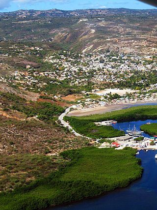
Cayes-Jacmel is a commune in the Jacmel Arrondissement, in the Sud-Est department of Haiti. It has 36693 inhabitants. Cayes-Jacmel is down the road from Cyvadier and home to a lovely public beach and has a remarkable farmers market. The town is also home to amazing artists and artisans, including work in meticulously created miniature ships. The region's hydroelectric plant is nearby.

Port-au-Prince is an arrondissement in the Ouest department of Haiti. It had 2,109,516 inhabitants at the 2003 Census which was estimated to have risen to 2,759,991 in 2015 in an area of 735.78 sq km. Postal codes in the Port-au-Prince Arrondissement start with the number 61.