Columbine is an unincorporated community and a census-designated place (CDP) located in and governed by Jefferson and Arapahoe counties, Colorado, United States. The CDP is a part of the Denver–Aurora–Lakewood, CO Metropolitan Statistical Area. Located primarily in Jefferson County, Columbine lies immediately south of Denver. The population of the Columbine CDP was 24,280 at the United States Census 2010. The community lies in ZIP code 80123.

Acres Green is an unincorporated community and a census-designated place (CDP) located in and governed by Douglas County, Colorado, United States. The CDP is a part of the Denver–Aurora–Lakewood, CO Metropolitan Statistical Area. The population of the Acres Green CDP was 3,007 at the 2010 United States Census. The community lies in ZIP Code 80124.
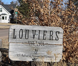
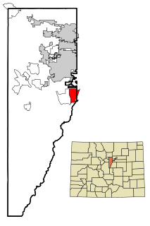
Louviers is an unincorporated town, a post office, and a census-designated place (CDP) located in and governed by Douglas County, Colorado, United States. The CDP is a part of the Denver–Aurora–Lakewood, CO Metropolitan Statistical Area. The Louviers post office has the ZIP Code 80131. At the United States Census 2010, the population of the Louviers CDP was 269, while the population of the 80131 ZIP Code Tabulation Area was 243.

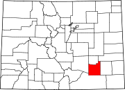
Sedalia is an unincorporated town, a post office, and a census-designated place (CDP) located in and governed by Douglas County, Colorado, United States. The CDP is a part of the Denver–Aurora–Lakewood, CO Metropolitan Statistical Area. The Sedalia post office has the ZIP Code 80135. At the United States Census 2010, the population of the Sedalia CDP was 206, while the population of the 80135 ZIP Code Tabulation Area was 3,833 including adjacent areas.

Edwards is an unincorporated town, a post office, and a census-designated place (CDP) located in and governed by Eagle County, Colorado, United States. Edwards is the principal town of the Edwards, CO Micropolitan Statistical Area. The Edwards post office has the ZIP Code 81632. At the United States Census 2010, the population of the Edwards CDP was 10,266, while the population of the 81632 ZIP Code Tabulation Area was 10,267. The Edwards Metropolitan District provides services.

Kittredge is an unincorporated town, a post office, and a census-designated place (CDP) located in and governed by Jefferson County, Colorado, United States. The CDP is a part of the Denver–Aurora–Lakewood, CO Metropolitan Statistical Area. The Kittredge post office has the ZIP code 80457. At the United States Census 2010, the population of the Kittredge CDP was 1,304, while the population of the 80457 ZIP Code Tabulation Area was 612.

The Town of Lakeside is a Statutory Town in Jefferson County, Colorado, United States. The town population was 8 at the 2010 United States Census, making Lakeside the least populous municipality in the State of Colorado. Lakeside is immediately west of the City and County of Denver, the most populous municipality in the state. The Denver Post Office serves Lakeside.

Sterling is the home rule municipality that is the county seat and the most populous municipality of Logan County, Colorado, United States. Sterling is the principal city of the Sterling, CO Micropolitan Statistical Area. The city population was 14,777 at the 2010 census, making it the largest city in Colorado's eastern plains.

La Junta is the home rule municipality that is the county seat and the most populous municipality of Otero County, Colorado, United States. The city population was 7,322 at the 2020 United States Census. La Junta is located on the Arkansas River in southeastern Colorado 68 miles (109 km) east of Pueblo.

Bailey is an unincorporated community and U.S. Post Office in northeastern Park County, Colorado, United States. Bailey's Post Office ZIP Code is 80421.

Watkins is an unincorporated town and a census-designated place (CDP) located in and governed by Arapahoe and Adams counties, Colorado, United States. The CDP is a part of the Denver–Aurora–Lakewood, CO Metropolitan Statistical Area. The town is surrounded by Aurora and its post office, which lies within the Aurora city limits, has the ZIP Code 80137. At the United States Census 2010, the population of the Watkins CDP was 653, while the population of the 80137 ZIP Code Tabulation Area was 1,323 including adjacent communities.

Bond is an unincorporated community and U.S. Post Office in Eagle County, Colorado, United States. The Bond Post Office has the ZIP Code 80423. Although Bond has never had a sizable population, the town has significant railroad history, and once was a stop for most of the passenger trains along the Denver and Rio Grande Western's main line.

Conejos is an unincorporated town, a post office, a census-designated place (CDP), and the county seat of Conejos County, Colorado, United States. The Conejos post office has the ZIP Code 81129. At the United States Census 2010, the population of the Conejos CDP was 58, while the population of the 81129 ZIP Code Tabulation Area was 156 including adjacent areas. Conejos is the only unincorporated county seat in the State of Colorado.

Hasty is an unincorporated town, a post office, and a census-designated place (CDP) located in and governed by Bent County, Colorado, United States. The Hasty post office has the ZIP code 81044. At the United States Census 2010, the population of the Hasty CDP was 144, while the population of the 81044 ZIP Code Tabulation Area was 224 including adjacent areas.
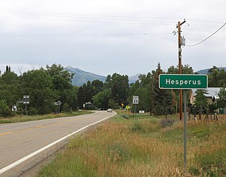
Hesperus is an unincorporated community and a U.S. Post Office located in La Plata County, Colorado, United States. The Hesperus Post Office has the ZIP Code 81326.

Howard is an unincorporated town, a post office, and a census-designated place (CDP) located in and governed by Fremont County, Colorado, United States. The CDP is a part of the Cañon City, CO Micropolitan Statistical Area. The Howard post office has the ZIP Code 81233. At the United States Census 2010, the population of the Howard CDP was 723, while the population of the 81233 ZIP Code Tabulation Area was 823 including adjacent areas.

Timpas is an unincorporated community located in Otero County, Colorado, United States. The U.S. Post Office at La Junta now serves Timpas postal addresses.

Greenland is an unincorporated community in Douglas County, Colorado, United States. Greenland is located off Exit 167 on Interstate 25. The largest nearby incorporated towns are Larkspur and Monument: Larkspur lies about 7 miles northeast and Monument about 13 miles south of the community. The U.S. Post Office at Larkspur now serves the Greenland postal addresses.

North La Junta is an unincorporated community and a census-designated place (CDP) located in and governed by Otero County, Colorado, United States. The population of the North La Junta CDP was 482 at the United States Census 2020. The La Junta post office (Zip Code 81050) serves the area.

El Moro is an unincorporated community and a census-designated place (CDP) located in and governed by Las Animas County, Colorado, United States. The population of the El Moro CDP was 221 at the United States Census 2010. The Trinidad post office serves the area.