
Silvertip Mountain is a 2,596 m (8,517 ft) summit in the Canadian Cascades south of Hope, British Columbia. It lies on the northern boundary of Skagit Valley Provincial Park. With a prominence of 1,871 m (6,138 ft), it is one of the fifty most prominent peaks in Canada. The mountain's toponym was officially adopted on December 2, 1948, by the Geographical Names Board of Canada. The peak was first climbed in 1908 by a Boundary Survey party.

Tomyhoi Peak is a 7,439-foot (2,267-metre) Skagit Range mountain situated one mile south of the Canada–United States border, in the North Cascades of Washington state. It is located west of Mount Larrabee and within the Mount Baker Wilderness, which is part of the Mount Baker-Snoqualmie National Forest. This mountain's toponym was officially adopted in 1913 by the U.S. Board on Geographic Names.
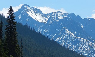
Porcupine Peak is a 7,762-foot-elevation (2,366-meter) mountain located in Skagit County of Washington state.

Round Mountain is a 5,369-foot mountain summit at the western edge of the North Cascades, in Skagit County of Washington state. It is located nine miles northwest of Darrington, Washington, and is situated on land administered by the Mount Baker-Snoqualmie National Forest. Round Mountain is remarkable for its 4,840 feet of prominence which ranks as the most in Skagit County, and eighth-most of all the mountains in Washington state. The nearest higher peak is Whitehorse Mountain, 7.85 miles (12.63 km) to the south-southeast. Precipitation runoff from Round Mountain drains into tributaries of the Stillaguamish River.

Mount Misch is a remote 7,435 ft mountain summit in the North Cascades, in Skagit County of Washington state. It is the highest point of the Buckindy Range, or Buckindy Ridge. It is located 19 miles east-northeast of Darrington, Washington, and 15 miles north-northwest of Glacier Peak which is one of the Cascade stratovolcanoes. It is situated in the Glacier Peak Wilderness on land administered by the Mount Baker-Snoqualmie National Forest. Mount Misch was named by mountaineer and author Fred Beckey for his friend Peter Misch (1909-1987), University of Washington geology professor and mountaineer, who was renowned for his study of the North Cascades. Precipitation runoff from Mount Misch and the unnamed Goat Creek glacier on its east slope drains into tributaries of the Suiattle River and ultimately the Skagit River.

Mount Chaval is a craggy 7,127-foot (2,172-metre) mountain summit located in Skagit County of Washington state. Situated within the Glacier Peak Wilderness, Mount Chaval is positioned west of the crest of the North Cascades Range, approximately 15 miles northeast of the town of Darrington. It has two subsidiary peaks, East Peak and Middle Peak, each 7040 ft. The nearest higher neighbor is Snowking Mountain, 2.51 miles (4.04 km) to the northeast. Precipitation runoff from Mount Chaval drains into tributaries of the Skagit River.

Dorado Needle is an 8,440+ ft mountain summit located in North Cascades National Park in Skagit County of Washington state. The peak lies 0.73 miles north of Eldorado Peak and 1.33 mi (2.14 km) southeast of Perdition Peak. It can be seen from the North Cascades Highway west of Marblemount at a road pullout along the Skagit River. The first ascent of the peak was made in July 1940 by Lloyd Anderson, Karl Boyer, and Tom Gorton via the Northwest Ridge. Precipitation runoff and glacier meltwater from the mountain drains into tributaries of the Skagit River.

Granite Mountain is a 6,692-foot (2,040-metre) mountain summit located in the Skagit Range, which is a subset of the North Cascades in Whatcom County of Washington state. It is situated 1.7 mi (2.7 km) south of Mount Chardonnay, and 1.2 mi (1.9 km) northwest of Hannegan Peak in the Mount Baker Wilderness, which is managed by the Mount Baker-Snoqualmie National Forest. Precipitation runoff from the mountain drains into tributaries of the Fraser River and the Nooksack River.

Mount Chardonnay is a prominent 7,020+ ft mountain summit located in the Skagit Range, which is a subset of the North Cascades in Whatcom County of Washington state. It is situated 1.7 mi (2.7 km) north of Granite Mountain and 2.75 mi (4.43 km) east of Goat Mountain in the Mount Baker Wilderness, which is managed by the Mount Baker-Snoqualmie National Forest. The nearest higher peak is Mount Sefrit, 2.77 mi (4.46 km) to the southwest. Precipitation runoff from the mountain drains into Silesia Creek, a tributary of the Fraser River.

Pinnacle Peak is a 7,386 ft (2,251 m) mountain summit in the North Cascades Range of Washington, United States. It is located within North Cascades National Park, between Pyramid Peak and Paul Bunyans Stump, which is the nearest higher peak. It rises steeply from Diablo Lake, one of the reservoirs on the Skagit River. It is part of a group of peaks that form the northern end of a chain running south through climbing destinations such as Colonial Peak and Snowfield Peak. Like many North Cascade peaks, Pinnacle Peak is more notable for its large, steep rise above local terrain than for its absolute elevation. Precipitation runoff from the mountain drains into Diablo Lake and Skagit River. The approach is via the Pyramid Lake Trail, starting near Diablo Dam on the North Cascades Highway. From the lake, there is route-finding up Pyramid Arm to Colonial Glacier.

Williams Peak is a prominent 2,123-metre (6,965-foot) mountain summit located in the Chilliwack River valley of the Cascade Mountains in southwestern British Columbia, Canada. It is situated 14 km (9 mi) north of the Canada–United States border, 6 km (4 mi) northwest of Chilliwack Lake, and 6.7 km (4 mi) southeast of Foley Peak, which is its nearest higher peak. Williams Peak is the highest point of the South Hope Mountains, which is a subset of the Skagit Range. Precipitation runoff from the peak drains into tributaries of the Chilliwack River. The mountain's name was officially adopted April 7, 1955, by the Geographical Names Board of Canada. Williams Peak was first climbed July 1908 by James J. McArthur and E.T. de Coeli via the southwest ridge.
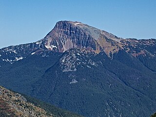
Mount Outram is a prominent 2,461-metre (8,074-foot) mountain summit located in the Canadian Cascades of southwestern British Columbia, Canada. It is the fourth-highest summit in the Hozameen Range, and highest point of the Manson Ridge subrange. It is situated 23 km (14 mi) southeast of Hope, and 14.5 km (9 mi) north-northeast of Silvertip Mountain, its nearest higher peak. Precipitation runoff from the peak drains into tributaries of the Coquihalla and Skagit Rivers. The mountain was known as Beaver Mountain as early as 1930 before being named for Sir James Outram, 1st Baronet, and being officially adopted October 6, 1936, by the Geographical Names Board of Canada. The first ascent of the mountain was made August 12, 1924, by Fred Perry, Herbert Selwood, Leslie Ford, and T.L. Thacker.

Mount Payne is a 2,468-metre (8,097-foot) mountain summit located in the Canadian Cascades of southwestern British Columbia, Canada. It is situated 27 km (17 mi) southeast of Hope, 14 km (9 mi) northeast of Chilliwack Lake, and 4 km (2 mi) west of Silvertip Mountain, which is its nearest higher peak. Following Silvertip, Mount Payne is the second-highest summit in the Hope Mountains, a subset of the Skagit Range. The peak was first climbed in 1950 by J. Bussell, H. Genschorek, I. Kay, A. Melville, and W. Sparling. The peak was named for Damasus Payne, a Benedictine monk and mountaineer who fell to his death on Edge Peak in 1978. Payne was responsible for naming mountains such as Mount Rohr and Mount Duke. He also carried all the materials for mass and communion up to the summit of Slesse Mountain to perform a ceremony to honor the victims of Trans-Canada Air Lines Flight 810. Mt. Payne's name was officially adopted May 7, 1984, by the Geographical Names Board of Canada. Precipitation runoff from the peak drains into headwaters of the Sumallo River, and into the Klesilkwa River, which is a tributary of the Skagit.

Skagit Peak is a 6,824-foot (2,080-metre) mountain summit located in the North Cascades, in Whatcom County of Washington state. It is situated on the western side of the Cascade crest, at the western edge of the Pasayten Wilderness, on land managed by the Okanogan–Wenatchee National Forest. Skagit Peak is part of the Hozameen Range, a subset of the North Cascades which also includes Hozomeen Mountain to the north, and Jack Mountain to the south. Precipitation runoff from this mountain drains into the Skagit River via Three Fools Creek and Ross Lake.
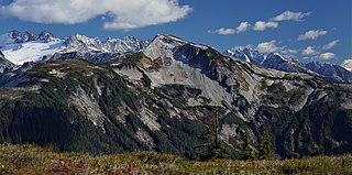
Easy Peak is a 6,613-foot (2,016-metre) mountain summit in the Skagit Range of the North Cascades, in Whatcom County of Washington state. Easy Peak is situated in North Cascades National Park, and is often climbed during the Easy Ridge approach to Mount Challenger and the remote northern Pickets. The nearest higher neighbor is Mineral Mountain, 2 mi (3.2 km) to the west, and Whatcom Peak is set 2.1 mi (3.4 km) to the east. Glacierets line the north slope of Easy Ridge between Easy Peak and Whatcom Peak. Precipitation runoff from this peak drains north into the Chilliwack River, or south into headwaters of the Baker River.

Red Face Mountain is a 7,141-foot-elevation (2,177-meter) summit in Whatcom County of Washington state.
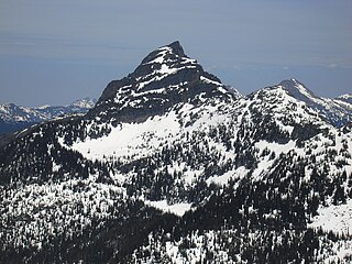
Mount Hatfield is a 2,227-metre (7,306-foot) mountain summit located in the Canadian Cascades of British Columbia, Canada.
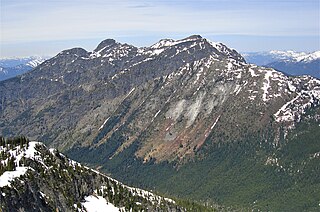
Macleod Peak is a 2,176-metre (7,139-foot) mountain summit located in the Canadian Cascades of British Columbia, Canada.

Mount Rideout is a 2,445-metre (8,022-foot) mountain summit located in the Canadian Cascades of British Columbia, Canada.
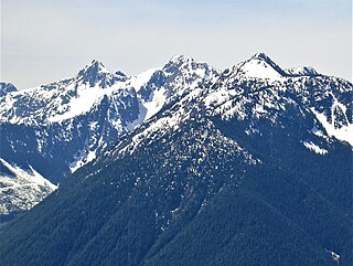
Mount Forddred is a 2,169-metre (7,116-foot) mountain summit located in the Canadian Cascades of British Columbia, Canada.


