
The Ancient Burying Ground is a historical cemetery at Phinney's Lane in Barnstable, Massachusetts. It is the oldest cemetery in the village of Centerville, and the only surviving civic element of its colonial origins. was listed on the National Register of Historic Places in 1987.

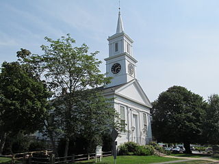
The Unitarian Universalist Meeting House of Provincetown is an historic church at 236 Commercial Street in Provincetown, Massachusetts. The Greek Revival building was built in 1847 based on a design by Benjamin Hallett, for a congregation that had been established in 1829. It is a massive post and beam timber-frame construction, and was originally built without the tower. The tower, which is telescopic in form, with Greek ornamentation, is the only surviving steeple in Provincetown, and is a landmark for seafarers.

The Wing's Neck Light is a historic lighthouse in the Pocasset village of Bourne, Massachusetts. It is located on Wing's Neck Road at the end of Wing's Neck, a peninsula between Pocasset Harbor and the Hog Island Channel, which provides access to the Cape Cod Canal. The first lighthouse was built in the site in 1849; it was a stone keeper's house with a wood-frame tower above, and was destroyed by fire in 1878.
The Centerville Historic District is a historic district encompassing the heart of the village of Centerville in Barnstable, Massachusetts. The district extends along Main Street from a point north of its junction with Old Stage Road and Park Avenue, south to the junction with Church Hill Road. Most of the buildings in the district were built in the middle decades of the 19th century, although its oldest building, the Austin Bearse House, was built c. 1690. The area's growth was spurred by the relocation in 1826 of the Congregational Church building to its present location. The district was listed on the National Register of Historic Places in 1987.
The Goodspeed House is a historic house in Barnstable, Massachusetts. It is believed to have been built by Roger Goodspeed, Marstons Mills' first settler. The house was listed on the National Register of Historic Places in 1987.

The Gideon Hawley House is a historic house along Massachusetts Route 28 near the Cotuit village of Barnstable, Massachusetts.
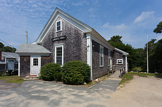
Liberty Hall is a historic community building in the Marstons Mills village of Barnstable, Massachusetts. The 1+1⁄2-story structure was built in 1859 by a local community group as a function hall. It has modest Greek Revival styling, with an entablature and corner pilasters, large 12-over-12 sash windows, and an entry vestibule projecting at an angle from one corner. It continues to be used as a community function space, although it was adapted for a time as the local Methodist church's parish hall.

The Hinckley Homestead is a historic house located in the Marstons Mills area of Barnstable, Massachusetts.

The Hyannis Road Historic District is a residential historic district at the northern end of Hyannis Road in Barnstable, Massachusetts. It includes ten properties built between c. 1790 and 1855, representing southward growth from the traditional village center of Barnstable toward the growing village of Hyannis. The properties lie along Bow Lane and Hyannis Road, between the Old King's Highway and the right-of-way of the Cape Cod Railroad. The district was listed on the National Register of Historic Places in 1987.

The Marstons Mills Community Church, formerly the Methodist Church, is a historic church building in the Marstons Mills village of Barnstable, Massachusetts. The white clapboard church was built in the town of Yarmouth, and moved to Marstons Mills in 1830. Its small belfry tower was added sometime between 1888 and 1908, around the same time it acquired some of its Queen Anne stylistic elements. In 1987, the church was listed on the National Register of Historic Places for its architecture and for its role in community history.

The William Marston House is a historic house located in the Marstons Mills area of Barnstable, Massachusetts.

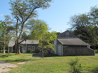
The Merrill Estate is a historic estate in the Marstons Mills section of Barnstable, Massachusetts. The estate house started as a 1+1⁄2-story Cape style house, with five bays and a large central chimney, built c. 1750–1775. This Georgian structure was extended in the middle of the 19th century with a 1+1⁄2-story Greek Revival ell that was added to the front of the house. The property includes an old English barn.

The Mill Way Historic District encompasses a residential area significant in the development of the maritime industry in Barnstable Village, Massachusetts. It includes thirteen houses, ten on Mill Way and three on adjacent Freezer Road, just north of the Old King's Highway. The district was listed on the National Register of Historic Places in 1987.

The Old King's Highway Historic District encompasses what was historically the principal east–west thoroughfare through Barnstable, Massachusetts. It encompasses Barnstable's entire length of what is now designated Massachusetts Route 6A, called Main Street, between the town lines of Sandwich and Yarmouth. It includes more than 1,000 acres (400 ha) and all buildings whose properties are front on the road, nearly 500 in all. The area consists of the main population centers of Barnstable from its founding in the late 1630s until the mid-19th century when the southern parts of the community became more significant in economic prominence. The district was listed on the National Register of Historic Places in 1987.
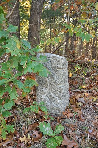
The town of Barnstable, Massachusetts has four surviving stone markers that were used in colonial days to mark the town's boundaries with its neighbors. All four are listed on the National Register of Historic Places, three of them individually, and one as part of the Old King's Highway Historic District. Barnstable was established in 1639.

The Santuit Historic District encompasses a cluster of historic houses around the junction of Falmouth Road and Main Street in the Santuit village of Barnstable, Massachusetts. It includes eight houses, six of which are historically significant for their association with the Crocker family, who were the first settlers of the area in the 18th century. The district was listed on the National Register of Historic Places in 1987.
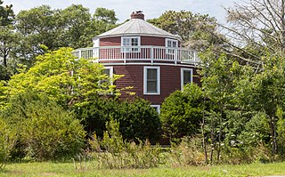
The Round House is a historic house located at 971 West Main Street in the Centerville village of Barnstable, Massachusetts.

The Nelson Rhodehouse House is a historic house located in the Cotuit village of Barnstable, Massachusetts.

The John Richardson House is a historic house in the Centerville area of Barnstable, Massachusetts. The 1+1⁄2-story wood-frame Cape style house was built c. 1795 by John Richardson, member of a locally prominent family and the first teacher at the Phinney's Lane School. It is four bays wide, with the main entrance and chimney in the second bay from the left. The house is one of Centerville's older houses, located near the site of its first meetinghouse and cemetery.

The First Congregational Parish Historic District encompasses the oldest church building in Truro, Massachusetts and adjacent historic resources. The congregation was established in 1711, and is now occupying its third church, a Federal/Greek Revival building erected in 1827. The tower houses a bell cast by Paul Revere. Adjacent to the church and part of its setting is the Congregational Cemetery, whose earliest recorded burial is in 1810, and has been associated with the church since its construction. The cemetery contains a memorial erected in 1841, commemorating the loss of 57 Truro residents and seven ships in a gale on October 3. 1841.


