Mattawa, Washington

Last updated

Mattawa
Mattawa City Hall IMG 1447.JPG
Mattawa City Hall (2008)
Grant County Washington Incorporated and Unincorporated areas Mattawa Highlighted.svg
Location of Mattawa, Washington
Coordinates: 46°44′15″N119°53′21″W / 46.73750°N 119.88917°W / 46.73750; -119.88917
CountryUnited States
State Washington
County Grant
Government
  Type Mayor–council [1]
   Mayor Maria M. Celaya [1]
Area
[2]
  Total
0.92 sq mi (2.39 km2)
  Land0.92 sq mi (2.39 km2)
  Water0.00 sq mi (0.00 km2)
Elevation
[3]
755 ft (230 m)
Population
 (2020) [4]
  Total
3,335
  Estimate 
(2021) [5]
3,627
  Density5,160.52/sq mi (1,992.03/km2)
Time zone UTC-8 (PST)
  Summer (DST) UTC-7 (PDT)
ZIP code
99349
Area code 509
FIPS code 53-44165
GNIS feature ID2412963 [3]
Website cityofmattawa.com

Mattawa is an incorporated city in Grant County, Washington, United States. The population was 3,335 at the 2020 census. [4]

Contents

History

Exterior view of straw bale library in Mattawa, Washington taken in 2008 (constructed 2002 by IronStraw Group). Matawa Straw Bale Library IMG 1443.JPG
Exterior view of straw bale library in Mattawa, Washington taken in 2008 (constructed 2002 by IronStraw Group).

The town of Mattawa was originally platted in 1909 by E. and Eva Campbell, but was not incorporated at that time. [6] With the construction of nearby Priest Rapids Dam and Wanapum Dam, the town boomed with construction workers. [7] Mattawa was officially incorporated on June 3, 1958. The Port of Mattawa was also established in 1958. [8] Mattawa is also home to the first straw bale library in the United States. [9] On December 3, 2009, the City of Mattawa became a non-charter code city.

Geography

According to the United States Census Bureau, the town has a total area of 0.74 square miles (1.92 km2), all of it land. [10]

Climate

According to the Köppen Climate Classification system, Mattawa has a semi-arid climate, abbreviated "BSk" on climate maps.

Demographics

Historical population
CensusPop.Note
1960 394
1970 180−54.3%
1980 29966.1%
1990 941214.7%
2000 2,609177.3%
2010 4,43770.1%
2020 3,335−24.8%
2021 (est.)3,627 [5] 8.8%
U.S. Decennial Census [11]
2020 Census [4]

The Mattawa Police Department (MAPD) currently consists of a police chief and four full-time, fully commissioned general-authority Washington police officers.

Mattawa is served by the Wahluke School District.

2010 census

As of the 2010 census, [12] there were 4,437 people, 791 households, and 725 families residing in the town. The population density was 5,995.9 inhabitants per square mile (2,315.0/km2). There were 843 housing units at an average density of 1,139.2 per square mile (439.8/km2). The racial makeup of the town was 45.0% White, 0.9% African American, 1.1% Native American, 0.1% Asian, 49.7% from other races, and 3.4% from two or more races. Hispanic or Latino of any race were 95.7% of the population.

There were 791 households, of which 82.8% had children under the age of 18 living with them, 70.7% were married couples living together, 10.6% had a female householder with no husband present, 10.4% had a male householder with no wife present, and 8.3% were non-families. 2.3% of all households were made up of individuals, and 0.6% had someone living alone who was 65 years of age or older. The average household size was 5.61 and the average family size was 5.28.

The median age in the town was 22 years. 42% of residents were under the age of 18; 14.3% were between the ages of 18 and 24; 33.1% were from 25 to 44; 8.7% were from 45 to 64; and 1.8% were 65 years of age or older. The gender makeup of the town was 55.7% male and 44.3% female.

2000 census

As of the 2000 census, there were 2,609 people, 495 households, and 438 families residing in the town. The population density was 5,281.7 people per square mile (2,055.8/km2). There were 576 housing units at an average density of 1,166.1 per square mile (453.9/km2). The racial makeup of the town was 29.59% White, 0.19% African American, 0.54% Native American, 0.92% Asian, 65.85% from other races, and 2.91% from two or more races. Hispanic or Latino of any race were 89.80% of the population.

There were 495 households, out of which 66.7% had children under the age of 18 living with them, 64.2% were married couples living together, 10.7% had a female householder with no husband present, and 11.5% were non-families. 5.5% of all households were made up of individuals, and 2.0% had someone living alone who was 65 years of age or older. The average household size was 5.27 and the average family size was 4.79.

In the city, the population was spread out, with 38.1% under the age of 18, 20.4% from 18 to 24, 32.4% from 25 to 44, 7.6% from 45 to 64, and 1.5% who were 65 years of age or older. The median age was 22 years. For every 100 females, there were 151.8 males. For every 100 females age 18 and over, there were 179.2 males.

The median income for a household in the town was $31,964, and the median income for a family was $25,921. Males had a median income of $13,669 versus $13,333 for females. The per capita income for the city was $7,510. About 30.6% of families and 34.4% of the population were below the poverty line, including 38.0% of those under age 18 and 42.6% of those age 65 or over.

Related Research Articles

<span class="mw-page-title-main">Ainsworth, Iowa</span> City in Iowa, United States

Ainsworth is a city in Washington County, Iowa, United States. It is a part of the Iowa City, Iowa Metropolitan Statistical Area. The population was 511 at the 2020 census. It is part of the Highland Community School District.

<span class="mw-page-title-main">Washington, Iowa</span> City in Iowa, United States

Washington is a city in and the county seat of Washington County, Iowa, United States. It is part of the Iowa City, Iowa Metropolitan Statistical Area. The population was 7,352 at the time of the 2020 census.

<span class="mw-page-title-main">Dellwood, Minnesota</span> City in Minnesota, United States

Dellwood is a city in Washington County, Minnesota, United States and a suburb of St. Paul. The population was 1,063 at the 2010 census.

<span class="mw-page-title-main">Washington, Missouri</span> City in the United States

Washington is a city on the south banks of the Missouri River, 50 miles west of St. Louis, Missouri. With an estimated population of 15,075, it is the largest city in Franklin County, Missouri. It is notable for being the "corncob pipe capital of the world," with Missouri Meerschaum located on the city's riverfront.

<span class="mw-page-title-main">Bloomsdale, Missouri</span> City in Missouri, United States

Bloomsdale is a city in Ste. Genevieve County, Missouri, United States. The population was 639 at the 2020 census.

<span class="mw-page-title-main">George, Washington</span> City in Washington, United States

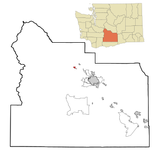
George is a city in Grant County, Washington, United States. The population was 809 at the 2020 census. The "humorous homage" to President George Washington has landed George, Washington on lists of unusual place names.

<span class="mw-page-title-main">Normandy Park, Washington</span> City in Washington, United States

Normandy Park is a city in King County, Washington, United States. The population was 6,771 at the 2020 census.

<span class="mw-page-title-main">Elmer City, Washington</span> Town in Washington, United States

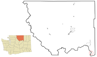
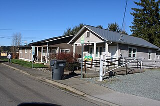
Elmer City is a town in Okanogan County, Washington, United States. The population was 239 at the 2020 census.

<span class="mw-page-title-main">South Bend, Washington</span> City in Washington, United States

South Bend is a city in and the county seat of Pacific County, Washington, United States. The population was 1,746 as of the 2020 census. The town is widely-known for its oyster production and scenery.

<span class="mw-page-title-main">South Prairie, Washington</span> Town in Pierce County, Washington, United States

South Prairie is a town in Pierce County, Washington, United States. The population was 373 at the 2020 census.

<span class="mw-page-title-main">Rockford, Washington</span> Town in Washington, United States

Rockford is a town in Spokane County, Washington, United States. The population was 522 at the 2020 census.

<span class="mw-page-title-main">Kettle Falls, Washington</span> City in Washington, United States

Kettle Falls is a city in Stevens County, Washington, United States, named for the nearby Kettle Falls on the Kettle River. The city itself is located on the Colville River immediately upstream from its confluence with the Columbia River. The population of the city was 1,636 at the 2020 census.

<span class="mw-page-title-main">Farmington, Washington</span> Town in Washington, United States

Farmington is a town in Whitman County, Washington, United States. The population was 131 at the 2020 census.

<span class="mw-page-title-main">Garfield, Washington</span> Town in Washington, United States

Garfield is a city in Whitman County, Washington, United States. The population was 562 at the 2020 census.

<span class="mw-page-title-main">Malden, Washington</span> Town in Washington, United States

Malden is a town in Whitman County, eastern Washington, United States. The population was 216 at the 2020 census. 80 percent of the buildings were destroyed by a wildfire on September 7, 2020.

<span class="mw-page-title-main">Oakesdale, Washington</span> Town in Washington, United States

Oakesdale is a town in Whitman County, Washington, United States. The population was 395 at the 2020 census.

<span class="mw-page-title-main">Harrah, Washington</span> Town in Washington, United States

Harrah is a town in Yakima County, Washington, United States. The population was 585 at the 2020 census. It is on the Yakama Indian Reservation.

<span class="mw-page-title-main">Naches, Washington</span> Town in Washington, United States

Naches is a town in Yakima County, Washington, United States. The population was 1,084 at the 2020 census. The town is located along the Naches River west of Yakima near the eastern foothills of the Cascade Range.

<span class="mw-page-title-main">Tieton, Washington</span> City in Washington, United States

Tieton is a city in Yakima County, Washington, United States. The population was 1,389 at the 2020 census.

<span class="mw-page-title-main">Glen Dale, West Virginia</span> Town in West Virginia

Glen Dale is a city in Marshall County, West Virginia, United States, along the Ohio River. It is part of the Wheeling, West Virginia Metropolitan Statistical Area. The population was 1,514 at the 2020 census. Glen Dale was incorporated in 1924. It is in the northwest part of the county, which is above the Mason–Dixon line and forms the base of the Northern Panhandle of West Virginia.

References

  1. 1 2 "Mayor's Office / City Council". City of Mattawa. Retrieved April 9, 2022.
  2. "2019 U.S. Gazetteer Files". United States Census Bureau. Retrieved August 7, 2020.
  3. 1 2 U.S. Geological Survey Geographic Names Information System: Mattawa, Washington
  4. 1 2 3 "Explore Census Data". United States Census Bureau . Retrieved March 18, 2022.
  5. 1 2 "City and Town Population Totals: 2020-2021". United States Census Bureau. June 22, 2022. Retrieved June 22, 2022.
  6. "Mattawa, Washington". Archived from the original on June 25, 2009. Retrieved February 18, 2009.
  7. "Mattawa Area News". Washington Home Town News.
  8. "Grant County commissioners pass resolution on October 6, 1958, setting vote on creating Port of Mattawa". February 23, 2011. Retrieved August 7, 2023.
  9. Pioneering Achievements (PDF), IronStraw group, retrieved June 17, 2009
  10. "US Gazetteer files 2010". United States Census Bureau. Archived from the original on January 25, 2012. Retrieved December 19, 2012.
  11. United States Census Bureau. "Census of Population and Housing" . Retrieved October 2, 2013.
  12. "U.S. Census website". United States Census Bureau . Retrieved December 19, 2012.