
Pemba is a port city in Mozambique. It is the capital of the province of Cabo Delgado and lies on a peninsula in Pemba Bay.
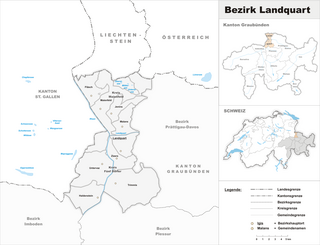
Landquart District is a former administrative district in the canton of Graubünden, Switzerland. It had an area of 193.91 km2 (74.87 sq mi) and has a population of 25,555 in 2015. It was replaced with the Landquart Region on 1 January 2017 as part of a reorganization of the Canton.

This is a list of the extreme points of Azerbaijan, the points that are farther north, south, east or west than any other location.

Janík is a village and municipality in Košice-okolie District in the Kosice Region of eastern Slovakia.

Zlatník is a village and municipality in Vranov nad Topľou District in the Prešov Region of eastern Slovakia.
The Roman Catholic Diocese of Pemba is a diocese located in the city of Pemba in the Ecclesiastical province of Nampula in Mozambique.
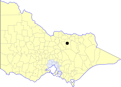
The City of Benalla was a local government area about 188 kilometres (117 mi) northeast of Melbourne, the state capital of Victoria, Australia. The city, which was completely surrounded by the Shire of Benalla, covered an area of 17.76 square kilometres (6.9 sq mi), and existed from 1948 until 1994.
Maubin District is a district in Ayeyarwady Division, Myanmar. It consists of 39 wards, 235 village groups and 1642 villages organized into four townships - Maubin, Pantanaw, Nyaungdon and Danuphyu. The district lies on a flat plain, cut by many streams, which is 1,362 feet above sea level. It has an area of 1651.49 square miles. The majority of the population are Burmese and Kayin nationals.

Kalinowo-Solki is a village in the administrative district of Gmina Kulesze Kościelne, within Wysokie Mazowieckie County, Podlaskie Voivodeship, in north-eastern Poland. It lies approximately 6 kilometres (4 mi) north-east of Wysokie Mazowieckie and 45 km (28 mi) west of the regional capital Białystok.
Kalinowo-Czosnowo is a village in the administrative district of Gmina Wysokie Mazowieckie, within Wysokie Mazowieckie County, Podlaskie Voivodeship, in north-eastern Poland. It lies approximately 6 kilometres (4 mi) north-east of Wysokie Mazowieckie and 45 km (28 mi) west of the regional capital Białystok.
Zaborów Pierwszy is a village in the administrative district of Gmina Tomaszów Mazowiecki, within Tomaszów Mazowiecki County, Łódź Voivodeship, in central Poland. It lies approximately 6 kilometres (4 mi) north-west of Tomaszów Mazowiecki and 44 km (27 mi) south-east of the regional capital Łódź.
Jastew is a village in the administrative district of Gmina Dębno, within Brzesko County, Lesser Poland Voivodeship, in southern Poland. It lies approximately 4 kilometres (2 mi) north-west of Dębno, 4 km (2 mi) east of Brzesko, and 54 km (34 mi) east of the regional capital Kraków.
Goldhap is a village development committee in Jhapa District in the Mechi Zone of south-eastern Nepal. At the time of the 1991 Nepal census it had a population of 7,393 in 1,252 households.
Radolinek is a village in the administrative district of Gmina Czarnków, within Czarnków-Trzcianka County, Greater Poland Voivodeship, in west-central Poland. It lies approximately 8 kilometres (5 mi) north of Czarnków and 68 km (42 mi) north of the regional capital Poznań.
Orzechowo is a village in the administrative district of Gmina Dobre Miasto, within Olsztyn County, Warmian-Masurian Voivodeship, in northern Poland. It lies approximately 11 kilometres (7 mi) east of Dobre Miasto and 21 km (13 mi) north of the regional capital Olsztyn.
Pilkichha is a village in Khutahan, Jaunpur district, Varanasi division, Uttar Pradesh, India.
Peantse is a village in Lääneranna Parish, Pärnu County in southwestern Estonia.
Kumarevo is a village in the municipality of Vranje, Serbia. According to the 2002 census, the village has a population of 283 people.
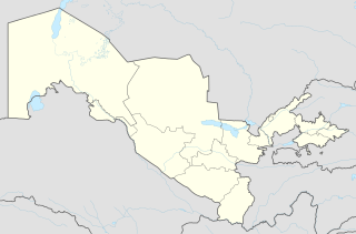
Akkula, alternate names being Ak-Kul' and Ak-Kulya, is a locality in Nurata District, Navoiy Region of Uzbekistan. The settlement in within the relative vicinity of Aydar Lake.
This page is based on this
Wikipedia article Text is available under the
CC BY-SA 4.0 license; additional terms may apply.
Images, videos and audio are available under their respective licenses.
